Censuses of nutrient salt monitoring stations in the western Mediterranean sub-region (1962 to 2010)
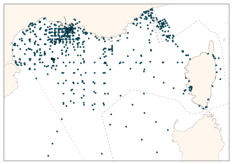
The consolidated database shows the spatial distribution of sampling effort by French and Monaco oceanographic campaigns.
The measures are divided between the mouth of the Rhone, the Gulf of Lions, and Ligurian and Provence seas.
The database contains 55 campaigns or time series, over 5 decades from 1962 to 2010. 28 are oceanographic campaigns of spatial strategy (some were revisited), 14 of temporal strategy, 2 of spatio-temporal strategy, and 1 one-time campaign.
In total, it has 24,886 entries including: 19,027 nitrate data - 13,826 nitrite data - 11,452 ammonium data – 20,936 phosphates data – 14,605 silicates data.
The majority (92%) of associated temperature and salinity data is available.
Simple
- Title
-
Censuses of nutrient salt monitoring stations in the western Mediterranean sub-region (1962 to 2010)
- Date (Creation)
- 2011-09-01
- Citation identifier
- bdd_cons_2_metadata_v2.shp
- Abstract
-
The consolidated database shows the spatial distribution of sampling effort by French and Monaco oceanographic campaigns.
The measures are divided between the mouth of the Rhone, the Gulf of Lions, and Ligurian and Provence seas.
The database contains 55 campaigns or time series, over 5 decades from 1962 to 2010. 28 are oceanographic campaigns of spatial strategy (some were revisited), 14 of temporal strategy, 2 of spatio-temporal strategy, and 1 one-time campaign.
In total, it has 24,886 entries including: 19,027 nitrate data - 13,826 nitrite data - 11,452 ammonium data – 20,936 phosphates data – 14,605 silicates data.
The majority (92%) of associated temperature and salinity data is available.
- Credit
-
LMGEM - Centre d’Océanologie de Marseille
- Point of contact
-
Organisation name Individual name Electronic mail address Role LMGEM - Centre d’Océanologie de Marseille
Patrick Raimbault
Local service desk
-
Thèmes Sextant
-
-
/Human Activities/Scientific Activities
-
- Theme
-
-
spatio-temporal distribution; nutrients; monitoring stations; nutrient salts
-
-
GEMET - INSPIRE themes, version 1.0
-
-
Environmental monitoring facilities
-
-
Sous-regions marines
-
-
Western Mediterranean
-
- Access constraints
- Intellectual property rights
- Use constraints
- Intellectual property rights
- Classification
- Unclassified
- Spatial representation type
- Vector
- Language
- Français
- Character set
- UTF8
- Topic category
-
- Geoscientific information
- Oceans
))
- Begin date
- 1962-01-01T16:02:00
- End date
- 2011-12-31T16:02:00
- Reference system identifier
- EPSG / WGS84 géographiques / 7.4
- Distribution format
-
Name Version shape ESRI
ArcGIS 9.3.1
- OnLine resource
-
Protocol Linkage Name WWW:LINK
http://wwz.ifremer.fr/dcsmm site internet Ifremer dédié à la Directive Cadre Stratégie pour le Milieu Marin
WWW:LINK
http://www.ifremer.fr/sextant/fr/web/dcsmm/123_repartition_spatio-temporellle_nutriments carthothèque DCSMM
- Hierarchy level
- Dataset
- Statement
-
Databases:
The data presented in this paper were collected through the data authors, observation services (RNO, SOMLIT, DYFAMED, MOOSE) and online databases of French oceanographic campaigns (SISMER) or digital media (MEDAR / MEDATLAS). In regards of the formats inhomogeneity of different data sources (dates, locations, units, ...), it was necessary to perform systematic control of all imported variables. To put the data in their nutrient hydrological context, the temperature and salinity data were also collected.
Data Validation:
A statistical and graphical analysis was conducted to detect and correct any data reporting errors and identify aberrant or suspicious values.
Given the high dispersion of data related to the continental influence, the search for possible outliers was preformed by analyzing distributions in regards to depth and salinity. These analysis were performed for each nutrient salt. They have enabled the detection of very high concentrations, outliers that were not kept unless they could be associated with a desalination related to freshwater inflow of continental origin. On the other hand, the high values associated with marine waters and deep waters (salinity> 37) have been removed. This procedure and the overlapping of sources allowed the compilation error correction, elimination of dubious quality and values to obtain a consolidated database.
Metadata
- File identifier
- 777b2ee1-bb76-4b49-af7e-3a1581a3dfc5
- Metadata language
- Français
- Other language
-
Language Character encoding English
- Character set
- UTF8
- Hierarchy level
- Dataset
- Hierarchy level name
-
Jeu de données
- Date stamp
- 2020-06-04T00:23:21
- Metadata standard name
-
ISO 19115:2003/19139 - SEXTANT
- Metadata standard version
-
1.0
- Metadata author
-
Organisation name Individual name Electronic mail address Role Ifremer Brest - Geosciences Marines
Etienne Laffay
Local service desk
accessData
Overviews
)))