Marine Ecosystem Monitoring System – Modelling Marine Ecosystems and Satellite Monitoring (MEMMS) -
Monitoring and understanding of marine ecosystems, marine population dynamics, commercial species and protected species.
Themes covered:
- Functional ecology
- marine population dynamics
- Impact of climate variability
- Ecosystem management
- Spatialised operational management
System functions
- Definition of key areas and configuration of the population dynamics model
- Acquisition of satellite data and in situ ocean data
- Data processing and production of geographical layers
- Data management and storage
- Data distribution
Coverage
- Oceans worldwide
- Ocean basins
- Ocean regions
- Mediterranean sea
Specifics (see functioning, qualification system, custom services for users)
- Customised services for users
Simple
- Title
-
Marine Ecosystem Monitoring System – Modelling Marine Ecosystems and Satellite Monitoring (MEMMS) -
- Date (Creation)
- 2006-01-01T00:00:00
- Citation identifier
- FR-DCSMM-PDS-MEMMS
- Presentation form
- Digital profile
- Abstract
-
Monitoring and understanding of marine ecosystems, marine population dynamics, commercial species and protected species.
Themes covered:
- Functional ecology
- marine population dynamics
- Impact of climate variability
- Ecosystem management
- Spatialised operational management
System functions
- Definition of key areas and configuration of the population dynamics model
- Acquisition of satellite data and in situ ocean data
- Data processing and production of geographical layers
- Data management and storage
- Data distribution
Coverage
- Oceans worldwide
- Ocean basins
- Ocean regions
- Mediterranean sea
Specifics (see functioning, qualification system, custom services for users)
- Customised services for users
- Credit
-
Data producer : CLS
- Status
- On going
- Point of contact
-
Organisation name Individual name Electronic mail address Role CLS
Blanc Frederique
Local service desk
- Maintenance and update frequency
- Annually
- Maintenance note
-
Network duration : Unknown
- Theme
-
-
Spatial characteristics of the marine environment
-
Variability
-
Biodiversity component
-
Commercial species
-
Protected species
-
Polluted species
-
Pelagic species
-
Turtles
-
Tuna
-
Swordfish
-
Marlin
-
Migration routes
-
Corridors
-
Hot spots
-
Migration period
-
Vital areas
-
-
GEMET - INSPIRE themes, version 1.0
-
-
Environmental monitoring facilities
-
-
Sous-regions marines
-
-
National
-
-
DCSMM : Type d'espace concerné
-
-
Pas d'espace particulier concerné
-
-
DCSMM : Descripteurs
-
-
D1: Deep-sea benthic habitats
-
D2: Non-indigenous species
-
D3: Commercially Exploited Species
-
D4: Marine Food Webs
-
D8: Chemical contaminants
-
-
DCSMM : Méthodes de recueil des données
-
-
Télémétrie
-
Observation indirecte
-
-
Thèmes Sextant
-
-
/Biological Environment/Habitats
-
- Access constraints
- Other restrictions
- Other legal constraints
-
Restricted access
- Use limitation
-
Data are produced within the context of specific contracts. Costs to users include the analysis produced by CLS and access to the data in various formats (data, reports, participation in scientific conferences or expert committees, training to use the delivered system).
- Spatial representation type
- Vector
- Denominator
- 50000
- Language
- Français
- Character set
- UTF8
- Topic category
-
- Oceans
))
- Supplemental Information
-
Project leader : CLS 2006
Prime contractor : CLS 2013
Backers :
CLS for the overall infrastructure
Clients for regional infrastructure (costs relating to studies or the purchase of premises)
- Reference system identifier
- EPSG / WGS 84 (EPSG:4326) / 7.9
- Topology level
- Geometry only
- Geometric object type
- Complex
- Geometric object count
- 0
- Hierarchy level
- Dataset
Conformance result
- Title
-
Inspire specifications
- Date (Creation)
- 2012-01-16
- Explanation
-
Non assessed
- Pass
- Statement
-
Since 2006 : Stock status study phase
To be conducted in new areas
2013-2015 : Transition to the operational phase with daily estimations
Demonstration in Indonesia
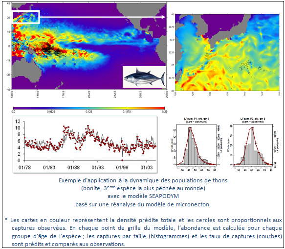
In 2066, CLS created MEMMS (Marine Ecosystem and Satellite Monitoring System) to promote the monitoring and sustainable development of marine resources. The aim of this new activity is to develop tools, products and applications at the interface between operational oceanography and users, be they academics, institutions or private users. The long-term aim is to develop an innovative model of the oceanic ecosystem (SEAPODYM) which is already the object of many applications within the context of academic research or management (tuna commissions, fishing agencies, etc.).
One key component of this model is the representation of micronekton, that is to say the tiny marine organism which are the prey for large oceanic predators and which are themselves the predators of all species of the pelagic ecosystem. The model predicts the production and biomass of 6 functional groups of micronekton between the surface and depths of 1000m. an additional group represents the zooplankon which the larvae feed on.
Thus, by combining the system’s various key variables with physical variables (temperature, current, oxygen content), for a given species it is possible to create models and predict:
- the egg-laying habitat
- a larval density index
- a feeding habitat
- areas of concentrations and migration routes
- hotspots providing consistently favourable conditions.
The other component of the model simulates the spatial dynamics of predators. The model is based on defining the indices of egg-laying habitats and feeding grounds (see below). These indices are used to influence movement and migration between egg-laying and feeding areas. During its evolution, each species has developed biological characteristics which must be taken into account in order to define its habitat. For example, a fish will be sensitive to oxygen content levels, whereas this is not the case for a cetacean or turtle which breathes at the surface. However, the diving capacity of these species may be limited depending on how long they can hold their breath. Observations (electronic tagging, fishing effort and catch) can be used to optimise the parameters relating to habitat and movement for a given species. In the complete version of the model, that which simulates the dynamics of a whole population and fishing impact, this model provides:
- dynamic spatial distribution of larval density
- dynamic spatial distribution of density of juveniles (biomass)
- dynamic spatial distribution of density of immature adults (biomass)
- dynamic spatial distribution of density of mature adults (biomass)
- Stock production (recruitment)
- Predicted catched according to fishing effort
- The impact of management measures (temporal or spatial closures, changes in fishing effort or technique).
This model has successfully be applied to numerous species:
- Pacific bonito
- Bigeye tuna
- South Pacific Albacore
- Pacific Yellowfin tuna
- Pacific swordfish
Applications are being developed for :
- North Atlantic tuna
- Pacific jack mackerel
- Peruvian anchoveta
- Marine turtles
- Atlantic blue marlin
- Atlantic Bluefin tuna
- Description
-
Data type :
- Mesozooplankton
- Epipelagic Micronekton
- Mesopelagic Micronekton
- Migratory Mesopelagic Micronekton
- Bathypelagic Micronekton
- Migratory Bathypelagic Micronekton
- Highly Migratory Bathypelagic Micronekton
Spatial characteristics of the marine habitat and its variability, biodiversity component
- commercial species, protected species, polluted species, pelagic species, turtles
Measured or observed parameters :
Zooplankton and micronekton
- resolution varying from 1°x month to 1/12°x day
Marine Population dynamics
Migration routes (within space, altitute or depth, depending on the latitude)
- Migration period (seasons and variability)
- Vital zones (egg-laying, nursery, feeding grounds)
- Population structure (size, weight, age, sex)
Parameters resolution : variable
from 2°x month to 1/12°x day
Update frequency : Annual to weekly
observation frequency : Variable
- Description
-
Protocols are documented (scientific publications and reports), and are available upon request from CLS. They are sent to users.
Results produced by MEMMS are archived by CLS, Toulouse.
- Description
-
The work currently takes place within a scientific context and its industrialisation is in its early stages. Within the context of French Development Agency funding, it is in the process of becoming operational for Indonesia.
The model is calculated within a rigorous framework of parameter optimisation and simulation validation.
- Description
-
Sampling method : Spatial
- Description
-
device associated : Centre de traitement régional MEMMS
Metadata
- File identifier
- 7800aa55-2fb8-406c-b08a-3ea88f694a1f
- Metadata language
- Français
- Other language
-
Language Character encoding English
- Character set
- UTF8
- Hierarchy level
- Series
- Date stamp
- 2020-06-04T00:28:14
- Metadata standard name
-
ISO 19115:2003/19139 - SEXTANT
- Metadata standard version
-
1.0
- Metadata author
-
Organisation name Individual name Electronic mail address Role Sextant
Local service desk
accessData
Overviews
)))