Dynamic of Atmospheric Flow in the Mediterranean - DYFAMED -
DYFAMED is a model site which represents the physical and biogeochemical conditions found off the Mediterranean coast (fast water residence times, atmospheric dust, changes in deep water, etc.). It is recognised as being one of the reference site for oceanographic observation (OceanSITES).
Simple
- Title
-
Dynamic of Atmospheric Flow in the Mediterranean - DYFAMED -
- Date (Creation)
- 1995-01-01T00:00:00
- Citation identifier
- FR-DCSMM-PDS-DYFAMED
- Presentation form
- Digital profile
- Abstract
-
DYFAMED is a model site which represents the physical and biogeochemical conditions found off the Mediterranean coast (fast water residence times, atmospheric dust, changes in deep water, etc.). It is recognised as being one of the reference site for oceanographic observation (OceanSITES).
- Purpose
-
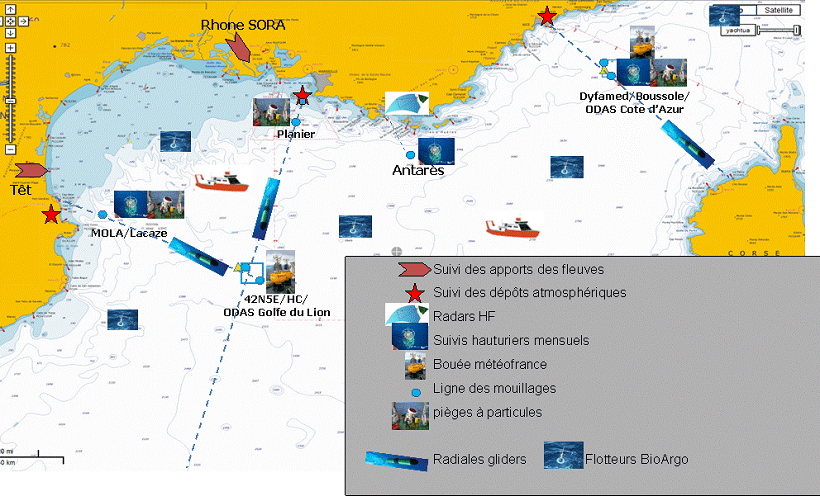
The main aim of the observations conducted at this site is to observe the evolution of the marine ecosystem in the Ligurian Sea and its reaction to climatic and man-made effects and their changes over time. The DYFAMED site is off the coast of the Ligurian Sea (30 miles from NICE, 2350m above the sea floor), where the Levantine waters from the eastern basin flow towards the Golf of Lion.
This site is protected from the influences of the coast by the North Current, thus forming a hydrological front. This site experiences high biogeochemical variability, from mesotrophic (spring bloom) to oligotrophic conditions (summer season). These conditions are significantly limited by deposits of atmospheric dust and highly variable hydrological conditions (mixed during winter compared with clear stratification during the summer). All of these factors lead to materials (and carbon) being drifted toward deep water.
- Status
- On going
- Point of contact
-
Organisation name Individual name Electronic mail address Role UMS829
Coppola Laurent
Local service desk
- Maintenance and update frequency
- Monthly
- Maintenance note
-
Network Duration: temporary Network
- Theme
-
-
Biogeochemical variability
-
Changes in the marine ecosystem
-
-
GEMET - INSPIRE themes, version 1.0
-
-
Environmental monitoring facilities
-
-
Sous-regions marines
-
-
/Metropolitan France/Western Mediterranean
-
-
DCSMM : Type d'espace concerné
-
-
Pas d'espace particulier concerné
-
-
DCSMM : Descripteurs
-
-
D7: Hydrographical Conditions
-
D1: Pelagic Habitats
-
D4: Marine Food Webs
-
D5: Eutrophication
-
-
DCSMM : Méthodes de recueil des données
-
-
Observation directe
-
Observation par point
-
Observation indirecte
-
Observation par transect
-
Piégeage, capture
-
-
Thèmes Sextant
-
-
/Physical Environment/Coastal Hydrodynamics
-
- Access constraints
- Other restrictions
- Other legal constraints
-
Free access
- Spatial representation type
- Vector
- Denominator
- 50000
- Language
- Français
- Character set
- UTF8
- Topic category
-
- Oceans
))
- Supplemental Information
-
Prime contractor :
Jean Claude Marty 1988-2006
Juan Carlos Miquel 1988-2006
Laurent Coppola 2007
Backers :
INSU 1995-2007
ALLENVI et INSU 2010
EUROPE (FP7 EUROSITES) 2008-2011
EUROPE (FP7 PERSEUS) 2012-2015
- Reference system identifier
- EPSG / WGS 84 (EPSG:4326) / 7.9
- Topology level
- Geometry only
- Geometric object type
- Complex
- Geometric object count
- 0
- OnLine resource
-
Protocol Linkage Name WWW:LINK-1.0-http--metadata-URL
http://doi.org/10.17882/43749 DOI du jeu de données
- Hierarchy level
- Dataset
Conformance result
- Title
-
Inspire specifications
- Date (Creation)
- 2012-01-16
- Explanation
-
Non assessed
- Pass
- Statement
-
1995-2007 : SO INSU Labelling
2010 : SOERE MOOSE
Data collected on the DYFAMED site is public data sent in real time and non-real-time to the CORIOLIS and SISMER data centres. Old data (1991 – 2007) is archived locally on the OOV network.
All measurements stem from the JDOFS and SOMLIT protocols. Data quality monitoring is conducted regularly by inter-comparison (nutrients, organic carbon), by regular use of standard (nutrients, oxygen, salinity), or by in-situ measurements to correct raw data (salinity, oxygen, nitrates).
Data collection methods are common to the entire MOOSE network and only change when data accuracy needs to be improved.
Measurements are taken on a site (Eulerian measurements), by boat (monthly), and by anchoring (continuous).
Lagrangian measurements are also taken between Nice and Dyfamed (underwater gliders).
- Description
-
Data type :
Hydrology/Meteorology
Biogeochemistry
Biology
Precision on the data type :
<3%
<5%
Measured or observed parameters :
T, S, P, currents, O2 / Tair, Pair, wind, humidity, PAR O2, NO3, PO4, SiO4, pH, DIC, carbon flow, zooplankton
Parameters resolution :
Boat : 1m (0-2350m)
Glider : 5m (0-1000m)
Anchor : 200, 400, 700, 1000, 1500, 2000m
Bottles : 12 depths (10, 20, DCM, 50, 80, 100, 200, 400,
600, 1000, 1500, 2000)
Traps : 200 et 1000m
Vertical haul net between 0 and 100m
Observation frequency :
Boat : monthly
Glider, anchor : continuous
ODAS Buouy : hourly
Boat : monthly
Traps (14 days) monthly
- Description
-
Sampling method :
Random
Strata
Metadata
- File identifier
- 80050eb9-0c5e-4b11-8775-fd85bf9c1f80
- Metadata language
- Français
- Other language
-
Language Character encoding English
- Character set
- UTF8
- Hierarchy level
- Series
- Date stamp
- 2021-12-16T17:02:56
- Metadata standard name
-
ISO 19115:2003/19139 - SEXTANT
- Metadata standard version
-
1.0
- Metadata author
-
Organisation name Individual name Electronic mail address Role Sextant
Local service desk
accessData
Overviews
)))