G Maps
G maps represent the nature of the sea floor in the background of a maritime map used in navigation. Most such maps are published at a scale of nearly 1/50 000, and are as often as possible drawn up within the context of collaborations with university laboratories with knowledge of the area to be mapped.
Simple
- Title
-
G Maps
- Date (Creation)
- 1992-01-01T00:00:00
- Citation identifier
- FR-DCSMM-PDS-CARTES_G
- Presentation form
- Digital profile
- Abstract
-
G maps represent the nature of the sea floor in the background of a maritime map used in navigation. Most such maps are published at a scale of nearly 1/50 000, and are as often as possible drawn up within the context of collaborations with university laboratories with knowledge of the area to be mapped.
- Purpose
-
Creation of G maps relies on the use and compilation of all data available relating to the nature of the sea floor. The sedimentologist responsible for creating the map uses both old depth sounding observations (95% of measurements on the French continental plate) and side scan sonar imaging data or aerial photographs taken at low tide for coastal mapping. In order to ensure shipping safety, sediments currently feature in a different colour that those found on a typical maritime map: green. When they offer useful additional information, complementary notes are added on the cover of the map. This might relate to calcium carbonate content, areas which are temporarily silted up, dunes, etc.
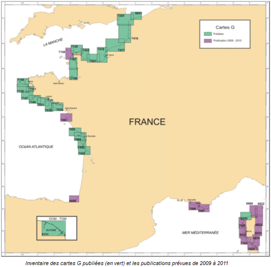
Following international cartographic research, it became apparent that in 1987 the French Hydrographic Office published the first world map of sedimentology. The Office took up this activity again in 1992, which has led to the publication of 1 – 4 maps per year. As of March 2009, the catalogue is comprised of 28 G maps. To date the areas covered are the north coast of France, from Mont-Saint-Michel to the Belgian border, western and southern Brittany, the coasts from Charente maritime to Gironde, and northern Corsica. Annual sales are currently in the region of 1 500 and since the first G map was published in January 1993, 15 000 have been sold.
- Credit
-
Data producers: SHOM
- Status
- On going
- Point of contact
-
Organisation name Individual name Electronic mail address Role SHOM
Garlan Thierry
Local service desk
- Maintenance and update frequency
- Continual
- Maintenance note
-
Network duration : perennial network
- Theme
-
-
Sedimentology
-
Nature funds
-
Cartography
-
Data Compilation
-
Synthesis
-
Sedimentary facies
-
Sediment samples
-
-
GEMET - INSPIRE themes, version 1.0
-
-
Environmental monitoring facilities
-
-
Sous-regions marines
-
-
National
-
-
DCSMM : Type d'espace concerné
-
-
Pas d'espace particulier concerné
-
-
DCSMM : Descripteurs
-
-
D7: Hydrographical Conditions
-
-
DCSMM : Méthodes de recueil des données
-
-
Interprétation de cartographies
-
-
Thèmes Sextant
-
-
/Physical Environment/Geology/Seabed Nature
-
- Access constraints
- Other restrictions
- Other legal constraints
-
Restricted access
- Use limitation
-
Price : Cost of the product
- Spatial representation type
- Vector
- Denominator
- 50000
- Language
- Français
- Character set
- UTF8
- Topic category
-
- Oceans
))
- Supplemental Information
-
Project leader :
SHOM 1992
Prime contractor :
SHOM
Backers :
SHOM
Ifremer 2009
- Reference system identifier
- EPSG / WGS 84 (EPSG:4326) / 7.9
- Topology level
- Geometry only
- Geometric object type
- Complex
- Geometric object count
- 0
- OnLine resource
-
Protocol Linkage Name WWW:LINK
https://sextant.ifremer.fr/documentation/dcsmm/documents/Publications_cartes_G.doc Principales publications
- Hierarchy level
- Dataset
Conformance result
- Title
-
Inspire specifications
- Date (Creation)
- 2012-01-16
- Explanation
-
Non assessed
- Pass
- Statement
-
December 1992 : publication of first G map (Le Havre)
Number of observation or measurement points: on average 2000 old data (depth sounding) and 60 recent data (grabs) per map.
In order to obtain optimum accuracy, all existing data relating to the area to be mapped is used. A long period of research is necessary and requires investigation in the archives, databases (SISMER, BRGM, etc.) and with universities (Bordeaux, Brest, Caen, Rouen, Lille, etc.) and public or private external organisations (CREOCEAN, ODEM, Corsica’s Environment Office, Charante Maritime general council, autonomous ports, etc.). All data is analysed, validated, digitised (in the case of analogue data), and input into the BDSS.
According to the quantity and quality of available information, the reliability of the nature of the sea floor recorded is more or less accurate. When presented with conflicting data for one locations, the most recent is taken to be the most reliable, except when the measurement was take in exceptional circumstances (for example after a violent storm) or with an unreliable method (dredging).
- Description
-
Data Type : Geology
Hydrography
Specific information about data type :
Sedimentology
Bathymetry
Parameter(s) observed or measured :
Nature of the sea floor
Water depth
Parameter Resolution: 1/50000e
Current Tables
Update frequency : Variable
- Description
-
Sampling programme: Spatial, Stratified
- Description
-
Associated information: BDBS
Metadata
- File identifier
- 81fb10cd-1523-4a12-b473-ac64bc1c8eba
- Metadata language
- Français
- Other language
-
Language Character encoding English
- Character set
- UTF8
- Parent identifier
-
Base de Données Sédimentologiques du SHOM - BDSS -
52b3fb36-6101-4b10-a0ce-4ba82403f0d6
- Hierarchy level
- Series
- Date stamp
- 2024-04-05T08:09:03.134Z
- Metadata standard name
-
ISO 19115:2003/19139 - SEXTANT
- Metadata standard version
-
1.0
- Metadata author
-
Organisation name Individual name Electronic mail address Role Sextant
Local service desk
accessData
Overviews
)))