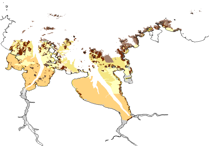
Map of intertidal habitats for the Natura 2000 FR5300015 site – Morlaix Bay
Map of intertidal habitats for the site Natura 2000 FR5300015 Bay of Morlaix was produced by the Marine Environmental Sciences Laboratory (LEMAR) of the Institut Universitaire Européen de la Mer (IUEM) as part of the European Natura 2000 network, and also by Ifremer Rebent project.
It reflects both the arial imagery interpretation (ortholitorales 2000, blom imaging from 2008) and field validations conducted between 2008 and 2010.
Habitat classification follows the Rebent typology (new proposals of 2009 and 2011).
Simple
- Title
-
Map of intertidal habitats for the Natura 2000 FR5300015 site – Morlaix Bay
- Alternate title
-
BMO_Natura_Habitats_ZSC_V0r1
- Date (Publication)
- 2010-11-02T10:09:00
- Citation identifier
- FR-330-715-368-00032-BMO_Natura_Habitats_ZSC_V1r1
- Presentation form
- Digital map
- Abstract
-
Map of intertidal habitats for the site Natura 2000 FR5300015 Bay of Morlaix was produced by the Marine Environmental Sciences Laboratory (LEMAR) of the Institut Universitaire Européen de la Mer (IUEM) as part of the European Natura 2000 network, and also by Ifremer Rebent project.
It reflects both the arial imagery interpretation (ortholitorales 2000, blom imaging from 2008) and field validations conducted between 2008 and 2010.
Habitat classification follows the Rebent typology (new proposals of 2009 and 2011).
- Purpose
-
The goal of this work is the cartographic habitat characterization of the Natura 2000 Special Area of Conservation (SAC) site in the Bay of Morlaix.
- Credit
-
LEMAR, IFREMER, REBENT
- Status
- On going
- Point of contact
-
Organisation name Individual name Electronic mail address Role Ifremer
Touria Bajjouk
Local service desk DREAL Bretagne
Michel Ledard
Local service desk Laboratoire LEMAR
Stevenn Lamarche
Product manager Ifremer
Claire Rollet
Product manager Ifremer
Ronan Loarer
Product manager
- Maintenance and update frequency
- Not planned
-
Thèmes Sextant
-
-
/Biological Environment/Habitats
-
- Theme
-
-
Habitat, Intertidal, Typology, Natura 2000, Cartography, Habitats guide, Intertidal zone
-
Données ouvertes
-
Open Data
-
- Place
-
-
France, Brittany, Finistère, Morlaix, Morlaix Bay
-
-
GEMET - INSPIRE themes, version 1.0
-
-
Habitats and biotopes
-
-
external.theme.gemet
-
-
habitat
-
-
Type de jeux de donnée ODATIS
-
-
/Processed data/Composite products
-
-
Thématiques - SIMM
-
-
/Etat du Milieu/Habitats
-
-
Sous-regions marines
-
-
Celtic Seas
-
-
Ocean Hackathon - Ville
-
-
Brest
-
- Use limitation
-
Commercial use is prohibited. Change and distribution of data prohibited without the consent of the distributor.
- Access constraints
- Other restrictions
- Use constraints
- Copyright
- Other legal constraints
-
Required citation in the bibliography: "LAMARCHE S., 2010. Cartographie des habitats benthiques du site Natura 2000 de la Baie de Morlaix" 15 p. and LOARER, R., ROLLET C. ; 2011. Réseau de surveillance benthique. Région Bretagne. Approche sectorielle intertidale. Cartographie des habitats benthiques intertidaux, Secteur de Morlaix. DYNECO/AG/11-07/RL. 50 p. + annexes
- Use limitation
-
unknown conditions
- Spatial representation type
- Vector
- Denominator
- 5000
- Language
- Français
- Character set
- UTF8
- Topic category
-
- Biota
- Environment description
-
ArcGIS 10.0 SP3
))
- Supplemental Information
-
- SITE: name of the Natura 2000 site
- ZONE: name field areas of the site
- METHOD_NUM: method used for scanning
- SUPP_NUM: Scan media
- DATE_SUPP: date of digital file
- NOM_AUT: name of the polygon's author
- ORG_AUT: organization of the polygon's author
- COM_NUM: miscellaneous comments on polygon digitization
- VALIDATION: specifies whether the polygon has been validated
- METHOD_VAL: specifies the method used to validate
- DATE_VAL: date validation
- NOM_VAL: name of polygon's validator
- PRENOM_VAL: first name of the polygon's validator
- ORG_VAL: Orgisation of polygon's validator
- COM_VAL: various comment on the validation
- CI: confidence index of the polygon (from 1 to 3)
- COD_EUR27: generic habitat code
- LIB_EUR27: generic habitat label
- THEM_EUR27: dominant generic habitat label for a simplified symbology (without mosaic, unrestricted in terms of levels)
- COD_CH2004: elementary habitat codes (habitats guide 2004)
- LIB_CH2004: elementary habitat's label (habitats guide 2004)
- THEM_CH04: dominant elementary habitat's label for a simplified symbology (without mosaic, unrestricted in terms of levels)
- LIB_NP09N1: Level 1 habitat label with the new proposed mapping typology (version 2011).
- THEM_NIV1: Level 1 dominant habitat with the new proposed mapping typology (version 2011).
- LIB_NP09N2: Level 2 habitat label with the new proposed mapping typology(version 2011).
- THEM_NIV2: Level 2 dominant habitat with the new proposed mapping typology (version 2011).
- LIB_NP09N3: Level 3 habitat label with the new proposed mapping typology (version 2011).
- THEM_NIV3: Level 3 dominant habitat with the new proposed mapping typology (version 2011).
- SUBSTRAT : description of the nature of the substrate corresponding to the polygon
- BIOCENOSE : description of the biota present in the area bounded by the polygon
- SURF_M2 : surface of the polygon m²
- SURF_HA : surface of the polygon ha (hectare)
- COMMENT : How to; Additional information
- Reference system identifier
- 4326
- Topology level
- Geometry only
- Geometric object type
- Surface
- Geometric object count
- 2661
Distributor
- Distributor contact
-
Organisation name Individual name Electronic mail address Role Ifremer - Centre de Brest
Administrateur du serveur Sextant
Dissemination Unit
- Distributor format
-
Name Version ESRI Shapefile
10.0
- OnLine resource
-
Protocol Linkage Name OGC:WMS
https://sextant.ifremer.fr/services/wms/biologie IFR_NATURA2000_ZSC_BMO_HAB_P
FILE
IFR_NATURA2000_ZSC_BMO_HAB_P
OGC:WFS
https://sextant.ifremer.fr/services/wfs/biologie IFR_NATURA2000_ZSC_BMO_HAB_P
- Hierarchy level
- Dataset
Conformance result
- Title
-
Inspire
- Date (Publication)
- 2010-05-03
- Explanation
-
Non évalué
- Pass
- Statement
-
This study was conducted from multiple shapefiles provided by Ifremer
- Delimitation of the Natura 2000 FR5300015 site at the Bay of Morlaix, entitled "AncienneEmpriseNatura2000Lb93.shp"
- The SHOM coastline, in the study area entitled "TraitCoteShom25_extrait.shp"
- Delimitation of the area conducted by Ifremer at Térénez entitled "Emprise_Terenez_rebent.shp" and that of the subtidal area entitled "carte_AEhrhold_morlaix_emprise_approxlb93.shp."
Other files allowed for additional information, such as the one on Brittany seagrass "ifr_suiviHerbier_Bretagne2007_l93.shp"
There are three raster images used for habitat photo-interpretation:
Ortholittorales-2000 (dalle40.ecw and dalle41.ecw), available online on the GeoPortal,
- BD Ortho 2005 (29-2005-0130-2420-LA2E-C07.ecw to 29-2005-0145-2435-LA2E-C07.ecw), belonging to the GEOMER laboratory, in partnership with the CETE Normandy
- Blom-2008 (morlaix_mos_extrait.img) belonging to Ifremer
Metadata
- File identifier
- 833a8bc5-5647-4989-8087-538cd309d2d1
- Metadata language
- Français
- Other language
-
Language Character encoding English
- Character set
- UTF8
- Hierarchy level
- Dataset
- Date stamp
- 2020-06-04T00:36:00
- Metadata standard name
-
ISO 19115:2003/19139 - SEXTANT
- Metadata standard version
-
1.0
- Metadata author
-
Organisation name Individual name Electronic mail address Role Ifremer
Julie TOUROLLE
Local service desk
accessData
Overviews
)))