SMOOVE, video data from EMSO-Azores observatory, 2011-12
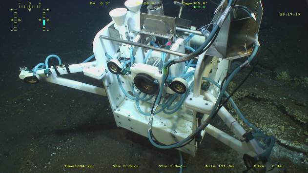
This dataset contains video data acquired with the camera SMOOVE installed on the TEMPO ecological module, deployed on the EMSO-Azores observatory from June 2011 to July 2012. Data consist in two minutes video sequences recorded every 6 hours. Due to technical issues in the recording, the dataset is incomplete from April 2011 to July 2012. The instrument is connected to the Seamon East environmental monitoring node and films a mussel bed located at the base of the Tour Eiffel edifice at 1695m depth.
Simple
- Title
-
SMOOVE, video data from EMSO-Azores observatory, 2011-12
- Date (Publication)
- 2015-05-22T00:00:00
- Citation identifier
- 847c1d1a-7fc0-4132-bb00-ede3cdd85e0f
- Abstract
-
This dataset contains video data acquired with the camera SMOOVE installed on the TEMPO ecological module, deployed on the EMSO-Azores observatory from June 2011 to July 2012. Data consist in two minutes video sequences recorded every 6 hours. Due to technical issues in the recording, the dataset is incomplete from April 2011 to July 2012. The instrument is connected to the Seamon East environmental monitoring node and films a mussel bed located at the base of the Tour Eiffel edifice at 1695m depth.
- Status
- On going
- Point of contact
-
Organisation name Individual name Electronic mail address Role Ifremer, Institut Carnot EDROME, France
Sarrazin Jozée
Author Ifremer, Institut Carnot EDROME, France
Sarradin Pierre-Marie
Author Ifremer, Institut Carnot EDROME, France
Legrand Julien
Author CNRS, IPGP, France
Cannat Mathilde
Author Sismer
Publisher
- Maintenance and update frequency
- As needed
- Keywords
-
-
Mid-Atlantic Ridge
-
EMSO-Açores
-
Hydrothermal Vents
-
Lucky Strike
-
Marine imagery
-
TEMPO
-
Time-series
-
MoMAR
-
MoMARSAT2011
-
Bathymodiolus azoricus assemblage
-
Tour Eiffel
-
- Access constraints
- Other restrictions
- Other legal constraints
-
EMSO data are published without any warranty, express or implied. The user assumes all risk arising from his/her use of EMSO data. EMSO data are intended to be research-quality and include estimates of data quality and accuracy, but it is possible that these estimates or the data themselves contain errors. It is the sole responsibility of the user to assess if the data are appropriate for his/her use, and to interpret the data, data quality, and data accuracy accordingly. EMSO welcomes users to ask questions and report problems to the contact addresses listed in the data files or on the EMSO web page.
- Spatial representation type
- Grid
- Language
- English
- Character set
- UTF8
- Topic category
-
- Oceans
))
- Begin date
- 2011-07-20T00:00:00
- End date
- 2012-03-29T00:00:00
- Reference system identifier
- EPSG / WGS 84 (EPSG:4326) / 7.9
- Topology level
- Geometry only
- Geometric object type
- Point
- Geometric object count
- 1000000000
- Distribution format
-
Name Version
- OnLine resource
-
Protocol Linkage Name WWW:DOWNLOAD-1.0-link--download
ftp://ftp.ifremer.fr/ifremer/doi/emso-azores/2011/video2011-2012.tar
- OnLine resource
-
Protocol Linkage Name WWW:LINK-1.0-http--metadata-URL
http://dx.doi.org/10.12770/847c1d1a-7fc0-4132-bb00-ede3cdd85e0f DOI du jeu de donnée
- OnLine resource
-
Protocol Linkage Name WWW:LINK
http://dx.doi.org/10.17600/11030070 Oceonographic cruise : MOMARSAT2011
- Hierarchy level
- Dataset
Conformance result
- Title
-
Inspire specifications
- Date (Creation)
- 2012-01-16
- Explanation
-
Non évalué
- Pass
Metadata
- File identifier
- 847c1d1a-7fc0-4132-bb00-ede3cdd85e0f
- Metadata language
- English
- Character set
- UTF8
- Hierarchy level
- Dataset
- Date stamp
- 2020-06-04T00:27:59
- Metadata standard name
-
ISO 19115:2003/19139 - SEXTANT
- Metadata standard version
-
1.0
- Metadata author
-
Organisation name Individual name Electronic mail address Role Ifremer
Local service desk
accessData
Overviews
)))