EEA marine assessment grid, Jan. 2017
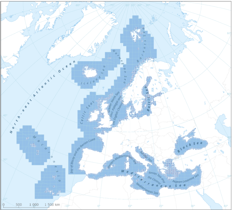
This metadata refers to the EEA marine assessment grid, to which all data and assessment results have been spatially mapped in order to ensure that data can be compared in a uniform way across the European regional seas.
The marine assessment grid is based on the EEA reference grid system. The EEA reference grid is based on ERTS89 Lambert Azimuthal Equal Area projection with parameters: latitude of origin 52° N, longitude of origin 10° E, false northing 3 210 000.0 m, false easting 4 321 000.0 m. All grid cells are named with a unique identifier containing information on grid cell size and the distance from origin in meters (easting and northing). An important attribute of the EEA reference grid system is that by using an equal area projection all grid cells are having the same area for the same grid size.
In this marine assessment grid, two grid sizes are used:
* 100 x 100 km in offshore areas (> 20 km from the coastline)
* 20 x 20 km in coastal areas (<= 20 km from the coastline)
The grid sizes were choosen after an evaluation of data availability versus the need for sufficient detail in the resulting assessment. The resulting assessment grid is a combination of two grid sizes using the EEA reference grid system.
The overall area of interest used in the grid is based on the marine regions and subregions under the Marine Strategy Framework Directive (MSFD). Additionally, Norwegian (Barent Sea and Norwegian Sea) and Icelandic waters (’Iceland Sea’) have been added (see Surrounding seas of Europe). Note that, within the North East Atlantic region, only the subregions within EEZ boundaries (~200 nm) have been included.
Simple
- Title
-
EEA marine assessment grid, Jan. 2017
- Date (Creation)
- 2021-06-24
- Edition
-
01.00
- Citation identifier
- eea_v_3035_100_km_marine-assessment-grid_p_2017_v01_r00
- Abstract
-
This metadata refers to the EEA marine assessment grid, to which all data and assessment results have been spatially mapped in order to ensure that data can be compared in a uniform way across the European regional seas.
The marine assessment grid is based on the EEA reference grid system. The EEA reference grid is based on ERTS89 Lambert Azimuthal Equal Area projection with parameters: latitude of origin 52° N, longitude of origin 10° E, false northing 3 210 000.0 m, false easting 4 321 000.0 m. All grid cells are named with a unique identifier containing information on grid cell size and the distance from origin in meters (easting and northing). An important attribute of the EEA reference grid system is that by using an equal area projection all grid cells are having the same area for the same grid size.
In this marine assessment grid, two grid sizes are used:
* 100 x 100 km in offshore areas (> 20 km from the coastline)
* 20 x 20 km in coastal areas (<= 20 km from the coastline)
The grid sizes were choosen after an evaluation of data availability versus the need for sufficient detail in the resulting assessment. The resulting assessment grid is a combination of two grid sizes using the EEA reference grid system.
The overall area of interest used in the grid is based on the marine regions and subregions under the Marine Strategy Framework Directive (MSFD). Additionally, Norwegian (Barent Sea and Norwegian Sea) and Icelandic waters (’Iceland Sea’) have been added (see Surrounding seas of Europe). Note that, within the North East Atlantic region, only the subregions within EEZ boundaries (~200 nm) have been included.
- Point of contact
-
Organisation name Individual name Electronic mail address Role European Environment Agency
Local service desk European Environment Agency
Production center
- Maintenance and update frequency
- Not planned
- Keywords
-
- Keywords
-
-
GEMET
-
-
gridding
-
environmental assessment
-
marine environment
-
-
Continents, countries, sea regions of the world.
-
-
Northeast Atlantic Ocean (40W)
-
Black Sea
-
North Sea
-
Barents Sea
-
Celtic Sea
-
Bay of Biscay
-
English Channel
-
Norwegian Sea
-
Mediterranean Sea
-
Baltic Sea
-
Iceland Sea
-
-
Spatial scope
-
-
European
-
-
Sous-regions marines
-
-
/Métropole
-
/Métropole/Manche mer du Nord
-
/Métropole/Mers Celtiques
-
/Métropole/Golfe de Gascogne
-
/Métropole/Méditerranée occidentale
-
-
Thématiques - SIMM
-
-
/Etat du Milieu/Littoral
-
-
Type de jeux de donnée - ODATIS
-
-
/Données administratives
-
-
Type de jeux de donnée - ODATIS
-
-
/Données dérivées/Références statistiques
-
-
Cadre Réglementaire - SIMM
-
-
Directive Cadre Stratégie pour le Milieu Marin (DCSMM)
-
- Access constraints
- Other restrictions
- Other legal constraints
- no limitations to public access
- Use constraints
- Other restrictions
- Other legal constraints
-
EEA standard re-use policy: unless otherwise indicated, re-use of content on the EEA website for commercial or non-commercial purposes is permitted free of charge, provided that the source is acknowledged (http://www.eea.europa.eu/legal/copyright). Copyright holder: European Environment Agency (EEA).
- Spatial representation type
- Vector
- Distance
- 20 km
- Distance
- 100 km
- Language
- English
- Topic category
-
- Location
- Geoscientific information
))
- Begin date
- 2017-01-01
- End date
- 2017-12-31
- Unique resource identifier
- EPSG:3035
- Distribution format
-
Name Version SHP
- OnLine resource
- Hierarchy level
- Dataset
Conformance result
- Title
-
Commission Regulation (EU) No 1089/2010 of 23 November 2010 implementing Directive 2007/2/EC of the European Parliament and of the Council as regards interoperability of spatial data sets and services
- Date (Publication)
- 2010-12-08
- Explanation
-
See the referenced specification
- Statement
-
The assessment grid is build on the the EEA reference grid system. The EEA reference grid is based on ERTS89 Lambert Azimuthal Equal Area projection with parameters: latitude of origin 52° N, longitude of origin 10° E, false northing 3 210 000.0 m, false easting 4 321 000.0 m. All grid cells are named with a unique identifier containing information on grid cell size and the distance from origin in meters (easting and northing). The method followed the instructions for the EEA fishnet tool described in the EEA GIS guideline available from http://www.eionet.europa.eu/gis.
The following procedure was carried out when making the assessment grid: the coastal 20 x 20 km grid cells were identified by the distance of their mid point from the coastline (<= 20 km). All the 20 x 20 km grid cells located with the midpoint within 20 km distance from the coastline were included. For the remaining area of interest, the 100 x 100 km grid cells were included. For 100 x100 km grid cells partly covered by 20 x 20 km grid cells only the exclusive non-overlapping part of the 100 x 100 km grid cells were included. For this reason, their areas are smaller than a non-modified 100 x 100 km grid cell. This was done to avoid overlaps in the assessment grid. In coastal areas, grid cells were included if their midpoint was within 20 km from the coast. The resulting combined assessment grid fills the entire area of interest with grid cells without gaps and overlaps.
More information is provided in the document "Supplementary online material to EEA Report No 25/2018 Contaminants in Europe’s seas", available at: https://www.eea.europa.eu/publications/contaminants-in-europes-seas/annex/.
Metadata
- File identifier
- 84d1f816-1913-45b1-94b7-a5721a18296c
- Metadata language
- English
- Character set
- UTF8
- Hierarchy level
- Dataset
- Date stamp
- 2022-04-21T06:33:30.171Z
- Metadata standard name
-
ISO 19115/19139
- Metadata standard version
-
1.0
- Metadata author
-
Organisation name Individual name Electronic mail address Role European Environment Agency
Local service desk
Record from EEA

accessData
Overviews
)))