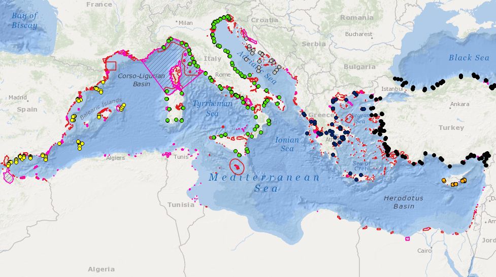
MEDSEA_CH2_Product_6 / The monitoring capacity of biodiversity in MPAs
Combination MPAs and monitoring stations for biodiversity elements
Simple
Identification info
- Date (Creation)
- 2016-12-09T00:00:00
- Date (Revision)
- 2016-12-13T00:00:00
- Citation identifier
- DOI:10.12770/88118f24-3402-4935-843a-d4842d032483
- Issue identification
-
MEDSEA D3.3.5
- Purpose
-
The monitoring capacity of biodiversity in MPAs
- Credit
-
EMODnet Medsea Checkpoint
- Point of contact
-
Organisation Individual Electronic mail address ORCID Role HCMR
Point of contact EMODnet Medsea Checkpoint
Publisher HCMR
Sofia Reizopoulou
Author HCMR
Chara Kyriakidou
Author
- Spatial representation type
- Vector
- Topic category
-
- Oceans
Extent
))
Extent
- Time period
- 1987-01-01T00:00:00 2014-12-31T00:00:00
Vertical element
- Minimum value
- 0
- Maximum value
- 100
- Used by challenges
-
-
MedSea - CH02 - Marine Protected Areas
-
- Processing level of characteristics
-
-
High level analyzed
-
- Production mode
-
-
Delayed
-
- GEMET - INSPIRE themes, version 1.0
-
-
Bio-geographical regions
-
- Theme
-
-
Marine Protected Areas
-
MPAs
-
Biodiversity
-
Monitoring stations
-
Mediterranean
-
Resource constraints
- Use constraints
Associated resource
- Association Type
- Cross reference
- Initiative Type
- specification
- Metadata Reference
Associated resource
- Association Type
- Cross reference
- Initiative Type
- upstreamData
Associated resource
- Association Type
- Cross reference
- Initiative Type
- upstreamData
- Language
- English
- Character encoding
- UTF8
Distribution Information
- Distribution format
-
-
ESRI Shapefile
-
- OnLine resource
-
DOI of the product
DOI of the product
- OnLine resource
-
CH2_product_6
Product visualization
MEDSEA_CH2_Product_6 / The monitoring capacity of biodiversity in MPAs - The monitoring capacity of biodiversity in MPAs
- Begin date
- 1987-01-01T00:00:00
- End date
- 2014-12-31T00:00:00 After
Vertical element
- Minimum value
- 0
- Maximum value
- 100
Reference System Information
- Reference system identifier
- http://www.opengis.net/def/crs/EPSG/0/4326
- Reference system type
- Geodetic Geographic 2D
Metadata
- Metadata identifier
- urn:uuid/88118f24-3402-4935-843a-d4842d032483
- Language
- English
- Character encoding
- UTF8
Type of resource
- Resource type
- Dataset
- Metadata linkage
-
http://localhost:8080/geonetwork/srv/eng//metadata/286d8887-58a5-4562-a0b9-a69b78fced76
- Metadata linkage
-
http://localhost:8080/geonetwork/srv/eng//metadata/47dea01f-5b6a-48d7-990a-606a6001cbef
- Metadata linkage
-
https://sextant.ifremer.fr/geonetwork/srv/eng//metadata/88118f24-3402-4935-843a-d4842d032483
- Metadata linkage
-
https://sextant.ifremer.fr/geonetwork/srv/fre//metadata/88118f24-3402-4935-843a-d4842d032483
- Date info (Revision)
- 2017-08-24T12:29:59Z
- Date info (Creation)
- 2005-03-31T19:13:30
Metadata standard
- Title
-
ISO 19115-3 - Emodnet Checkpoint - Targeted Data Product
accessData
Overviews
Spatial extent
)))