Sub-marine cables and pipelines listed by Shom used for MSFD
The product contains a description of submarine cables and pipelines brought to the attention of Shom on French areas of responsibility. These are 2D linear objects of the seabed that divide into two categories:
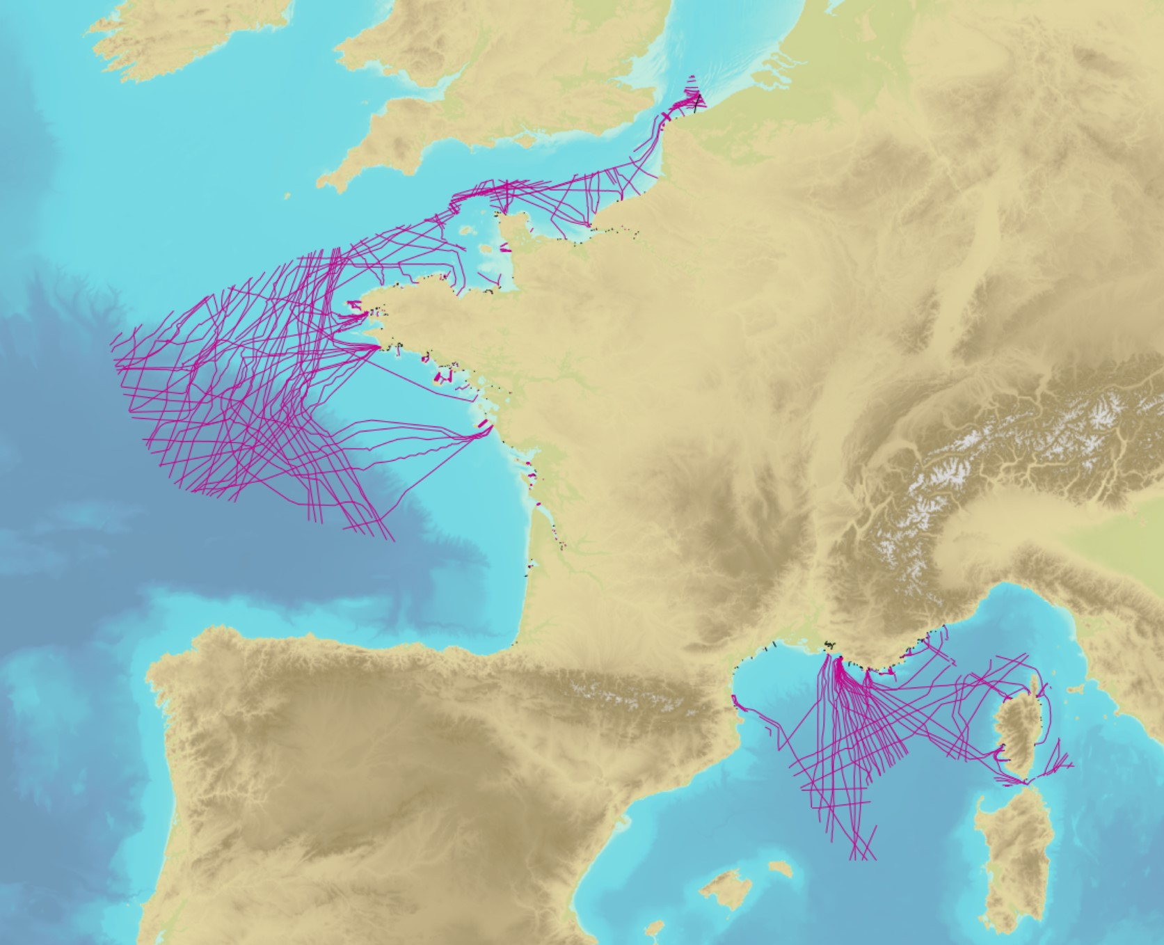
• The submarine cables: these are cables placed on the seabed where electricity or information (telecommunication) flows. They represent the vast majority of objects (more than 90%);
• Emissaries and submarine pipes: these are pipes that allow the discharge, sampling or circulation of fluids.
Simple
- Title
-
Sub-marine cables and pipelines listed by Shom used for MSFD
- Date (Creation)
- 1995-01-01
- Date (Revision)
- 2019-01-07
- Date (Publication)
- 2018-12-01
- Citation identifier
- http://www.shom.fr/BDML/CABLES
- Abstract
-
The product contains a description of submarine cables and pipelines brought to the attention of Shom on French areas of responsibility. These are 2D linear objects of the seabed that divide into two categories:
• The submarine cables: these are cables placed on the seabed where electricity or information (telecommunication) flows. They represent the vast majority of objects (more than 90%);
• Emissaries and submarine pipes: these are pipes that allow the discharge, sampling or circulation of fluids.
- Credit
-
©Shom
- Point of contact
-
Organisation name Individual name Electronic mail address Role Shom
Author Shom
Publisher
-
Type de jeux de donnée ODATIS
-
-
/Processed data/Reference datasets
-
-
Sous-regions marines
-
-
/Metropolitan France/Bay of Biscay
-
/Metropolitan France/Channel-North Sea
-
/Metropolitan France/Western Mediterranean
-
/Metropolitan France/Celtic Seas
-
/France
-
-
Thématiques - SIMM
-
-
/Uses and Human Activities/Shipping and Ports
-
/Uses and Human Activities/Urbanisation and Artificialisation
-
- Theme
-
-
MSFD
-
INSPIRE priority data set
-
- Place
-
-
France
-
-
DCSMM : Descripteurs
-
-
D7: Hydrographical Conditions
-
- Use limitation
-
Public license Creative Commons Attribution-ShareAlike 4.0 International (CC BY-SA 4.0)
- Use limitation
-
Do not use for navigation
- Use limitation
-
Public license Creative Commons Attribution-ShareAlike 4.0 International (CC BY-SA 4.0)
- Access constraints
- License
- Use constraints
- Other restrictions
- Other legal constraints
-
Public license Creative Commons Attribution-ShareAlike 4.0 International (CC BY-SA 4.0)
- Access constraints
- Other restrictions
- Other legal constraints
- No public access restrictions.
- Classification
- Unclassified
- Spatial representation type
- Vector
- Language
- Français
- Character set
- UTF8
- Topic category
-
- Utilities communication
))
- Unique resource identifier
- WGS 84 (EPSG:4326)
- Distribution format
-
Name Version SHP
inapplicable
GML
3.2
- Distributor contact
-
Organisation name Individual name Electronic mail address Role Shom
Dissemination Unit
- OnLine resource
-
Protocol Linkage Name WWW:LINK-1.0-http--link
https://data.shom.fr Shom Geoportal
OGC Web Map Service https://services.data.shom.fr/INSPIRE/wms/v?service=WMS&request=GetCapabilities&version=1.3.0 CABLES_BDD_WLD_WGS84G_WMS
- OnLine resource
-
Protocol Linkage Name WWW:LINK-1.0-http--metadata-URL
https://doi.org/10.12770/8baa9c7a-86d2-403f-bb92-3ab6843cb37a Digital Object Identifier (DOI)
- Hierarchy level
- Dataset
Conformance result
- Title
-
Commission Regulation (EU) No 1089/2010 of 23 November 2010 implementing Directive 2007/2/EC of the European Parliament and of the Council as regards interoperability of spatial data sets and services
- Date (Publication)
- 2010-11-23
- Explanation
-
Information sur la conformité au règlement d'interopérabilité des séries et des services de données géographiques.
- Pass
Conformance result
- Title
-
INSPIRE Data Specification on Utility and Government Services – Technical Guidelines v3.0
- Date (Publication)
- 2013-12-10
- Explanation
-
Information sur la conformité de la ressource à une spécification.
- Pass
- Statement
-
Shom lists data based on the information provided by operators and professionals.
Metadata
- File identifier
- 8baa9c7a-86d2-403f-bb92-3ab6843cb37a
- Metadata language
- Français
- Other language
-
Language Character encoding English UTF8
- Character set
- UTF8
- Hierarchy level
- Dataset
- Hierarchy level name
-
Produit
- Date stamp
- 2023-12-11T16:16:15.817Z
- Metadata standard name
-
ISO 19115:2003/19139
- Metadata standard version
-
1.0
- Metadata author
-
Organisation name Individual name Electronic mail address Role Shom
Local service desk
accessData
Overviews
)))