Monitoring System in the Loire Estuary - SYVEL 2007 -
Monitoring System in the Loire Estuary SYVEL 2007 -
Simple
- Title
-
Monitoring System in the Loire Estuary - SYVEL 2007 -
- Date (Creation)
- 2007-01-01T00:00:00
- Citation identifier
- FR-DCSMM-PDS-BD_SYVEL
- Presentation form
- Digital profile
- Abstract
-
Monitoring System in the Loire Estuary SYVEL 2007 -
- Purpose
-
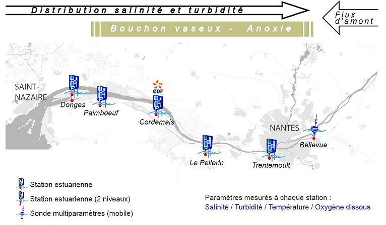
This network of continuous measurements in the Loire estuary was developed in order to monitor the estuary system and to add a spatial and temporal description of increased salinity, turbidity, anoxia and temperature changes. In this way, it meets long-term monitoring needs for understanding estuary processes, and also promotes improvement and optimisation of water uses.
This network is made up of 5 stations distributed along the Loire estuary, between Nantes and Paimboeuf, therefore enabling us to monitor changes in the water’s main subsurface physio-chemical parameters: temperature, salinity (via conductivity), oxygen content and a estimation of the concentration of materials in suspension (measured via turbidity).
A sixth station was added further upstream, in Donges. This station has a second measurement point, 4m below the surface.
- Credit
-
Data producers : GIP Loire Estuaire, EDF
- Status
- On going
- Point of contact
-
Organisation name Individual name Electronic mail address Role Loire Estuaire
BERTIER Christine
Local service desk
- Maintenance and update frequency
- Continual
- Maintenance note
-
Network duration : perennial network
- Theme
-
-
Network
-
Automated measurements
-
Loire
-
Coast
-
Temperature
-
Salinity
-
Turbidity
-
Oxygen Content
-
-
GEMET - INSPIRE themes, version 1.0
-
-
Environmental monitoring facilities
-
-
Sous-regions marines
-
-
Bay of Biscay
-
-
DCSMM : Type d'espace concerné
-
-
Pas d'espace particulier concerné
-
-
DCSMM : Descripteurs
-
-
D9: Health Issues
-
D8: Chemical contaminants
-
-
DCSMM : Méthodes de recueil des données
-
-
Observation directe
-
Observation par point
-
-
Thèmes Sextant
-
-
/Chemical Environment/Water Column
-
- Access constraints
- Other restrictions
- Other legal constraints
-
Restricted access
- Use limitation
-
Use of this data is subject to conditions.
Any use of this data:
• Must not manipulate the data in any way,
• Must correctly reference the source of the data,
• Must take into account the characteristics of the data.
Any use of the data for commercial means is strictly prohibited.
Users must read and adhere to the detailed data usage guidelines (http:// loire-estuaire.org/dif/do/warning).
- Spatial representation type
- Vector
- Denominator
- 50000
- Language
- Français
- Character set
- UTF8
- Topic category
-
- Oceans
))
- Supplemental Information
-
Project leader :
GIP Loire Estuaire / EDF 2007
Prime contractor :
GIP Loire Estuaire / EDF 2007
Backer :
GIP Loire Estuaire / EDF 2007
- Reference system identifier
- EPSG / WGS 84 (EPSG:4326) / 7.9
- Topology level
- Geometry only
- Geometric object type
- Complex
- Geometric object count
- 0
- Hierarchy level
- Dataset
Conformance result
- Title
-
Inspire specifications
- Date (Creation)
- 2012-01-16
- Explanation
-
Non assessed
- Pass
- Statement
-
2007 : Implementation of the SYVEL measurement network.
December 2010 : Addition of a sixth station further upstream, in Donges. This station is equipped with a second measurement point, 4m below the surface.
The specifics of a continuous measurement system in an estuary environment (high rates of turbidity, salinity, living organisms, etc.)
mean the sensors are at risk of becoming clogged, which would hinder the network’s functioning capacity.
These elements led us to retain the use of two measurement systems, depending on the site of the station:
• Measurement by multi-parameter sounders
• measurement by estuary station ( http://www.loire-estuaire.org/dif/ pdf/station_estuarienne_fr.pdf)
The data visible on the website is unvalidated. One first weekly validation is conducted in order to remove obvious outliers.
Complete validation takes place around every three months, one the sensors are calibrated.
- Description
-
Data type :
Hydrology
Measured or observed parameters :
Temperature
Conductivity
Turbidity
Oxygen content
Parameters resolution :
Measurement range : -5°C to 30 °C Accuracy : +/- 0.1 °C Measurement range : 0 to 70 mS/cm Accuracy : +/- 0.3 mS/cm
Measurement range : 0-9999 NTU Accuracy : +/- 10% of the full scale
Measurement range : 0 to 20 ppm in mg/L Accuracy : +/- 0,2 ppm in mg/L
Observation frequency : 30 min until 2010 then 10 to 15 min 1h for the Cordemais station
- Description
-
Sampling method :
Spatial
- Description
-
Father device : SYMEL (Système de Mesure dans l'Estuaire de la
Loire) network managed by GPMNSN and EDF in the 90s
Metadata
- File identifier
- 8c72ee86-d038-48be-8da0-0fe382386bfe
- Metadata language
- Français
- Other language
-
Language Character encoding English
- Character set
- UTF8
- Hierarchy level
- Series
- Date stamp
- 2020-06-04T00:36:32
- Metadata standard name
-
ISO 19115:2003/19139 - SEXTANT
- Metadata standard version
-
1.0
- Metadata author
-
Organisation name Individual name Electronic mail address Role Sextant
Local service desk
accessData
Overviews
)))