Bathymetry - Lesser Antilles volcanic arc (synthesis, 2025)
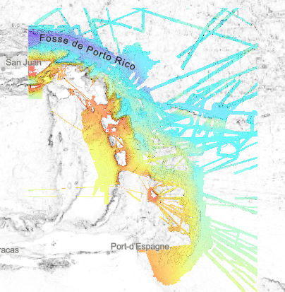
Bathymetry of the Lesser Antilles volcanic arc, at a spatial resolution of 1/16 arc minute. This Digital Terrain Model is a compilation of multibeam echosounders data.
Restriction : the DTM largely overlaps national EEZ. The entire product cannot be freely disseminated.
Processing : Since the beginning of the 1990s, the scientific exploration of the West Indian arc has provided the opportunity for regular acquisition of multibeam bathymetry. About twenty scientific cruises and valued transits feed a remarkable database and offer a wide bathymetric coverage of this geological structure. They were assembled to produce a bathymetric model of the entire region.
The final product is a double dataset : a raster at 1/16 minute steps (~ 100 m) of bathymetric data, and a shapefile that identify data sources.
Processing report : "Talbot Sophie (2019). Evaluation d'une méthodologie pour la compilation de données bathymétriques." https://w3.ifremer.fr/archimer/doc/00613/72480/
Cruises description :
- CAMBON Marie-Anne (2023) BICOSE 3 cruise, RV Pourquoi pas ?, https://doi.org/10.17600/18002399
- LOUBRIEU Benoit, ESCARTIN Javier (2023) TV_PTPBES 2023 cruise, RV Pourquoi pas ?, https://doi.org/10.17600/18003319
- KLINGELHOEFER Frauke, MARCAILLOU Boris (2023) MANTA-RAY 2 cruise, RV Pourquoi pas ?, https://doi.org/10.17600/18003188
- PELLETER Ewan, CATHALOT Cécile (2022) HERMINE2 cruise, RV Pourquoi pas ?, https://doi.org/10.17600/18001851
- LOUBRIEU Benoit, ESCARTIN Javier (2022) TV_HORPTP 2022 cruise, RV Pourquoi pas ?, https://doi.org/10.17600/18002950
- KLINGELHOEFER Frauke, MARCAILLOU Boris (2022) MANTA-RAY cruise, RV L'Atalante, https://doi.org/10.17600/18002498
- ESCARTIN Javier, LE FRIANT Anne, FEUILLET Nathalie (2017) SUBSAINTES cruise, RV L'Atalante, https://doi.org/10.17600/17001000
- MARCAILLOU Boris, KLINGELHOEFER Frauke (2016) ANTITHESIS 3 cruise, RV Pourquoi pas ?, https://doi.org/10.17600/16001700
- MARCAILLOU Boris, KLINGELHOEFER Frauke (2013) ANTITHESIS LEG1 cruise, RV L'Atalante, https://doi.org/10.17600/13010070
- FEUILLET Nathalie (2009) GWADASEIS cruise, RV Le Suroît, https://doi.org/10.17600/9020020
- LEBRUN Jean Frédéric (2009) KASHALLOW 2 cruise, RV Le Suroît, https://doi.org/10.17600/9020010
- LAIGLE Mireille, LEBRUN Jean Frédéric, HIRN Alfred (2007) SISMANTILLES 2 cruise, RV L'Atalante, https://doi.org/10.17600/7010020
- PATRIAT Martin (2007) ANTIPLAC cruise, RV L'Atalante, https://doi.org/10.17600/7010010
- DEPLUS Christine, BOUDON Georges (2002) CARAVAL cruise, RV L'Atalante, https://doi.org/10.17600/2010030
- MASCLE Alain (2002) CARAMBA cruise, RV L'Atalante, https://doi.org/10.17600/2010010
- DEPLUS Christine (1998) AGUADOMAR cruise, RV L'Atalante, https://doi.org/10.17600/98010120
- LE PICHON Xavier, LALLEMANT Siegfried (1992) MANON cruise, RV L'Atalante, https://doi.org/10.17600/92000211
Added value transits :
- Leve_smf (https://doi.org/10.17600/16010800),
- Lobestory (https://doi.org/10.17600/4010030),
- Guyaplac (https://doi.org/10.17600/3010050),
- TRtoufdf, transit from Toulon to Fort-de-France
- Dormasis (https://doi.org/10.17600/92000411),
- Faranaut/15N (https://doi.org/10.17600/92000311),
- Fara-Seadma1 (https://doi.org/10.17600/91004411),
- Fara
Published DTM :
- Ryan, W.B.F., S.M. Carbotte, J.O. Coplan, S. O'Hara, A. Melkonian, R. Arko, R.A. Weissel, V. Ferrini, A. Goodwillie, F. Nitsche, J. Bonczkowski, and R. Zemsky (2009), Global Multi-Resolution Topography synthesis, Geochem. Geophys. Geosyst., 10, Q03014, doi: 10.1029/2008GC002332
Simple
- Title
-
Bathymetry - Lesser Antilles volcanic arc (synthesis, 2025)
- Date (Creation)
- 2020-03-10T14:00:00
- Date (Revision)
- 2025-03-04
- Citation identifier
- FR-330715-368-00032-Synthese_ArcAntillais_1_16min_BATHY
- Citation identifier
- DOI:10.12770/915d04a1-220f-4784-934c-c269a515e5a9
- Cited responsible party
-
Organisation name Individual name Electronic mail address Role Ifremer
Géosciences Marines
Local service desk
- Presentation form
- Digital map
- Abstract
-
Bathymetry of the Lesser Antilles volcanic arc, at a spatial resolution of 1/16 arc minute. This Digital Terrain Model is a compilation of multibeam echosounders data.
Restriction : the DTM largely overlaps national EEZ. The entire product cannot be freely disseminated.
Processing : Since the beginning of the 1990s, the scientific exploration of the West Indian arc has provided the opportunity for regular acquisition of multibeam bathymetry. About twenty scientific cruises and valued transits feed a remarkable database and offer a wide bathymetric coverage of this geological structure. They were assembled to produce a bathymetric model of the entire region.
The final product is a double dataset : a raster at 1/16 minute steps (~ 100 m) of bathymetric data, and a shapefile that identify data sources.
Processing report : "Talbot Sophie (2019). Evaluation d'une méthodologie pour la compilation de données bathymétriques." https://w3.ifremer.fr/archimer/doc/00613/72480/
Cruises description :
- CAMBON Marie-Anne (2023) BICOSE 3 cruise, RV Pourquoi pas ?, https://doi.org/10.17600/18002399
- LOUBRIEU Benoit, ESCARTIN Javier (2023) TV_PTPBES 2023 cruise, RV Pourquoi pas ?, https://doi.org/10.17600/18003319
- KLINGELHOEFER Frauke, MARCAILLOU Boris (2023) MANTA-RAY 2 cruise, RV Pourquoi pas ?, https://doi.org/10.17600/18003188
- PELLETER Ewan, CATHALOT Cécile (2022) HERMINE2 cruise, RV Pourquoi pas ?, https://doi.org/10.17600/18001851
- LOUBRIEU Benoit, ESCARTIN Javier (2022) TV_HORPTP 2022 cruise, RV Pourquoi pas ?, https://doi.org/10.17600/18002950
- KLINGELHOEFER Frauke, MARCAILLOU Boris (2022) MANTA-RAY cruise, RV L'Atalante, https://doi.org/10.17600/18002498
- ESCARTIN Javier, LE FRIANT Anne, FEUILLET Nathalie (2017) SUBSAINTES cruise, RV L'Atalante, https://doi.org/10.17600/17001000
- MARCAILLOU Boris, KLINGELHOEFER Frauke (2016) ANTITHESIS 3 cruise, RV Pourquoi pas ?, https://doi.org/10.17600/16001700
- MARCAILLOU Boris, KLINGELHOEFER Frauke (2013) ANTITHESIS LEG1 cruise, RV L'Atalante, https://doi.org/10.17600/13010070
- FEUILLET Nathalie (2009) GWADASEIS cruise, RV Le Suroît, https://doi.org/10.17600/9020020
- LEBRUN Jean Frédéric (2009) KASHALLOW 2 cruise, RV Le Suroît, https://doi.org/10.17600/9020010
- LAIGLE Mireille, LEBRUN Jean Frédéric, HIRN Alfred (2007) SISMANTILLES 2 cruise, RV L'Atalante, https://doi.org/10.17600/7010020
- PATRIAT Martin (2007) ANTIPLAC cruise, RV L'Atalante, https://doi.org/10.17600/7010010
- DEPLUS Christine, BOUDON Georges (2002) CARAVAL cruise, RV L'Atalante, https://doi.org/10.17600/2010030
- MASCLE Alain (2002) CARAMBA cruise, RV L'Atalante, https://doi.org/10.17600/2010010
- DEPLUS Christine (1998) AGUADOMAR cruise, RV L'Atalante, https://doi.org/10.17600/98010120
- LE PICHON Xavier, LALLEMANT Siegfried (1992) MANON cruise, RV L'Atalante, https://doi.org/10.17600/92000211
Added value transits :
- Leve_smf (https://doi.org/10.17600/16010800),
- Lobestory (https://doi.org/10.17600/4010030),
- Guyaplac (https://doi.org/10.17600/3010050),
- TRtoufdf, transit from Toulon to Fort-de-France
- Dormasis (https://doi.org/10.17600/92000411),
- Faranaut/15N (https://doi.org/10.17600/92000311),
- Fara-Seadma1 (https://doi.org/10.17600/91004411),
- Fara
Published DTM :
- Ryan, W.B.F., S.M. Carbotte, J.O. Coplan, S. O'Hara, A. Melkonian, R. Arko, R.A. Weissel, V. Ferrini, A. Goodwillie, F. Nitsche, J. Bonczkowski, and R. Zemsky (2009), Global Multi-Resolution Topography synthesis, Geochem. Geophys. Geosyst., 10, Q03014, doi: 10.1029/2008GC002332
- Credit
-
Ifremer
- Point of contact
-
Organisation name Individual name Electronic mail address Role Ifremer
Ifremer Geo-Ocean
Author Ifremer
TALBOT Sophie
Author Ifremer
LOUBRIEU Benoît
Author Ifremer
Ifremer
Publisher
- Maintenance and update frequency
- As needed
- Discipline
-
-
Bathymetry
-
Digital Terrain Model
-
- Place
-
-
West Indian Arc
-
Caribbean islands
-
-
GEMET - Concepts, version 3.1
-
-
Seabed mapping
-
Geo-morphology
-
HVD
-
Open data
-
- Use limitation
- CC-BY (Creative Commons - Attribution)
- Use limitation
-
Not to be used for navigation
- Access constraints
- Other restrictions
- Use constraints
- License
- Other legal constraints
-
Open data in International or French waters
- Spatial representation type
- Grid
- Denominator
- 200000
- Distance
- 0.0625 Arc minute
- Language
- Français
- Character set
- UTF8
- Topic category
-
- Elevation
- Environment description
-
Version 6.2 (Build 9200) ; Esri ArcGIS 10.7.1.11595
))
- Begin date
- 1992-02-05
- End date
- 2023-12-05
- Reference system identifier
- EPSG / WGS 84 (EPSG:4326) / 7.4
- Number of dimensions
- 0
- Cell geometry
- Area
- Transformation parameter availability
- Checkpoint Availability
Center point
- Point in Pixel
-
- Center
- OnLine resource
-
Protocol Linkage Name WWW:LINK
https://w3.ifremer.fr/archimer/doc/00613/72480/ Data processing report
WWW:LINK
https://doi.org/10.1029/2008GC002332 Global Multi‐Resolution Topography synthesis
- OnLine resource
-
Protocol Linkage Name WWW:LINK-1.0-http--metadata-URL
https://doi.org/10.12770/915d04a1-220f-4784-934c-c269a515e5a9 DOI of the dataset
- OnLine resource
-
Protocol Linkage Name OGC:WMS
https://sextant.ifremer.fr/services/wms/gm_bathy Synthese_ArcAntillaisZEE_1_16min_BATHY
- OnLine resource
-
Protocol Linkage Name COPYFILE
Synthese_ArcAntillais_1_16min
- OnLine resource
-
Protocol Linkage Name OGC:WMS
https://sextant.ifremer.fr/services/wms/gm_bathy Synthese_ArcAntillais_1_16min_SOURCE
- OnLine resource
-
Protocol Linkage Name NETWORK:LINK
ATLANTIQUE\Antilles\SIG\05_BATHY\00_SYNTHESES\Synthese_ArcAntillais_1_16min_BATHY.tif Synthese_ArcAntillais_1_16min_BATHY
NETWORK:LINK
ATLANTIQUE\Antilles\SIG\05_BATHY\00_SYNTHESES\Synthese_ArcAntillais_1_16min_SOURCE Synthese_ArcAntillais_1_16min_SOURCE
- Hierarchy level
- Dataset
- Statement
-
2020 : A similar processing flow is applied to each dataset, using EMODnet Bathymetry project methodology :
- Selection of relevant profiles for acoustic coverage of the study area
- Automatic and manual filtering of outliers and erroneous data
- Control of overlapping zones
- Production of a digital terrain model. Depth layer is calculated as the average of soundings in each pixel.
All DTM are merged into a unique DTM for the area.
Multibeam data were controlled and processed with Ifremer softwares (Caraïbes and Globe).
The dataset covering International and French waters is cut by SHOM maritime boundaries and VLIZ maritime boundaries v.11 https://doi.org/10.14284/382
2025 : adding data from the following cruises : BICOSE 3, HERMINE2, MANTA-RAY, TV_HORPTP 2022, TV_PTPBES 2023 et MANTA-RAY 2.
- Attribute description
- Profondeur
- Content type
- Physical measurement
- Descriptor
-
Band_1
- Maximum value
- -0.5
- Minimum value
- -8321.5
- Bits per value
- 32
- Triangulation indicator
- Radiometric calibration data availability
- Camera calibration information availability
- Film distortion information availability
- Lens distortion information availability
Metadata
- File identifier
- 915d04a1-220f-4784-934c-c269a515e5a9
- Metadata language
- Français
- Other language
-
Language Character encoding English UTF8
- Character set
- UTF8
- Hierarchy level
- Dataset
- Hierarchy level name
-
dataset
- Date stamp
- 2025-03-07T16:42:56.48429Z
- Metadata standard name
-
ISO 19115:2003/19139 - SEXTANT
- Metadata standard version
-
V. 1.2
- Metadata author
-
Organisation name Individual name Electronic mail address Role Ifremer
LOUBRIEU Benoît
Local service desk Ifremer
Géosciences Marines
Local service desk
)))