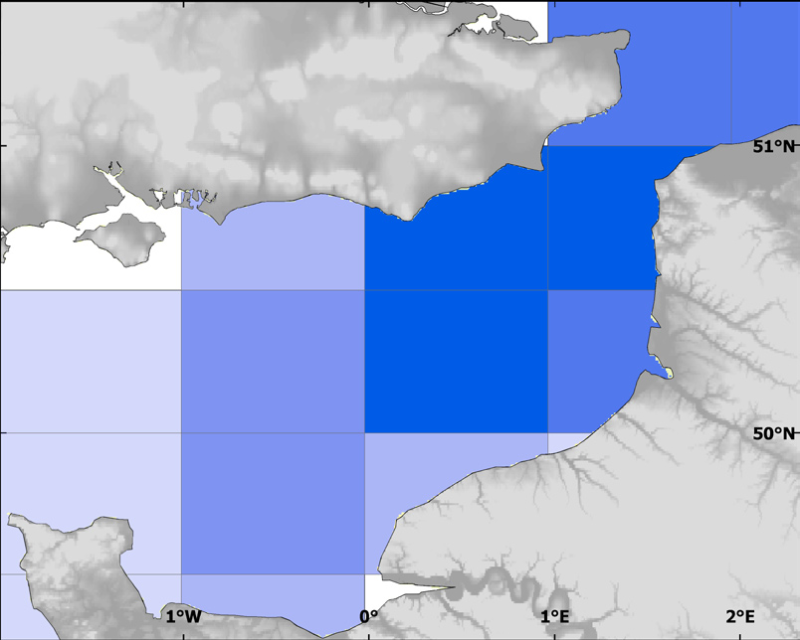
Fishing activities - Merlangius merlangus (Whiting) - Landings statistics (2000-2004)
Landings in tonnes of live fish per quarter: mean over 5 years (2000-2004), International (FR,UK,Belgique, Pays-Bas, Danemark, Allemagne)
Simple
- Title
-
Fishing activities - Merlangius merlangus (Whiting) - Landings statistics (2000-2004)
- Alternate title
-
landings_species_statistics
- Date (Publication)
- 2009-12-31T00:00:00
- Citation identifier
- CHARM_LAND_STAT_MERNMER1_P
- Presentation form
- Digital map
- Other citation details
-
Source CHARM Consortium
- Abstract
-
Landings in tonnes of live fish per quarter: mean over 5 years (2000-2004), International (FR,UK,Belgique, Pays-Bas, Danemark, Allemagne)
- Credit
-
Ifremer
- Credit
-
CHARM Consortium
- Status
- Completed
- Point of contact
-
Organisation name Individual name Electronic mail address Role CHARM Consortium
CHARM Consortium
Production center Ifremer
Frank Coppin
Product manager
- Maintenance and update frequency
- As needed
-
Thèmes Sextant
-
-
/Human Activities/Recreational Fishing
-
- Theme
-
-
Exploitation
-
CHARM
-
-
GEMET - INSPIRE themes, version 1.0
-
-
Répartition des espèces
-
-
external.theme.gemet
-
-
pêche maritime
-
- Use limitation
-
research-only
- Access constraints
- License
- Other legal constraints
-
Has to be cited this way in maps : "Source CHARM Consortium"
- Other legal constraints
-
Has to be cited this way in bibliography : "Carpentier A, Martin CS, Vaz S (Eds.), 2009. Channel Habitat Atlas for marine Resource Management, final report / Atlas des habitats des ressources marines de la Manche orientale, rapport final (CHARM phase II). INTERREG 3a Programme, IFREMER, Boulogne-sur-mer, France. 626 pp. & CD-rom"
- Spatial representation type
- Vector
- Denominator
- 10000
- Language
- Français
- Language
- English
- Character set
- UTF8
- Topic category
-
- Imagery base maps earth cover
- Biota
- Environment
- Economy
- Environment description
-
Microsoft Windows XP ; ESRI ArcGIS 9.x
- Geographic identifier
- Eastern English Channel
))
- Begin date
- 2000-01-01
- End date
- 2006-01-31
- Reference system identifier
- 4326
- Topology level
- Geometry only
- Geometric object type
- Surface
- Geometric object count
- 35
Distributor
- Distributor contact
-
Organisation name Individual name Electronic mail address Role Ifremer - Centre de Brest
Dissemination Unit
- Distributor format
-
Name Version
- OnLine resource
-
Protocol Linkage Name WWW:LINK
http://www.ifremer.fr/charm/ OGC:WMS
https://sextant.ifremer.fr/services/wms/wms_charm? CHARM_LAND_STAT_MERNMER1_P
OGC:WMS
https://sextant.ifremer.fr/services/wms/wms_charm? CHARM_LAND_STAT_MERNMER2_P
OGC:WMS
https://sextant.ifremer.fr/services/wms/wms_charm? CHARM_LAND_STAT_MERNMER3_P
OGC:WMS
https://sextant.ifremer.fr/services/wms/wms_charm? CHARM_LAND_STAT_MERNMER4_P
FILE
CHARM_LAND_STAT_ALL_P
- Hierarchy level
- Dataset
- Statement
-
Data extracted from the French and UK databases were used to produce maps showing the distribution of landings by quarter and statistical division, for about 30 species (in tonnes of fresh fish).
- Description
-
Landings (in tonnes of fresh fish) are averaged over 5 or 7 years per quarter per species. Note : British landings did not separate Raja clavata to Raja montagui (so called Rajidae in the atlas)
- Description
-
Landings and fishing effort collected in logbooks, centralised since 2006 in France by a national centre for statistical analyses (CNTS) and transfered in 2009 to France Agrimer and by the Department for Environment, Food and Rural Affairs (DEFRA) for UK
Metadata
- File identifier
- 91a5b920-02dd-11e0-abec-005056987263
- Metadata language
- English
- Character set
- UTF8
- Hierarchy level
- Dataset
- Date stamp
- 2020-06-04T01:03:56
- Metadata standard name
-
ISO 19115:2003/19139 - SEXTANT
- Metadata standard version
-
1.0
- Metadata author
-
Organisation name Individual name Electronic mail address Role Ifremer
Sandrine Vaz
Local service desk
accessData
Overviews
)))