EUMETSAT OSI SAF Full resolution Metop-A Sea Surface Temperature metagranules
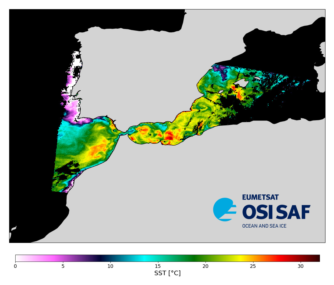
Level 2 sub-skin Sea Surface Temperature derived from AVHRR on Metop, global and provided in full-resolution swath (1 km at nadir), in GHRSST compliant netCDF format.
The satellite input data has successively come from Metop-A, Metop-B and Metop-C level 1 data processed at EUMETSAT. SST is retrieved from AVHRR infrared channels (3.7, 10.8 and 12.0 µm) using a multispectral algorithm and a cloud mask. Atmospheric profiles of water vapor and temperature from a numerical weather prediction model, Sea Surface Temperature from an analysis, together with a radiative transfer model, are used to correct the multispectral algorithm for regional and seasonal biases due to changing atmospheric conditions.
The quality of the products is monitored regularly by daily comparison of the satellite estimates against buoy measurements.The product format is compliant with the GHRSST Data Specification (GDS) version 2. Users are advised to use data only with quality levels 3,4 and 5.
Simple
Identification info
- Date (Creation)
- 2007-11-26
- Date (Publication)
- 2007-11-26
- Citation identifier
- AVHRR_SST_METOP_A-OSISAF-L2P-v1.0
- Status
- Completed
- Point of contact
-
Organisation Individual Electronic mail address ORCID Role Météo-France
Stéphane Saux Picart
Author OSI SAF Help Desk
Point of contact Ifremer/CERSAT > Centre de Recherche et d'Exploitation Satellitaire, Institut Français de Recherche et d'Exploitation de la Mer
Distributor EUMETSAT
Distributor NASA/JPL/PODAAC > Physical Oceanography Distributed Active Archive Center, Jet Propulsion Laboratory, NASA
Distributor Météo-France
Originator EUMETSAT
Funder Météo-France
Funder
- Spatial representation type
- Grid
Spatial resolution
- Spatial resolution
- 1 km
- Temporal resolution
-
P0Y0M0DT0H3M0S
- Topic category
-
- Oceans
Extent
))
- Geographic identifier
- Global
Extent
- Time period
- 2007-11-26 2016-11-23
- Data centre
-
-
CERSAT
-
- Product
-
-
Remote sensing
-
- GEMET - INSPIRE themes, version 1.0
-
-
Oceanographic geographical features
-
- Cersat - Parameter
-
-
Ocean Temperature
-
- Cersat - Project
-
-
GHRSST
-
OSI SAF
-
- Cersat - Latency
-
-
Less than 6 hours
-
- Cersat - GCMD parameter
-
-
/Ocean Temperature
-
/Ocean Temperature/Sea Surface Temperature
-
- Thèmes Sextant
-
-
/Imagery/Satellite Imagery
-
- Cersat - Processing level
-
-
L1
-
- Centre de données ODATIS
-
-
CDS-CERSAT
-
- Type de jeux de donnée ODATIS
-
-
/Observational data/satellite
-
Resource specific usage
- Specific usage
-
Issue
Identified issues
- Date (Validity Begins)
- Date (Validity Expires)
Resource specific usage
- Specific usage
-
Update
Resource constraints
- Use limitation
-
None
- Access constraints
- Unrestricted
- Use constraints
- Other restrictions
- Other constraints
- Open Licence
- Other constraints
-
EUMETSAT Ocean and Sea Ice Satellite Application Facility, Full resolution Sea Surface Temperature metagranules (Metop-A) 2007-2016, doi:10.15770/EUM_SAF_OSI_NRT_2013, data for [extracted period], [extracted domain], accessed [download date] from [distributor/distribution mean].
Associated resource
- Title
-
Piolle et al. 2019
- Association Type
Content Information
- Attribute description
- 3-min granule
- Processing level code
- L2P
Distribution Information
- Distribution format
-
-
NetCDF
-
- OnLine resource
-
Ifremer FTP server
FTP (credentials to be requested: at http://www.osi-saf.eumetsat.int)
- OnLine resource
-
Local path on Ifremer/Datarmor
Local path on Datarmor (Ifremer restricted) platform
- OnLine resource
-
Ifremer HTTP server
HTTPS
- OnLine resource
-
PO.DAAC Cloud
HTTPS
- OnLine resource
-
User guide
Product User Guide
- OnLine resource
-
OSI SAF Opensearch service
- OnLine resource
-
EUMETView
View service WMS
- OnLine resource
-
EUMETCast
- OnLine resource
-
Digital Object Identifier (DOI)
Resource lineage
- Lineage
-
Global AVHRR level 1b data are acquired at Meteo-France/Centre de Meteorologie Spatiale (CMS) through the EUMETSAT/EUMETCAST system. SST is retrieved from the AVHRR infrared channels (3.7, 10.8 and 12.0 micrometer) using a multispectral algorithm. Atmospheric profiles of water vapor and temperature from a numerical weather prediction model, together with a radiatiave transfer model, are used to correct the multispectral algorithm for regional and seasonal biases due to changing atmospheric conditions.
Process step
- Identifier
- v1.0
- Hierarchy level
- Dataset
Reference System Information
- Reference system identifier
- http://www.opengis.net/def/crs/EPSG/0/4326
- Reference system type
- Hierarchy level
- Instrument
-
Instrument Platform AVHRR/3
METOP-A
Metadata
- Metadata identifier
- urn:uuid/9453982d-9d34-40d6-b13a-aea681c9f6fb
- Language
- English
- Character encoding
- UTF8
- Contact
-
Organisation Individual Electronic mail address ORCID Role CERSAT Exploitation
Editor
Type of resource
- Resource type
- Series
- Metadata linkage
-
https://sextant.ifremer.fr/geonetwork/srv/eng//metadata/bdb4a75c-7c4c-4907-bc5b-341ba3eb9481
- Date info (Revision)
- 2024-10-15T14:57:49.371207Z
- Date info (Creation)
- 2023-06-22T04:12:15.315Z
Metadata standard
- Title
-
ISO 19115-3:2018 - Remote Sensing
accessData
Overviews
Spatial extent
)))