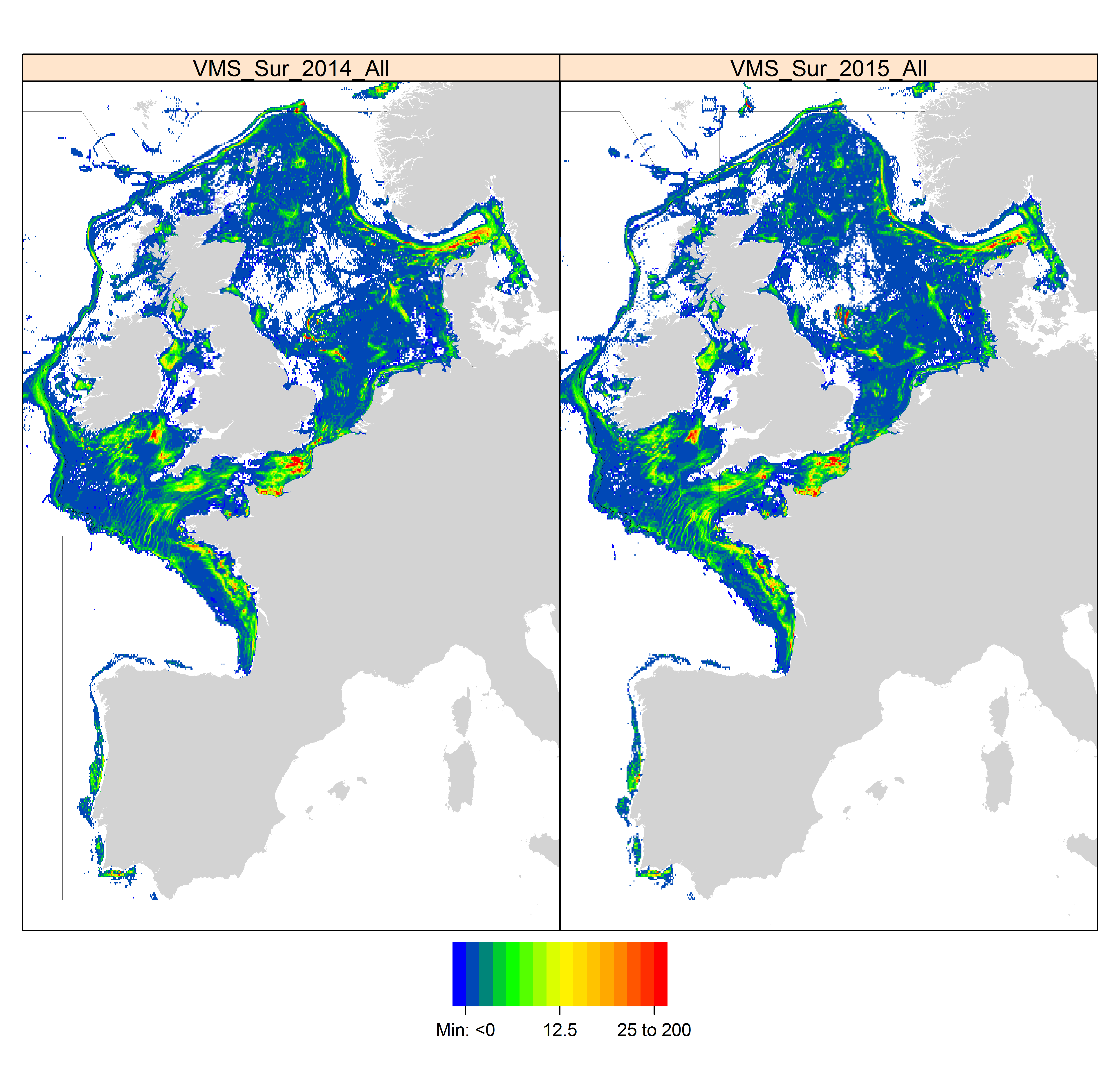
Fishing effort | High Resolution VMS & ERS (Logbook) Fishing Intensity Data | | OSPAR mapping fishing intensity and effort outputs 2016
Simple
Identification info
- Alternate title
-
OSPAR mapping fishing intensity and effort outputs 2016
- Date
- Citation identifier
- Fishing effort | High Resolution VMS & ERS (Logbook) Fishing Intensity Data | | OSPAR mapping fishing intensity and effort outputs 2016
- Convention
-
OSPAR mapping fishing intensity and effort outputs 2016
- Purpose
-
To illustrate the spatial and temporal coverage of OSPAR bottom fishing intensity in the NE Atlantic region
- Status
- On going
- Point of contact
-
Organisation Individual Electronic mail address ORCID Role Working Group on Spatial Fisheries Data
WGSFD
edmerp
- Spatial representation type
- Vector
Spatial resolution
- Spatial resolution
- 3000 meter
- Topic category
-
- Oceans
Extent
))
Extent
- Time period
- 2014 2015
- Maintenance and update frequency
- Unknown
- Used by challenges
-
-
Atlantic - CH07 - Fisheries Impact
-
- Environmental matrix
-
-
Human activities
-
- Production mode
-
-
Delayed
-
- Visibility
-
-
Use of open search engines, searching by name either the data provider or the characteristics
-
- Policy visibility
-
-
There is detailed information provided to understand data policy
-
- Readyness
-
-
Format proprietary but content clearly specified
-
- Parameter Discovery Vocabulary (P02)
-
-
Fishing effort
-
- GEMET - INSPIRE themes, version 1.0
-
-
Sea regions
-
- Processing level of characteristics
-
-
High level analyzed
-
- Data delivery mechanisms
-
-
Online discovery and downloading services
-
- Parameter Usage Vocabulary (other)
-
-
High Resolution VMS & ERS (Logbook) Fishing Intensity Data
-
- Agreed Parameter Groups (P03)
-
-
Human activity
-
- Service extent
-
-
The datasets are referenced in a public national catalogue, in an international catalogue service
-
- Validation
-
-
Draft
-
Resource constraints
- Access constraints
- Other restrictions
- Other constraints
-
Unrestricted
- Language
- Français
- Character encoding
- UTF8
- Environment description
-
The impact of fishing on benthic habitats has previously been investigated however; a conclusive classification of potentially sensitive habitats per gear type does not exist. Currently only qualitative estimates of fishery impact using broad-scale habitat maps are possible. Here a sensitivity matrix using both fishing pressure and habitat sensitivity is employed to define pressure categories. A matrix-approach used to combine sensitivity and pressure is used to predict disturbance
Content Information
- Attribute description
- observation
- Content type
- Physical measurement
Distribution Information
- Distribution format
-
-
ESRI Shapefile
-
ZIP
-
- OnLine resource
-
Publication Reports Data outputs
ATLANTIC_CH07_Product_2 / Damage to seafloor to both living and non-living components
))
- Begin date
- 2006
- End date
- 2015
Vertical element
- Minimum value
- 0
- Maximum value
- 1000
Resource lineage
- Hierarchy level
- Dataset
Spatial representation info
- Dimension name
- Time
- Resolution
- 2 year
- Cell geometry
- Transformation parameter availability
- true
- Check point availability
- true
Metadata
- Metadata identifier
- urn:uuid/955f13bf-0cda-463a-a865-9d92bd22c2aa
- Language
- English
- Character encoding
- UTF8
- Contact
-
Organisation Individual Electronic mail address ORCID Role Marine Institute
Type of resource
- Resource type
- Dataset
- Name
-
Atlantic - CH07 - Fisheries Impact
- Metadata linkage
-
https://sextant.ifremer.fr/geonetwork/srv/eng//metadata/955f13bf-0cda-463a-a865-9d92bd22c2aa
- Date info (Revision)
- 2018-04-10T14:45:33Z
- Date info (Creation)
- 2014-10-08T14:35:32
Metadata standard
- Title
-
ISO 19115-3 - Emodnet Checkpoint - Upstream Data
- Edition
-
1.0
OSPAR mapping fishing intensity and effort outputs 2016
accessData
Overviews
Spatial extent
)))