Formations superficielles sous-marines entre Port-Barcarès et Saint-Cyprien (scan géoréférencé)
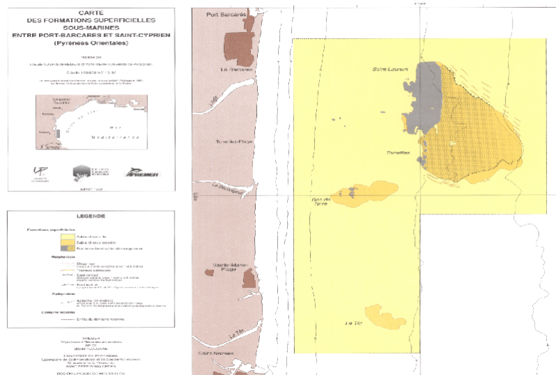
Scan de la "Carte des formations superficielles sous-marines entre Port-Barcarès et Saint-Cyprien" (édition 1993, échelle 1/20 000).
Campagne océanographique à l'origine de cette carte : AUGRIS Claude (1984) RECIFS ARTIFICIELS cruise, RV Ichtys, https://doi.org/10.17600/84004411
Simple
- Title
-
Formations superficielles sous-marines entre Port-Barcarès et Saint-Cyprien (scan géoréférencé)
- Alternate title
-
IFR_SED_ROUSSILLON_1993_R
- Alternate title
-
roussillon_georef = IFR_SED_ROUSSILLON -> IFR_SED_ROUSSILLON_1993_R
- Date (Creation)
- 1993-01-01T00:00:00
- Date (Publication)
- 2006-08-01T00:00:00
- Edition
-
carte papier, édition Ifremer - Région Languedoc Roussillon
- Edition date
- 1993-01-01T00:00:00
- Citation identifier
- FR-330-715-368-00032-FormationsSup_Roussillon_Augris_1993_ScanGeoref
- Presentation form
- Digital map
- Abstract
-
Scan de la "Carte des formations superficielles sous-marines entre Port-Barcarès et Saint-Cyprien" (édition 1993, échelle 1/20 000).
Campagne océanographique à l'origine de cette carte : AUGRIS Claude (1984) RECIFS ARTIFICIELS cruise, RV Ichtys, https://doi.org/10.17600/84004411
- Credit
-
Ifremer / Université de Perpignan / Région Languedoc-Roussillon
- Status
- Completed
- Point of contact
-
Organisation name Individual name Electronic mail address Role Ifremer
Geo-Ocean
Local service desk Ifremer
AUGRIS Claude
Author Université de Perpignan
MEAR Yann
Author
- Maintenance and update frequency
- Not planned
-
Thèmes Sextant
-
-
/Cartes scannées/Ifremer/Sédimentologie
-
-
GEMET - INSPIRE themes, version 1.0
-
-
Géologie
-
-
external.theme.gemet
-
-
sédiment marin
-
fond marin
-
- Theme
-
-
formations superficielles
-
natures des fonds
-
- Place
-
-
Port-Barcarès
-
Saint-Cyprien
-
Languedoc-Roussillon
-
Méditerranée France
-
Golfe du Lion
-
- Discipline
-
-
sédimentologie
-
géophysique
-
- Use limitation
- CC-BY (Creative Commons - Attribution)
- Access constraints
- Other restrictions
- Use constraints
- License
- Other legal constraints
-
Pas de restriction d'accès public
- Other legal constraints
-
Proposition de citation : AUGRIS C., MEAR Y. (1993) - Carte des formations superficielles sous-marines entre Port Barcarès et Saint-Cyprien (Pyrénées Orientales). Echelle 1/20 000. Ed. Ifremer - Région Languedoc Roussillon.
- Spatial representation type
- Grid
- Denominator
- 20000
- Language
- Français
- Character set
- UTF8
- Topic category
-
- Geoscientific information
- Description
-
Période d'acquisition des données
- Begin date
- 1984-10-20T09:29:00
- End date
- 1984-10-30T09:29:00
))
- Reference system identifier
- ED50 / Mercator parallèle de référence 43°15' / SR-ORG:6859
- Number of dimensions
- 2
- Dimension name
- Column
- Dimension size
- 3722
- Resolution
- 3.439719 mètre
- Dimension name
- Row
- Dimension size
- 7294
- Resolution
- 3.399982 mètre
- Cell geometry
- Area
- Transformation parameter availability
- Distribution format
-
Name Version GeoTIFF
1.0
- Distributor contact
-
Organisation name Individual name Electronic mail address Role Ifremer - Centre de Brest
Dissemination Unit
- OnLine resource
-
Protocol Linkage Name OGC:WMS
https://sextant.ifremer.fr/services/wms/gm_geologie FormationsSup_Roussillon_Augris_1993_ScanGeoref
COPYFILE
FormationsSup_Roussillon_Augris_1993_ScanGeoref
- OnLine resource
-
Protocol Linkage Name WWW:LINK
http://dx.doi.org/10.17600/84004411 Campagne RECIFS ARTIFICIELS
- Hierarchy level
- Dataset
Conformance result
- Title
-
INSPIRE
- Date (Publication)
- 2007-03-14
- Explanation
-
Non évalué
- Pass
- Statement
-
Carte originale papier
- Description
-
Carte originale papier scannée
Metadata
- File identifier
- 9a665590-f097-11df-abec-005056987263
- Metadata language
- Français
- Character set
- UTF8
- Hierarchy level
- Dataset
- Date stamp
- 2023-05-23T08:52:36.731Z
- Metadata standard name
-
ISO 19115:2003/19139 - SEXTANT
- Metadata standard version
-
1.0
- Metadata author
-
Organisation name Individual name Electronic mail address Role Ifremer
Geo-Ocean
Local service desk
accessData
Overviews
)))