SEdimentology and Aquitaine Image Mosaic Dynamics - SEDYMAQ
Monitoring the evolution of the Aquitain platform off the coast of the Médoc region (at depths of between 70 and 120 m) and the internal pladeau at la Salie and Truc vert (at depths of between 10 and 40 m) as well as at the head of the Capbreton Canyon (at depths of between 10 and 300m).
Simple
- Title
-
SEdimentology and Aquitaine Image Mosaic Dynamics - SEDYMAQ
- Date (Creation)
- 2008-01-01T00:00:00
- Citation identifier
- FR-DCSMM-PDS-SEDYMAQ
- Presentation form
- Digital profile
- Abstract
-
Monitoring the evolution of the Aquitain platform off the coast of the Médoc region (at depths of between 70 and 120 m) and the internal pladeau at la Salie and Truc vert (at depths of between 10 and 40 m) as well as at the head of the Capbreton Canyon (at depths of between 10 and 300m).
- Purpose
-
The aim of the SEDYMAQ programme is to gather new geophysical and sedimentology data around work areas of the Aquitaine plateau on which measurements were regularly taken in the 80s and 90s. Through a comparative analysis of the data from different periods, the main objective of the SEDYMAQ programme is to evaluate the long-term evolution of sediment data and to establish a sediment report for works areas over the given periods.
- Credit
-
Data producers : EPOC (Université Bordeaux 1)
- Status
- On going
- Point of contact
-
Organisation name Individual name Electronic mail address Role Université Bordeaux 1
Gillet Hervé
Local service desk
- Maintenance and update frequency
- Unknown
- Maintenance note
-
Network Time : temporary network
- Theme
-
-
Sedimentology
-
Bathymetry
-
Comparative analysis
-
Aquitaine plateau
-
Sediment mapping
-
morpho-sedimentary study
-
-
GEMET - INSPIRE themes, version 1.0
-
-
Environmental monitoring facilities
-
-
Sous-regions marines
-
-
Bay of Biscay
-
-
DCSMM : Type d'espace concerné
-
-
Pas d'espace particulier concerné
-
-
DCSMM : Descripteurs
-
-
D7: Hydrographical Conditions
-
-
DCSMM : Méthodes de recueil des données
-
-
Observation par point
-
Observation par transect
-
Interprétation de cartographies
-
-
Thèmes Sextant
-
-
/Physical Environment/Geology/Seabed Nature
-
- Access constraints
- Other restrictions
- Other legal constraints
-
Restricted access
- Spatial representation type
- Vector
- Denominator
- 50000
- Language
- Français
- Character set
- UTF8
- Topic category
-
- Oceans
))
- Supplemental Information
-
Project leader :
Université Bordeaux 1 2008
Prime contractor :
Université Bordeaux 1 2008
Backer :
Programme INSU Relief de la terre
INSU Action Marges 2008
- Reference system identifier
- EPSG / WGS 84 (EPSG:4326) / 7.9
- Topology level
- Geometry only
- Geometric object type
- Complex
- Geometric object count
- 0
- Hierarchy level
- Dataset
Conformance result
- Title
-
Inspire specifications
- Date (Creation)
- 2012-01-16
- Explanation
-
Non assessed
- Pass
- Statement
-
August 2008 : SEDYMAQ 1 Mission August 2009 : GOUFHEAD Mission
June 2010 : SEDYMAQ 2 Mission
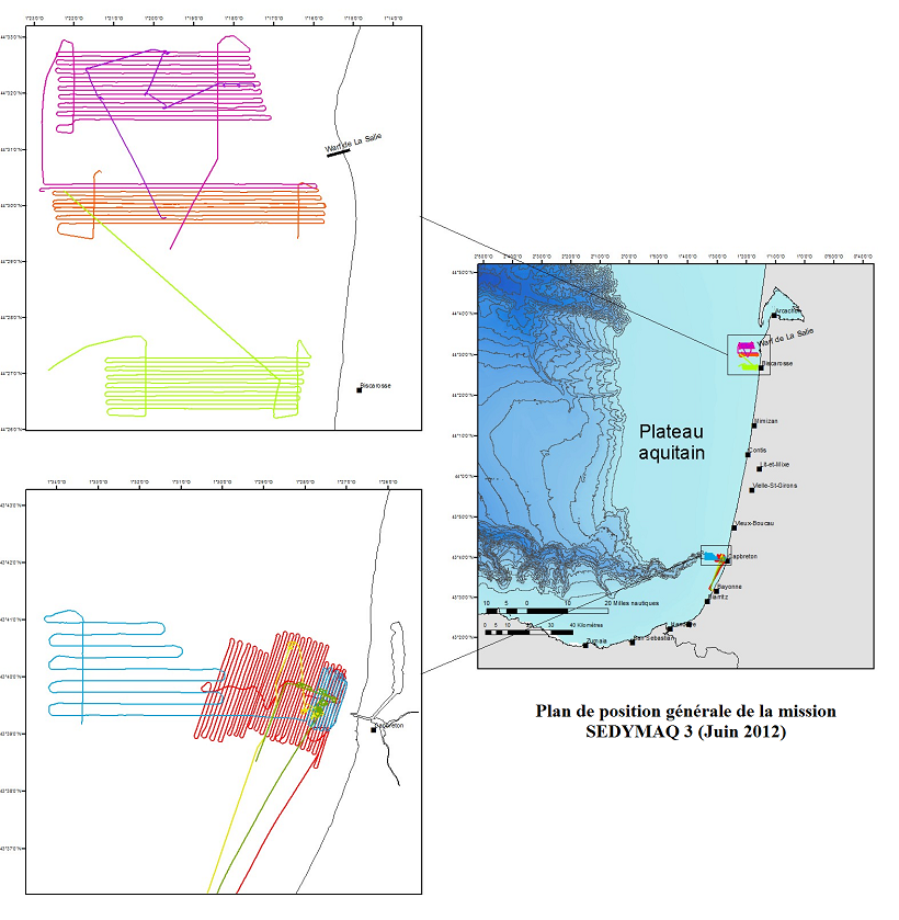
June 2012 : SEDYMAQ 3 Mission
Number of observation or measurement points :
Total for both campaigns : 164 samples at the Shipeck grab, 1633 km of multi-beam data, 1292 km of side-scan sonar, and creation of 8 image mosaics using the sounder and 6 sonar mosaics.
Collection Methods : multibeam echosounders, sediment profiler, side-scan sonar, sediment sampling http://www.epoc.u-bordeaux.fr/index.php? lang=fr&page=actus3_infos&id=78
http://www.epoc.u-bordeaux.fr/index.php? lang=fr&page=actus3_infos&id=117
- Description
-
Data type :
Physical oceanography
Hydrography
Geology
Precision on the data type :
Bathymetry
Sedimentology
Measured or observed parameters :
depth
Granulometry (samples)
Imagery (side-scan sonar)
Geometry of sediment bodies (sediment profiler)
Parameters resolution : Variable (from 5 m to 0.5 m)
- Description
-
Sampling method : Spatial
Metadata
- File identifier
- 9c2a775f-8e7f-46df-90b6-0d34c917f18e
- Metadata language
- Français
- Other language
-
Language Character encoding English
- Character set
- UTF8
- Hierarchy level
- Series
- Date stamp
- 2024-04-05T08:09:21.764Z
- Metadata standard name
-
ISO 19115:2003/19139 - SEXTANT
- Metadata standard version
-
1.0
- Metadata author
-
Organisation name Individual name Electronic mail address Role Sextant
Local service desk
accessData
Overviews
)))