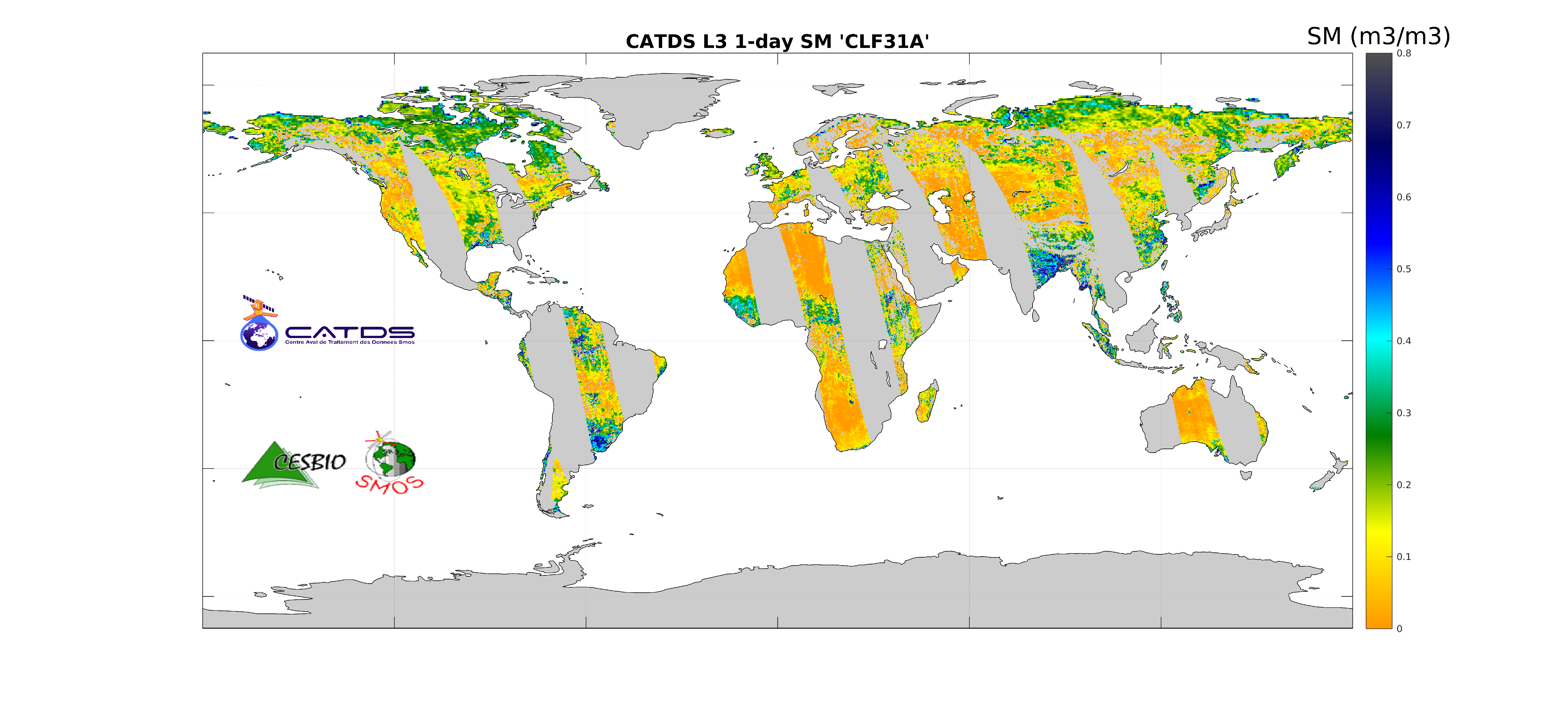
CATDS-PDC L3SM Filtered - 1 day global map of soil moisture values from SMOS satellite
This product is the daily product of soil moisture, and contains filtered data. The retrievals are based on a multi-orbit retrieval algorithm. A detection of freeze and snow is performed and added to the flags. Ascending and descending orbits are processed separately.
Simple
- Title
-
CATDS-PDC L3SM Filtered - 1 day global map of soil moisture values from SMOS satellite
- Date (Publication)
- 2022-02-14
- Citation identifier
- CATDS-PDC_L3SM_Filtered
- Citation identifier
- DOI:10.12770/9cef422f-ed3f-4090-9556-b2e895ba2ca8
- Abstract
-
This product is the daily product of soil moisture, and contains filtered data. The retrievals are based on a multi-orbit retrieval algorithm. A detection of freeze and snow is performed and added to the flags. Ascending and descending orbits are processed separately.
- Credit
-
CATDS (CNES, IFREMER, CESBIO)
- Point of contact
-
Organisation name Individual name Electronic mail address Role CATDS
Author CESBIO
Arnaud Mialon
Principal investigator CATDS (CNES, IFREMER, CESBIO)
Publisher
-
Thèmes Sextant
-
-
/Imagery/Satellite Imagery
-
-
GEMET - INSPIRE themes, version 1.0
-
-
Orthoimagery
-
- Theme
-
-
SMOS
-
CATDS
-
CPDC
-
L3SM
-
Soil Moisture
-
Filtered
-
Land Product
-
- Use limitation
-
Creative Commons license to apply : Attribution (BY) : http://creativecommons.org/licenses/?lang=en
- Access constraints
- License
- Use constraints
- License
- Spatial representation type
- Grid
- Denominator
- 1
- Language
- English
- Character set
- UTF8
- Topic category
-
- Geoscientific information
))
- Begin date
- 2010-01-12
- Reference system identifier
- EPSG / WGS 84 / NSIDC EASE-Grid 2.0 Global (EPSG:6933) / 8.6
- Number of dimensions
- 3
- Dimension name
- Column
- Dimension size
- 1388
- Dimension name
- Vertical
- Dimension size
- 584
- Dimension name
- Sample
- Dimension size
- 14
- Cell geometry
- Area
- Transformation parameter availability
- Distribution format
-
Name Version NetCDF
netcdf 3 with 64 bit offset option
- OnLine resource
-
Protocol Linkage Name WWW:DOWNLOAD-1.0-link--download
https://data.catds.fr/cpdc/Land_products/GRIDDED/L3SM/RE07/MIR_CLF31A RE07-ASC
WWW:DOWNLOAD-1.0-link--download
https://data.catds.fr/cpdc/Land_products/GRIDDED/L3SM/RE07/MIR_CLF31D RE07-DESC
WWW:DOWNLOAD-1.0-link--download
https://data.catds.fr/cpdc/Land_products/GRIDDED/L3SM/OPER/MIR_CLF31A OPER-ASC
WWW:DOWNLOAD-1.0-link--download
https://data.catds.fr/cpdc/Land_products/GRIDDED/L3SM/OPER/MIR_CLF31D OPER-DESC
WWW:LINK-1.0-http--metadata-URL
http://dx.doi.org/10.12770/9cef422f-ed3f-4090-9556-b2e895ba2ca8 DOI of the dataset
WWW:DOWNLOAD-1.0-link--download
ftp://ftp.ifremer.fr/ FTP Access
- OnLine resource
-
Protocol Linkage Name WWW:LINK
https://www.catds.fr/sipad/ CATDS Sipad
WWW:LINK
https://www.catds.fr/ CATDS Web portal
- OnLine resource
-
Protocol Linkage Name WWW:LINK-1.0-http--publication-URL
http://doi.org/10.5194/essd-9-293-2017 Reference
- Hierarchy level
- Dataset
- Statement
-
The base products, for all the CATDS-PDC (Centre Aval de Traitement des Données SMOS - Production & Dissemination Center) processing chains, are the SMOS L1B products - https://doi.org/10.57780/SM1-e20cf57 - from ESA (European Space Agency).
The L3SM filtered product is the daily product of soil moisture, and contains filtered data. The retrievals are based on a multi-orbit retrieval algorithm. A detection of freeze and snow is performed and added to the flags. Ascending and descending orbits are processed separately. The aggregated products are generated from this fundamental product.
Products from reprocessing RE07 are available for the period 01/2010 - 05/2021. Products from operational (OPER) processing are available since 06/2021. Reprocessed products and operational products are derived using the same algorithm and configuration, hence ensuring the temporal continuity.
File naming :
SM_clas_MIR_CLF31x_startdate_enddate_vvv_ccc_7
- clas : File class (OPER : operational mode, REXX : reprocessing xx)
- x : A for ascending orbit, D for descending orbit
- startdate : sensing start date/time of the data (format yyyymmddThhmiss)
- enddate : sensing end date/time of the data (format yyyymmddThhmiss)
- vvv : version number of the processor generating the product
- ccc : file counter
File format :
In each archive file (.tgz extension), there are two files
- A Header file (.HDR), which is a text file, in XML Earth Explorer Header format
- A Data file (.DBL.nc), which is a netcdf file, format variant 2 (netcdf 3 with 64 bits offset option)
Reference :
Al Bitar Ahmad, Mialon Arnaud, Kerr Yann H., Cabot Francois, Richaume Philippe, Jacquette Elsa, Quesney Arnaud, Mahmoodi Ali, Tarot Stephane, Parrens Marie, Al-Yaari Amen, Pellarin Thierry, Rodriguez-Fernandez Nemesio, Wigneron Jean-Pierre (2017). The global SMOS Level 3 daily soil moisture and brightness temperature maps. Earth System Science Data, 9(1), 293-315. Publisher's official version : http://doi.org/10.5194/essd-9-293-2017 , Open Access version : http://archimer.ifremer.fr/doc/00388/49941/
Metadata
- File identifier
- 9cef422f-ed3f-4090-9556-b2e895ba2ca8
- Metadata language
- English
- Character set
- UTF8
- Hierarchy level
- Dataset
- Date stamp
- 2023-12-21T07:40:28.162Z
- Metadata standard name
-
ISO 19115:2003/19139 - SEXTANT
- Metadata standard version
-
1.0
- Metadata author
-
Organisation name Individual name Electronic mail address Role IFREMER
Tarot Stephane
Local service desk
accessData
Overviews
)))