Conservation status of habitat types and species: datasets from Article 17, Habitats Directive 92/43/EEC reporting (2013-2018) - PUBLIC VERSION - Aug. 2020
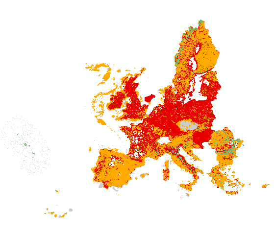
All Member States are requested by the Habitats Directive (92/43/EEC) to monitor habitat types and species listed in its annexes and send a report every 6 years following an agreed format. The assessment of conservation status is based on information about the status and trends of species populations and of habitats at the level of the biogeographical or marine region. The spatial dataset contains habitat and species distribution data (10km grid cells) as reported by Member States for the 2013-2018 period. This metadata refers to the public dataset, without sensitive species.
The data sets are divided in two sets for species and two sets for habitat types.
Species:
ART17 species distribution MS (by Member State)
ART17 species distribution EU (European Union aggregate)
Habitats:
ART17 habitats distribution MS (by Member State)
ART17 habitats distribution EU (European Union aggregate)
Both MS datasets are aggregated by habitat/species code, country and biogeographical /marine region [CO_MS_RE]. Using this attribute [CO_MS_RE] the tabular conservation status, which is available in the table, per biogeographical/marine region of the Member State level (MS) can be joined directly to the spatial dataset.
Both EU datasets are aggregated by habitat/species code and biogeographical /marine region [CO_RE]. Using this attribute [CO_RE] the tabular conservation status, which is available in the table, of the biogeographical/marine region of the EU-28 level (EU) can be directly joined to the spatial dataset.
Further description of the Article 17 tabular and spatial dataset and a Article 17 web tool can be accessed with the download data.
Simple
- Title
-
Conservation status of habitat types and species: datasets from Article 17, Habitats Directive 92/43/EEC reporting (2013-2018) - PUBLIC VERSION - Aug. 2020
- Date (Creation)
- 2020-08-27
- Date (Publication)
- 2020-08-27
- Date (nextUpdate)
- 2026-01-01
- Edition
-
01.00
- Citation identifier
- eea_v_3035_10_mio_art17-2013-2018_p_2013-2018_v01_r00
- Citation identifier
- DAT-15-en
- Abstract
-
All Member States are requested by the Habitats Directive (92/43/EEC) to monitor habitat types and species listed in its annexes and send a report every 6 years following an agreed format. The assessment of conservation status is based on information about the status and trends of species populations and of habitats at the level of the biogeographical or marine region. The spatial dataset contains habitat and species distribution data (10km grid cells) as reported by Member States for the 2013-2018 period. This metadata refers to the public dataset, without sensitive species.
The data sets are divided in two sets for species and two sets for habitat types.
Species:
ART17 species distribution MS (by Member State)
ART17 species distribution EU (European Union aggregate)
Habitats:
ART17 habitats distribution MS (by Member State)
ART17 habitats distribution EU (European Union aggregate)
Both MS datasets are aggregated by habitat/species code, country and biogeographical /marine region [CO_MS_RE]. Using this attribute [CO_MS_RE] the tabular conservation status, which is available in the table, per biogeographical/marine region of the Member State level (MS) can be joined directly to the spatial dataset.
Both EU datasets are aggregated by habitat/species code and biogeographical /marine region [CO_RE]. Using this attribute [CO_RE] the tabular conservation status, which is available in the table, of the biogeographical/marine region of the EU-28 level (EU) can be directly joined to the spatial dataset.
Further description of the Article 17 tabular and spatial dataset and a Article 17 web tool can be accessed with the download data.
Point of contact
- Maintenance and update frequency
- Continual
-
EEA topics
-
-
Biodiversity
-
Water
-
-
Continents, countries, sea regions of the world.
-
-
North Sea
-
Mediterranean Sea
-
Northeast Atlantic Ocean (40W)
-
Black Sea
-
Baltic Sea
-
EU28 (2013-2020)
-
- Keywords
-
-
GEMET
-
-
biodiversity
-
biodiversity conservation
-
nature conservation policy
-
conservation
-
habitat
-
habitats directive
-
nature conservation
-
natural area
-
ecosystem
-
species
-
- Keywords
-
-
INSPIRE priority data set
-
-
Directive 92/43/EEC
-
Species distribution (Habitats Directive)
-
Habitat types distribution (Habitats Directive)
-
-
EEA Management Plan
-
-
2020 1.7.2
-
-
Sous-regions marines
-
-
/Métropole
-
/Métropole/Manche mer du Nord
-
/Métropole/Mers Celtiques
-
/Métropole/Golfe de Gascogne
-
/Métropole/Méditerranée occidentale
-
-
Thématiques - SIMM
-
-
/Etat du Milieu/Espèces
-
-
Thématiques - SIMM
-
-
/Etat du Milieu/Habitats
-
-
Type de jeux de donnée - ODATIS
-
-
/Données dérivées/Produits composites
-
-
Cadre Réglementaire - SIMM
-
-
Directive Habitat, Faune et Flore
-
- Access constraints
- Other restrictions
- Other legal constraints
- no limitations to public access
- Use constraints
- Other restrictions
- Other legal constraints
-
EEA standard re-use policy: unless otherwise indicated, re-use of content on the EEA website for commercial or non-commercial purposes is permitted free of charge, provided that the source is acknowledged (http://www.eea.europa.eu/legal/copyright). Copyright holder: Directorate-General for Environment (DG ENV), European Environment Agency (EEA).
- Aggregate Datasetindentifier
- c6d27566-e699-4d58-a132-bbe3fe01491b
- Association Type
- Cross reference
- Spatial representation type
- Vector
- Denominator
- 10000000
- Language
- English
- Character set
- UTF8
- Topic category
-
- Environment
- Biota
- Begin date
- 2013-01-01
- End date
- 2018-12-31
))
- Unique resource identifier
- EPSG:3035
- Distribution format
-
Name Version GDB
Geopackage
- OnLine resource
-
Protocol Linkage Name EEA:FOLDERPATH
https://sdi.eea.europa.eu/webdav/datastore/public/eea_v_3035_10_mio_art17-2013-2018_p_2013-2018_v01_r00/ GPKG - GDB
WWW:URL
https://sdi.eea.europa.eu/data/9f71b3e3-f8ec-442b-a2d5-c3c190605ac4 Direct download
ESRI:REST
https://bio.discomap.eea.europa.eu/arcgis/rest/services/Article17/HabitatsDirective_ART_17_WMS_version_2020_08_public/MapServer OGC:WMS
https://bio.discomap.eea.europa.eu/arcgis/services/Article17/HabitatsDirective_ART_17_WMS_version_2020_08_public/MapServer/WMSServer?request=GetCapabilities&service=WMS WWW:LINK-1.0-http--link
https://nature-art17.eionet.europa.eu/article17/ Article 17 web tool
- Hierarchy level
- Dataset
Conformance result
- Title
-
Commission Regulation (EU) No 1089/2010 of 23 November 2010 implementing Directive 2007/2/EC of the European Parliament and of the Council as regards interoperability of spatial data sets and services
- Date (Publication)
- 2010-12-07
- Explanation
-
See the referenced specification
- Statement
-
EU coverage datasets of habitat type distribution and species distribution were produced from the datasets reported by the EU Member States. Cells with habitat type or species information reported by more than one Member States, typically in the border regions, were treated following a defined set of rules.
The final EU dataset consists of the four following files:
Species:
ART17 species distribution MS
ART17 species distribution EU
Habitats:
ART17 habitats distribution MS
ART17 habitats distribution EU
The datasets are aggregated by code, country and region [CO_MS_RE]. Using this attribute the conservation status per Member State (MS) or the conservation status at EU-28 level (EU) can be joined to the spatial dataset.
The Member States reported the habitat and species distribution in form of 10x10km (1km, 50km) grid cells. From the single MS reports one European distribution dataset with 10x10km grid cells was produced. Additionally, the country name and region name were added to each cell. The entire data set was then aggregated based on Code-Country-Region.
The data was supplied under the Article 17 (Habitats Directive 92/43/EEC) reporting process. This metadata refers to the public dataset, that is, without sensitive species information.
A document is provided with the dataset which concerns the tabular data made available through the EEA website, to facilitate its join with the spatial datasets.
Metadata
- File identifier
- 9f71b3e3-f8ec-442b-a2d5-c3c190605ac4
- Metadata language
- English
- Character set
- UTF8
- Hierarchy level
- Dataset
- Date stamp
- 2023-02-24T09:29:38.075Z
- Metadata standard name
-
ISO 19115/19139
- Metadata standard version
-
1.0
- Metadata author
-
Organisation name Individual name Electronic mail address Role European Environment Agency
Local service desk
Record from EEA

accessData
Overviews
)))