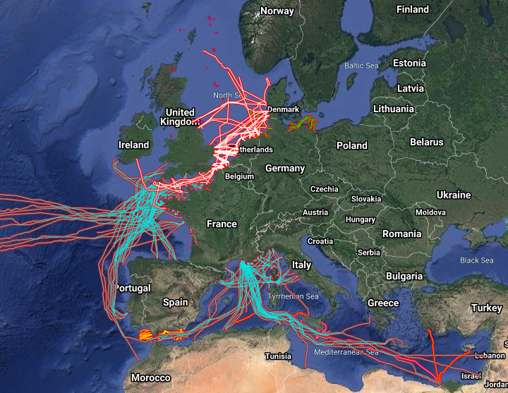
EMODnet Human Activities, Telecommunication and power cables, Actual Routes
The datasets on subsea telecommunication and power cables (actual routes) in the EU was created in 2014 by Cogea for the European Marine Observation and Data Network (EMODnet). It is the result of the aggregation and harmonization of datasets provided by several sources. It is updated every year and is available for viewing and download on EMODnet Human Activities web portal (www.emodnet-humanactivities.eu). The datasets contain lines representing actual cable routes locations. Compared with the previous version, this version includes an update of the French telecommunication cables, the telecommunication cables that originate from or pass through Spanish (Andalucia) and Dutch waters, and the electric cables that originate from or pass through French, Dutch and Norwegian waters.
Simple
- Title
-
EMODnet Human Activities, Telecommunication and power cables, Actual Routes
- Date (Publication)
- 2015-01-15
- Date (Revision)
- 2021-01-26
- Date (Creation)
- 2014-12-22
- Citation identifier
- EMODnet_HA_Cables_20210126
- Abstract
-
The datasets on subsea telecommunication and power cables (actual routes) in the EU was created in 2014 by Cogea for the European Marine Observation and Data Network (EMODnet). It is the result of the aggregation and harmonization of datasets provided by several sources. It is updated every year and is available for viewing and download on EMODnet Human Activities web portal (www.emodnet-humanactivities.eu). The datasets contain lines representing actual cable routes locations. Compared with the previous version, this version includes an update of the French telecommunication cables, the telecommunication cables that originate from or pass through Spanish (Andalucia) and Dutch waters, and the electric cables that originate from or pass through French, Dutch and Norwegian waters.
- Credit
-
European Marine Observation and Data Network
- Point of contact
-
Organisation name Individual name Electronic mail address Role Cogea srl
Author Germany - Federal Maritime and Hydrographic Agency
Production Unit Spain - Centro Informático Científico de Andalucía (CICA)
Production Unit France - SIGCables - Orange ©
Production Unit France - Service hydrographique et océanographique de la Marine (Shom)
Production Unit Malta - International Ocean Institute - Malta Operational Centre (University Of Malta) / Physical Oceanography Unit
Netherlands - Rijkswaterstaat
Norway - Norwegian Water Resources and Energy Directorate (NVE)
Production Unit United Kingdom - Oil and Gas Authority (OGA)
Production Unit EMODnet
Publisher
-
GEMET - INSPIRE themes, version 1.0
-
-
utilitiesCommunication
-
Utility and governmental services
-
-
Mission Atlantic - Resources
-
-
Data
-
-
Mission Atlantic - Case Studies
-
-
Celtic Seas
-
North Mid-Atlantic Ridge
-
-
Mission Atlantic - Work Package
-
-
WP3 Pelagic Mapping
-
WP4 Benthic Mapping
-
-
Mission Atlantic - BODC Parameters
-
-
/Human activities/Cables
-
-
Mission Atlantic - Data type (DMP)
-
-
Spatial data products
-
- Use limitation
-
Re-use of content for commercial or non-commercial purposes is permitted free of charge, provided that the sources (both EMODnet - Human Activities, and primary sources) are acknowledged. EMODnet - Human Activities accepts no responsibility or liability whatsoever for the re-use of content accessible on its website.
- Access constraints
- Other restrictions
- Other legal constraints
-
no limitation
- Spatial representation type
- Vector
- Denominator
- 100000
- Language
- English
- Topic category
-
- Planning cadastre
- Utilities communication
))
- Reference system identifier
- EPSG:4326
- Reference system identifier
- ISO 19108 calendar
- Distribution format
-
Name Version ESRI Shapefile
1.0
- Transfer size (in MB)
- 0
- OnLine resource
-
Protocol Linkage Name WWW:LINK
http://www.emodnet-humanactivities.eu EMODnet Human Activities
- Hierarchy level
- Dataset
Conformance result
- Title
-
COMMISSION REGULATION (EC) No 1205/2008 of 3 December 2008 implementing Directive 2007/2/EC of the European Parliament and of the Council as regards metadata
- Date (Publication)
- 2008-12-04
- Explanation
-
See the referenced specification
- Pass
Conformance result
- Title
-
Commission Regulation (EU) No 1089/2010 of 23 November 2010 implementing Directive 2007/2/EC of the European Parliament and of the Council as regards interoperability of spatial data sets and services
- Date (Publication)
- 2010-12-08
- Explanation
-
See the referenced specification
Conformance result
- Title
-
Corrigendum to INSPIRE Metadata Regulation published in the Official Journal of the European Union, L 328, page 83
- Date (Publication)
- 2009-12-15
- Explanation
-
See the referenced specification
- Pass
- Statement
-
Data were retrived from 8 different sources. Validation and quality assurance remain up to the primary sources. Cogea simply retrieved the information available online, except for Maltese cables that have been edited ina shapefile using tabular data of coordinates submitted via EMODnet Data Ingestion portal by the International Ocean Institute-Malta Operational Centre (University Of Malta)/Physical Oceanography Unit.
Metadata
- File identifier
- EMODnet_HA_Cables_20210126
- Metadata language
- English
- Character set
- UTF8
- Hierarchy level
- Dataset
- Date stamp
- 2022-02-23T10:42:57.984Z
- Metadata standard name
-
ISO19115
- Metadata standard version
-
2003/Cor.1:2006
- Metadata author
-
Organisation name Individual name Electronic mail address Role Cogea srl
Local service desk
accessData
Overviews
)))