DGMW Ems Model A (1m)
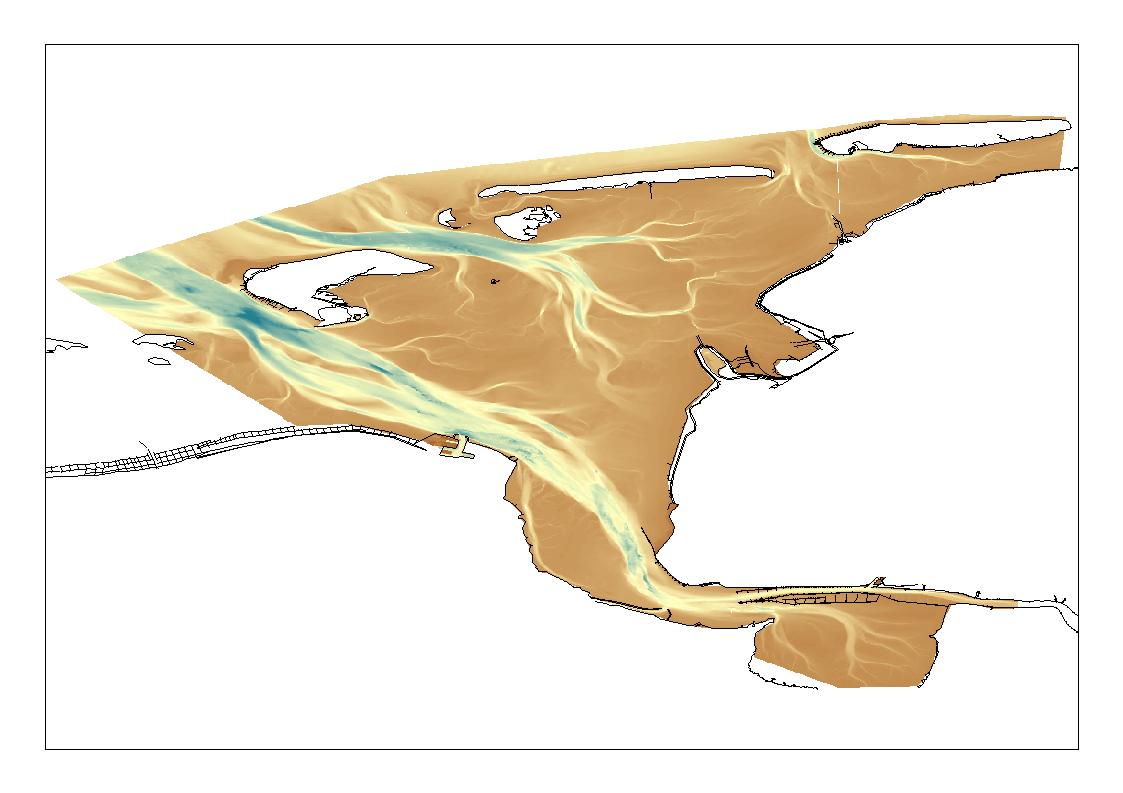
High Resolution DTM of the German Ems Approach.
Simple
- Title
-
DGMW Ems Model A (1m)
- Alternate title
-
DGMW_UAEMS
- Date (Creation)
- 2012-01-31
- Date (Revision)
- Citation identifier
- DGMW_UAEMS
- Abstract
-
High Resolution DTM of the German Ems Approach.
- Point of contact
-
Organisation name Individual name Electronic mail address Role Federal Maritime and Hydrographic Agency
Product manager Federal Maritime and Hydrographic Agency
Production center
-
Project name
-
-
EMODNet Bathymetry
-
-
SeaDataNet device categories
-
-
single-beam echosounders
-
multi-beam echosounders
-
-
SeaDataNet device categories
-
-
Differential Global Positioning System receivers
-
-
Parameter Discovery Vocabulary (P02)
-
-
Bathymetry and Elevation
-
-
GEMET - INSPIRE themes, version 1.0
-
-
Hydrography
-
- Access constraints
- License
- Use constraints
- Copyright
- Spatial representation type
- Grid
- Denominator
- 5000
- Distance
- 1 Metres (m)
- Language
- English
- Character set
- UTF8
- Topic category
-
- Oceans
- Begin date
- 2010-03-18
- End date
- 2011-09-24
))
- Geographic identifier
- North Sea
- Description
-
Map projection parameters, values and units :
Axes units :
- Geographic identifier
- EPSG / UTM-32 / 7.4
- Reference system identifier
- EPSG / ETRS89 (EPSG:4258) / 7.4
- Number of dimensions
- 3
- Dimension name
- Column
- Dimension size
- 1000000
- Dimension name
- Row
- Dimension size
- 1000000
- Dimension name
- Time
- Dimension size
- 1
- Cell geometry
- Point
- Transformation parameter availability
- Checkpoint Availability
- Point in Pixel
-
- Center
- Distribution format
-
Name Version ASCII grid
- Distributor contact
-
Organisation name Individual name Electronic mail address Role Federal Maritime and Hydrographic Agency
Dissemination Unit
- Transfer size (in MB)
- 10.5 GB
- OnLine resource
-
Protocol Linkage Name WWW:LINK
https://www.bsh.de/
- Hierarchy level
- Dataset
Vertical extent
- Minimum value
- 30.7
- Maximum value
- -30.14
Vertical CRS
Vertical CS
Vertical datum
- Statement
-
no information
- Hierarchy level
- Feature
- Dataset
-
accuracy
Gridded data positional accuracy
- Name of measure
-
horizontal accuracy
- Measure identification
- horizontal accuracy of coordinate
Quantitative result
- Value type
- horizontal accuracy
Quantitative attribute accuracy
- Name of measure
-
depth
- Measure identification
- depth accuracy
Quantitative result
- Value
- not defined
Conformance result
- Title
-
Shoal bias
- Date
- Hierarchy level
- Software
- Other
-
software
- Hierarchy level
- Property type
- Description
-
parameters of data processing
Attributes
- Statement
-
Description of data processing :The Digital Terrain Model Waterways project serves the purpose to gather, process and shape topographical data. Aquisition of data took place by single and multi beam echosunders as well as Airborne Laserscanning. After processing and harmonisation the data was compiled and suplemented by structure information. Results of this process chain is in the first place a 1*1m² raster (Model A) and in the second place a reduced and less accurate Tringulated Irregular Network (Model B) derived from this grid. The Model A exists in multiple tiles of 1km*1km.
- Description
-
Description of processed data sources :
- Hierarchy level
- Dataset
- Horizontal Quality Indicator
- 3 - < 20 m
- Vertical Quality Indicator
- 3 - Lidar, SBES high frequency
- Purpose Quality Indicator
- 3 - Hydrographic survey or compatible with hydrographic standards
Metadata
- File identifier
- SDN_CPRD_1850_DGMW_UAEMS
- Metadata language
- English
- Character set
- UTF8
- Hierarchy level name
-
Composite Product Record
- Date stamp
- 2025-04-10T13:06:19.796556Z
- Metadata standard name
-
ISO 19115:2003/19139 - EMODNET - BATHYMETRY
- Metadata standard version
-
1.0
- Metadata author
-
Organisation name Individual name Electronic mail address Role Federal Maritime and Hydrographic Agency
Author
accessData
Overviews
)))