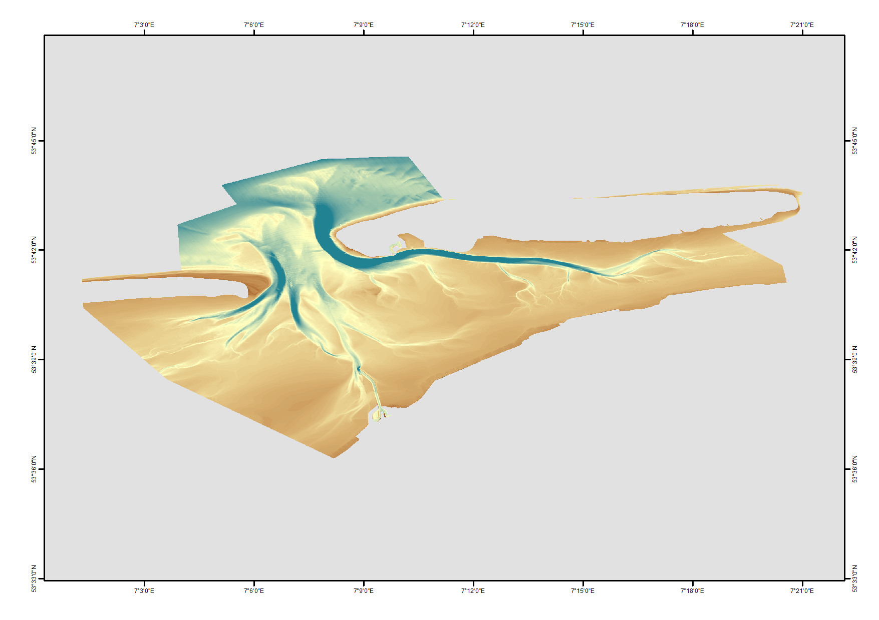
1850 HRDTM 1/512 Norderney
High resolution composite DTM based on single beam, multi beam and Lidar covering Norderney and waters in proximty. All data was acquired in the year 2016.
Data used:SDN:CPRD:1850_DGM_Norderney_2016
Simple
- Title
-
1850 HRDTM 1/512 Norderney
- Alternate title
-
DGM_Norderney_2016
- Date (Creation)
- Date (Revision)
- Citation identifier
- DGM_Norderney_2016
- Abstract
-
High resolution composite DTM based on single beam, multi beam and Lidar covering Norderney and waters in proximty. All data was acquired in the year 2016.
Data used:SDN:CPRD:1850_DGM_Norderney_2016
- Point of contact
-
Organisation name Individual name Electronic mail address Role Federal Maritime and Hydrographic Agency
Product manager Federal Maritime and Hydrographic Agency
Production center
-
Project name
-
-
EMODnet HRSM
-
-
SeaDataNet device categories
-
-
multi-beam echosounders
-
multi-beam echosounders
-
-
SeaDataNet device categories
-
-
Differential Global Positioning System receivers
-
-
Parameter Discovery Vocabulary (P02)
-
-
Bathymetry and Elevation
-
-
GEMET - INSPIRE themes, version 1.0
-
-
Hydrography
-
- Access constraints
- Creative Commons Attribution 4.0 International
- Use constraints
- Other restrictions
- Other legal constraints
-
DO NOT USE FOR NAVIGATION
- Spatial representation type
- Grid
- Denominator
- 5000
- Distance
- 0.00195313 Arc minute
- Language
- English
- Character set
- UTF8
- Topic category
-
- Oceans
))
- Geographic identifier
- North Sea
- Description
-
Map projection parameters, values and units :
Axes units :
- Geographic identifier
- EPSG / ETRS89-UTM32 / 7.4
- Reference system identifier
- EPSG: 25832 / ETRS89 (GRS80) / 7.4
- Number of dimensions
- 3
- Dimension name
- Column
- Dimension size
- 21784
- Dimension name
- Row
- Dimension size
- 15391
- Dimension name
- Time
- Dimension size
- 1
- Cell geometry
- Point
- Transformation parameter availability
- Checkpoint Availability
- Point in Pixel
-
- Center
- Distribution format
-
Name Version ASCII/NetCDF
- Distributor contact
-
Organisation name Individual name Electronic mail address Role Federal Maritime and Hydrographic Agency
Dissemination Unit
- Transfer size (in MB)
- 400
- OnLine resource
-
Protocol Linkage Name WWW:LINK
https://emodnet.ec.europa.eu/geoviewer EMODnet viewer
WWW:LINK
https://tiles.emodnet-bathymetry.eu/ EMODnet Bathymetry WMTS service
WWW:DOWNLOAD-1.0-link--download
https://downloads.emodnet-bathymetry.eu/high_resolution/1850_norderney_a1.emo.zip norderney_a1 - Format EMO
WWW:DOWNLOAD-1.0-link--download
https://downloads.emodnet-bathymetry.eu/high_resolution/1850_norderney_c1.emo.zip norderney_c1 - Format EMO
- OnLine resource
-
Protocol Linkage Name WWW:DOWNLOAD-1.0-link--download
https://downloads.emodnet-bathymetry.eu/high_resolution/1850_norderney_b1.emo.zip norderney_b1 - Format EMO
- Hierarchy level
- Dataset
Vertical extent
Vertical CRS
Vertical CS
Vertical datum
- Statement
-
no information
- Hierarchy level
- Feature
- Dataset
-
accuracy
Gridded data positional accuracy
- Name of measure
-
horizontal accuracy
- Measure identification
- horizontal accuracy of coordinate
Quantitative result
- Value type
- horizontal accuracy
- Value
- ≤ 0.4m
Quantitative attribute accuracy
- Name of measure
-
depth
- Measure identification
- depth accuracy
Quantitative result
- Value
- not defined
Conformance result
- Title
-
Shoal bias
- Date
- Hierarchy level
- Software
- Other
-
software
- Hierarchy level
- Property type
- Description
-
parameters of data processing
Attributes
Metadata
- File identifier
- SDN_CPRD_1850_DGM_Norderney_2016
- Metadata language
- English
- Character set
- UTF8
- Hierarchy level name
-
Composite Product Record
- Date stamp
- 2023-05-05T08:37:10.572Z
- Metadata standard name
-
ISO 19115:2003/19139 - EMODNET - BATHYMETRY
- Metadata standard version
-
1.0
- Metadata author
-
Organisation name Individual name Electronic mail address Role Federal Maritime and Hydrographic Agency
Author
accessData
Overviews
)))