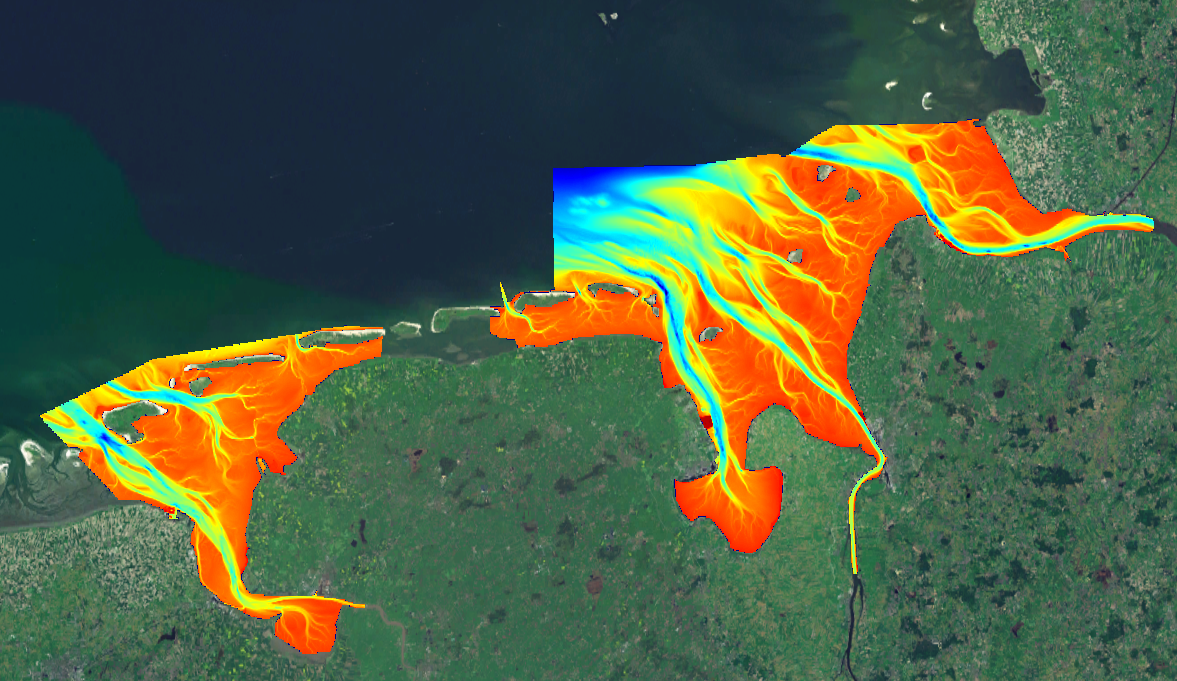
1850_North Sea - German Approaches DTM
Composite DTM created from five high resolution DTMs in the german approaches. Due to the high resolution (1m*1m) of the original data this DTM has been generalized to a horizontal resolution of approx. 115m.
Simple
- Title
-
1850_North Sea - German Approaches DTM
- Alternate title
-
GERMANY_DTM_GA_DGMW
- Date (Creation)
- Date (Revision)
- Citation identifier
- GERMANY_DTM_GA_DGMW
- Abstract
-
Composite DTM created from five high resolution DTMs in the german approaches. Due to the high resolution (1m*1m) of the original data this DTM has been generalized to a horizontal resolution of approx. 115m.
- Point of contact
-
Organisation name Individual name Electronic mail address Role Federal Maritime and Hydrographic Agency (BSH)
Product manager Federal Maritime and Hydrographic Agency (BSH)
Production center
-
Project name
-
-
EMODNet Bathymetry
-
-
SeaDataNet device categories
-
-
single-beam echosounders
-
-
SeaDataNet device categories
-
-
Differential Global Positioning System receivers
-
-
Parameter Discovery Vocabulary (P02)
-
-
Bathymetry and Elevation
-
-
GEMET - INSPIRE themes, version 1.0
-
-
Hydrography
-
- Use limitation
-
unrestricted
- Other legal constraints
-
Unrestricted
- Use limitation
-
Not for Navigation
- Spatial representation type
- Grid
- Denominator
- 25000
- Distance
- 3.75 Arc minutes (arc_min)
- Language
- English
- Character set
- UTF8
- Topic category
-
- Oceans
- Begin date
- 2010-01-01
- End date
- 2014-05-04
))
- Geographic identifier
- North Sea
- Reference system identifier
- EPSG / WGS 84 (EPSG:4326) / 7.4
- Number of dimensions
- 3
- Dimension name
- Column
- Dimension size
- 2656
- Dimension name
- Row
- Dimension size
- 752
- Dimension name
- Time
- Dimension size
- 1
- Cell geometry
- Point
- Transformation parameter availability
- Checkpoint Availability
- Point in Pixel
-
- Center
- Distribution format
-
Name Version Ascii
Emodnet format
- Distributor contact
-
Organisation name Individual name Electronic mail address Role Federal Maritime and Hydrographic Agency (BSH)
Dissemination Unit
- Transfer size (in MB)
- 35
- OnLine resource
-
Protocol Linkage Name WWW:LINK
http://www.bsh.de
- Hierarchy level
- Dataset
Vertical extent
- Minimum value
- -12
- Maximum value
- 37
Vertical CRS
Vertical CS
Vertical datum
- Statement
-
no information
- Hierarchy level
- Feature
- Dataset
-
accuracy
Gridded data positional accuracy
- Name of measure
-
horizontal accuracy
- Measure identification
- horizontal accuracy of coordinate
Quantitative attribute accuracy
- Name of measure
-
depth
- Measure identification
- depth accuracy
Quantitative result
- Value
- not defined
Conformance result
- Title
-
Shoal bias
- Date
- Hierarchy level
- Software
- Description
-
ArcGIS, GLOBE
- Other
-
software
- Hierarchy level
- Property type
- Description
-
parameters of data processing
Attributes
- Statement
-
Description of data processing :The source DTM heights have been converted from DHHN92 heights to LAT Depths in ArcGIS; the CRS has been transformed from ETRS89-UTM32 to WGS'84 . The resulting dataset has been reduced and merged via GLOBE.
- Description
-
Description of processed data sources :
- Hierarchy level
- Dataset
- Horizontal Quality Indicator
- 3 - < 20 m
- Vertical Quality Indicator
- 3 - Lidar, SBES high frequency
- Purpose Quality Indicator
- 3 - Hydrographic survey or compatible with hydrographic standards
Metadata
- File identifier
- SDN_CPRD_1850_GERMANY_DTM_GA_DGMW
- Metadata language
- English
- Character set
- UTF8
- Hierarchy level name
-
Composite Product Record
- Date stamp
- 2018-01-23T10:14:37
- Metadata standard name
-
ISO 19115:2003/19139 - EMODNET - BATHYMETRY
- Metadata standard version
-
1.0
- Metadata author
-
Organisation name Individual name Electronic mail address Role Federal Maritime and Hydrographic Agency (BSH)
Author
accessData
Overviews
)))