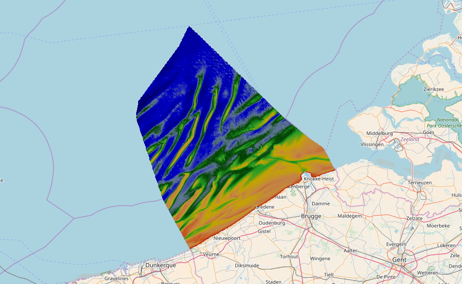
2243_EMODNet Regional DTM of the Belgium Continental Shelf (Version 6)
Source data for the EMODNet DTM for the Belgium Continental Shelf (BCP) is compiled by the Vlaamse Hydrografie ( http://www.afdelingkust.be/en/bathymetric-database) at a resolution of 1/64".
The data set covers the Belgium Continental shelf area.
Simple
- Title
-
2243_EMODNet Regional DTM of the Belgium Continental Shelf (Version 6)
- Alternate title
-
BELGIUM_BCP_DTM061017
- Date (Creation)
- 2017-10-06T10:45:00
- Date (Revision)
- 2017-10-09T14:45:00
- Citation identifier
- BELGIUM_BCP_DTM061017
- Abstract
-
Source data for the EMODNet DTM for the Belgium Continental Shelf (BCP) is compiled by the Vlaamse Hydrografie ( http://www.afdelingkust.be/en/bathymetric-database) at a resolution of 1/64".
The data set covers the Belgium Continental shelf area.
- Point of contact
-
Organisation name Individual name Electronic mail address Role Flemish Ministry of Mobility and Public Works; Agency for Maritime and Coastal Services; Coastal Division
Product manager Flemish Ministry of Mobility and Public Works; Agency for Maritime and Coastal Services; Coastal Division
Production center
-
Project name
-
-
EMODnet HRSM
-
-
SeaDataNet device categories
-
-
single-beam echosounders
-
-
SeaDataNet device categories
-
-
multi-beam echosounders
-
-
Parameter Discovery Vocabulary (P02)
-
-
Bathymetry and Elevation
-
-
GEMET - INSPIRE themes, version 1.0
-
-
Hydrografie
-
- Use limitation
-
See disclaimer: http://www.afdelingkust.be/en/disclaimer
- Access constraints
- License
- Use constraints
- Copyright
- Use limitation
-
Data is owned by Vlaamse Hydrografie. Please refer to http://www.afdelingkust.be/en/disclaimer for terms of use.
- Spatial representation type
- Grid
- Denominator
- 500000
- Distance
- 60 Metres (m)
- Language
- English
- Character set
- UTF8
- Topic category
-
- Oceans
- Begin date
- 2008-06-10T09:00:00
- End date
- 2017-09-27T17:00:00
))
- Geographic identifier
- North Sea
- Description
-
Map projection parameters, values and units :
Axes units :
- Geographic identifier
- EPSG / Not projected / 7.4
- Reference system identifier
- EPSG / ETRS89 (EPSG:4258) /
- Number of dimensions
- 3
- Dimension name
- Column
- Dimension size
- 678
- Dimension name
- Row
- Dimension size
- 760
- Dimension name
- Time
- Dimension size
- 1
- Cell geometry
- Point
- Transformation parameter availability
- Checkpoint Availability
- Point in Pixel
-
- Center
- Distribution format
-
Name Version GeoTIFF, BAG, image/png, image/jpeg and text/csv
5.9
- Distributor contact
-
Organisation name Individual name Electronic mail address Role Flemish Ministry of Mobility and Public Works; Agency for Maritime and Coastal Services; Coastal Division
Dissemination Unit
- Transfer size (in MB)
- 630
- OnLine resource
-
Protocol Linkage Name WWW:LINK
http://www.afdelingkust.be/en/bathymetric-database Dataportal Bathymetry - Vlaamse Hydrografie
- Hierarchy level
- Dataset
Vertical extent
- Minimum value
- -5.10
- Maximum value
- 46.10
Vertical CRS
Vertical CS
Vertical datum
- Statement
-
no information
- Hierarchy level
- Feature
- Dataset
-
accuracy
Gridded data positional accuracy
- Name of measure
-
horizontal accuracy
- Measure identification
- horizontal accuracy of coordinate
- Measure description
-
IHO S-44
- Evaluation method description
-
IHO S-44
Quantitative result
- Value type
- horizontal accuracy
- Value
- IHO S-44
Quantitative attribute accuracy
- Name of measure
-
depth
- Measure identification
- depth accuracy
- Measure description
-
IHO S-44
- Evaluation method description
-
IHO S-44
Quantitative result
- Value
- not defined
Conformance result
- Title
-
Shoal bias
- Date
- Pass
- Hierarchy level
- Software
- Description
-
CARIS BathyDatabase software suite
- Other
-
software
- Hierarchy level
- Property type
- Description
-
parameters of data processing
Attributes
- Statement
-
Description of data processing :
The original data is delivered in longitude/latitude (non projected) coordinates in the EMODnet format adding the required field using the CARIS BathyDatabase software suite.
List of the survey projects used to combine the EmodNet Regional DTM (version 6):
080000_FAIRY_SB_33.xml
110000_ZUYWE_SB_33.xml
110700_NBCP_CENTRAAL_MB_300.xml
120000_FAIRY_SB_33.xml
120800_NBCP_NOORD_MB_300.xml
130200_A1_A1B_SB_33.xml
131008_PVZ_MB_300.xml
140206_ZUYWE_SB_33.xml
150121_BKBZB_MB_400.xml
150123_VG1_MB_300.xml
150126_WEDHA_SB_33.xml
150605_DHAWD_SB_200.xml
150707_A1_A1B_MB_300.xml
150720_NBCP_NOORD_MB_300.xml
150802_NBCP_CENTRAAL_MB_400.xml
150808_S511_MB_300.xml
150811_NBCP_ZUID_MB_400.xml
150821_NBCP_CENTRAAL_MB_400.xml
151003_NBCP_NOORD_MB_400.xml
151005_BWS1_SB_33.xml
151009_WHAG_MB_400.xml
151130_NPT_HAV_MB_455.xml
160218_NLCP_MB_400.xml
160311_BWO_SB_33.xml
160510_NNO_MB_300.xml
160622_A1_A1B_MB_300.xml
160920_ZB_STRD_MB_300.xml
161011_GOOT_MB_300.xml
161129_WHBO_MB_300.xml
161205_OST_HAV_SB_33.xml
161207_GOOT_MB_300.xml
170118_WHBO_MB_300.xml
170206_KWIMID_MB_300.xml
170209_WIESCH_MB_300.xml
170215_BLI_MB_300.xml
170322_ZUYWE_MB_400.xml
170323_ZB_STRD_MB_300.xml
170327_AVG1_MB_300.xml
170327_KWIMID_MB_300.xml
170328_WHBO_MB_300.xml
170328_ZUYWE_MB_400.xml
170329_ZUYWE_MB_300.xml
170331_ZUYWE_MB_400.xml
170402_BLI_MB_300.xml
170411_NNO_MB_300.xml
170414_RO_MB_300.xml
170502_SCHW_MB_300.xml
170503_ZUYWE_MB_300.xml
170522_HEIZW_SB_200.xml
170524_BKBZB_SB_200.xml
170531_VG1_MB_300.xml
170531_WEDHA_MB_300.xml
170601_OSTBRE_SB_200.xml
170609_WEDHA_MB_300.xml
170613_STV_BWS1_SB_33.xml
170614_BWO_SB_33.xml
170614_MKOST_SB_200.xml
170614_ODKMK_SB_200.xml
170620_DPODK_SB_200.xml
170627_NPT_SB_33.xml
170627_WEDHA_MB_300.xml
170627_WIESCH_MB_300.xml
170629_ASCH_MB_400.xml
170629_DHAWD_SB_200.xml
170630_A1_A1B_MB_400.xml
170704_BWS2_SB_33.xml
170706_WEDHA_MB_300.xml
170713_BKB_HAV_MB_400.xml
170724_NPT_HAV_MB_400.xml
170807_PVZ_SB_33.xml
170810_SCHO_MB_300.xml
170821_WHBO_MB_300.xml
170828_BWS1_SB_33.xml
170828_BWZBO_SB_33.xml
170831_PVS_SB_33.xml
170904_SCHW_MB_300.xml
170905_WIESCH_MB_300.xml
170905_ZB_CDNBKOP_SB_33.xml
170920_WHBO_MB_300.xml
170926_BKBZB_SB_200.xml
170926_VG1_MB_300.xml
170927_ODKMK_MB_400.xml
- Description
-
Description of processed data sources : Description of processed data sources: various single and multi beam surveys collected for compilation of nautical charts.
- Hierarchy level
- Dataset
- Horizontal Quality Indicator
- 3 - < 20 m
- Vertical Quality Indicator
- -1 - Multisources
- Purpose Quality Indicator
- 3 - Hydrographic survey or compatible with hydrographic standards
Metadata
- File identifier
- SDN_CPRD_2243_BELGIUM_BCP_DTM061017
- Metadata language
- English
- Character set
- UTF8
- Hierarchy level name
-
Composite Product Record
- Date stamp
- 2018-10-09T14:56:56
- Metadata standard name
-
ISO 19115:2003/19139 - EMODNET - BATHYMETRY
- Metadata standard version
-
1.0
- Metadata author
-
Organisation name Individual name Electronic mail address Role Flemish Ministry of Mobility and Public Works; Agency for Maritime and Coastal Services; Coastal Division
Author
accessData
Overviews
)))