2243_EMODNet Regional DTM of the Belgium Continental Shelf (Version 4)
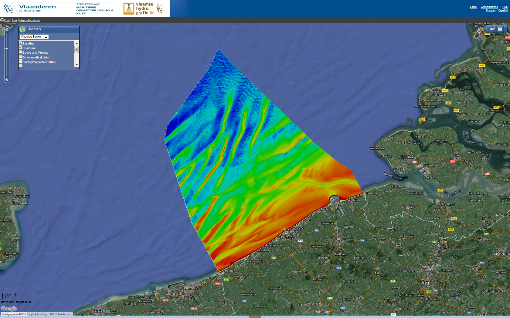
Source data for the EMODNet DTM for the Belgium Continental Shelf (BCP) is compiled by the Vlaamse Hydrografie ( http://www.vlaamsehydrografie.be/) at a resolution of 60x60 meter.
The data set covers the Belgium Continental shelf area.
Simple
- Title
-
2243_EMODNet Regional DTM of the Belgium Continental Shelf (Version 4)
- Alternate title
-
BELGIUM_BCP_DTM100216
- Date (Creation)
- 2016-01-10T14:30:00
- Date (Revision)
- 2016-01-25T14:30:00
- Citation identifier
- BELGIUM_BCP_DTM100216
- Abstract
-
Source data for the EMODNet DTM for the Belgium Continental Shelf (BCP) is compiled by the Vlaamse Hydrografie ( http://www.vlaamsehydrografie.be/) at a resolution of 60x60 meter.
The data set covers the Belgium Continental shelf area.
- Point of contact
-
Organisation name Individual name Electronic mail address Role Flemish Ministry of Mobility and Public Works; Agency for Maritime and Coastal Services; Coastal Division
Product manager Flemish Ministry of Mobility and Public Works; Agency for Maritime and Coastal Services; Coastal Division
Production center
-
Project name
-
-
EMODNet Bathymetry
-
-
SeaDataNet device categories
-
-
single-beam echosounders
-
multi-beam echosounders
-
-
SeaDataNet device categories
-
-
Differential Global Positioning System receivers
-
-
Parameter Discovery Vocabulary (P02)
-
-
Bathymetry and Elevation
-
-
GEMET - INSPIRE themes, version 1.0
-
-
Hydrography
-
- Use limitation
-
See disclaimer http://www.vlaamsehydrografie.be/disclaimer.asp?TAAL_ID=1
- Access constraints
- License
- Use constraints
- Copyright
- Use limitation
-
Data is owned by Vlaamse Hydrografie. Please refer to www.vlaamsehydrografie.be for terms of use.
- Spatial representation type
- Grid
- Denominator
- 500000
- Distance
- 60 Metres (m)
- Language
- English
- Character set
- UTF8
- Topic category
-
- Oceans
- Begin date
- 2004-01-15T09:00:00
- End date
- 2016-01-28T17:00:00
))
- Geographic identifier
- North Sea
- Description
-
Map projection parameters, values and units :
Axes units :
- Geographic identifier
- EPSG / Not projected / 7.4
- Reference system identifier
- EPSG / WGS 84 (EPSG:4326) / 7.9
- Number of dimensions
- 3
- Dimension name
- Column
- Dimension size
- 678
- Dimension name
- Row
- Dimension size
- 760
- Dimension name
- Time
- Dimension size
- 1
- Cell geometry
- Point
- Transformation parameter availability
- Checkpoint Availability
- Point in Pixel
-
- Center
- Distribution format
-
Name Version GeoTIFF, BAG, image/png, image/jpeg and text/csv
5.9
- Distributor contact
-
Organisation name Individual name Electronic mail address Role Flemish Ministry of Mobility and Public Works; Agency for Maritime and Coastal Services; Coastal Division
Dissemination Unit
- Transfer size (in MB)
- 314
- Hierarchy level
- Dataset
Vertical extent
- Minimum value
- -3.58
- Maximum value
- 45.97
Vertical CRS
Vertical CS
Vertical datum
- Statement
-
no information
- Hierarchy level
- Feature
- Dataset
-
accuracy
Gridded data positional accuracy
- Name of measure
-
horizontal accuracy
- Measure identification
- horizontal accuracy of coordinate
- Measure description
-
IHO S-44
- Evaluation method description
-
IHO S-44
Quantitative result
- Value type
- horizontal accuracy
- Value
- IHO S-44
Quantitative attribute accuracy
- Name of measure
-
depth
- Measure identification
- depth accuracy
- Measure description
-
IHO S-44
- Evaluation method description
-
IHO S-44
Quantitative result
- Value
- not defined
Conformance result
- Title
-
Shoal bias
- Date
- Pass
- Hierarchy level
- Software
- Description
-
CARIS BathyDatabase software suite
- Other
-
software
- Hierarchy level
- Property type
- Description
-
parameters of data processing
Attributes
- Statement
-
Description of data processing :
The original data is delivered in longitude/latitude (non projected) coordinates in the EMODnet format adding the required field using the CARIS BathyDatabase software suite.
List of the survey projects used to combine the EmodNet Regional DTM (version4):
150226_ASCH_MB_300.xml
150310_AK_MB_300.xml
150310_OSTDYAG_MB_455.xml
150313_WHVR_O_MB_455.xml
150403_SCHO_MB_300.xml
150405_WHVR_M_MB_455.xml
150413_NLCP_MB_400.xml
150508_KWGS_MB_400.xml
150508_KWIMID_MB_400.xml
150508_RAAN_MB_300.xml
150510_WHVR_W_MB_400.xml
150513_DPODK_SB_200.xml
150513_NBCP_TWIN_MB_400.xml
150513_RAAN_MB_300.xml
150521_NNO_MB_300.xml
150522_ODKMK_SB_200.xml
150604_BKBZB_SB_200.xml
150604_MKOST_SB_200.xml
150605_DHAWD_SB_200.xml
150605_OSTBRE_SB_200.xml
150616_HEIZW_SB_200.xml
150617_ZB_STRD_MB_300.xml
150624_HEIZW_MB_400.xml
150630_RO_MB_300.xml
150702_NPT_SB_33.xml
150703_BWZBO_SB_33.xml
150707_A1_A1B_MB_300.xml
150710_WIESCH_MB_300.xml
150716_NLCP_MB_400.xml
150720_BKBZB_MB_400.xml
150720_NBCP_NOORD_MB_300.xml
150730_MKOST_MB_400.xml
150802_NBCP_CENTRAAL_MB_400.xml
150802_RAAN_MB_300.xml
150803_BWO_SB_33.xml
150810_BWS2_SB_33.xml
150811_NBCP_ZUID_MB_400.xml
150821_NBCP_CENTRAAL_MB_400.xml
150828_S511_MB_300.xml
150831_SCHW_MB_300.xml
150910_ZB_STRD_MB_300.xml
151003_AVG1_MB_300.xml
151003_NBCP_NOORD_MB_400.xml
151005_BWS1_SB_33.xml
151008_SCHW_MB_300.xml
151009_WHAG_MB_400.xml
151019_NLCP_MB_300.xml
151101_WHVR_W_MB_300.xml
151104_RAAN_MB_300.xml
151130_NPT_HAV_MB_455.xml
151228_SCHO_MB_300.xml
151230_BWZBO_SB_33.xml
160106_PVZ_SB_33.xml
160118_BWS1_SB_33.xml
160119_VG1_MB_300.xml
160119_ZB_CDNBKOP_SB_33.xml
160122_PVS_SB_33.xml
160125_OST_HAV_SB_33.xml
160128_BKB_HAV_MB_300.xml
- Description
-
Description of processed data sources : Description of processed data sources: various single and multi beam surveys collected for compilation of nautical charts.
- Hierarchy level
- Dataset
- Horizontal Quality Indicator
- 3 - < 20 m
- Vertical Quality Indicator
- -1 - Multisources
- Purpose Quality Indicator
- 3 - Hydrographic survey or compatible with hydrographic standards
Metadata
- File identifier
- SDN_CPRD_2243_BELGIUM_BCP_DTM100216
- Metadata language
- English
- Character set
- UTF8
- Hierarchy level name
-
Composite Product Record
- Date stamp
- 2018-11-06T13:37:47
- Metadata standard name
-
ISO 19115:2003/19139 - EMODNET - BATHYMETRY
- Metadata standard version
-
1.0
- Metadata author
-
Organisation name Individual name Electronic mail address Role Flemish Ministry of Mobility and Public Works; Agency for Maritime and Coastal Services; Coastal Division
Author
accessData
Overviews
)))