269_DTM_SantoriniArea
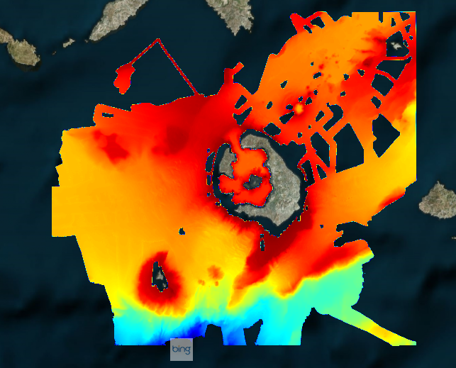
The DTM is a compilation of multibeam echosounder surveys at Central Aegean Sea - around Santorini Island (Greece), acquired with R/V Aegaeo using Seabeam 2120 (20 kHz) echosounder during 2001, 2006, 2016 and 2017 cruises. Grid resolution is 1/32 arc-minutes processed for the purpose of the HR DTMs layer of EMODnet Bathymetry HRSM, October 2018.
Simple
- Title
-
269_DTM_SantoriniArea
- Alternate title
-
EMODNET-IFR-WESTMED-2012
- Date (Creation)
- 2018-10-24
- Citation identifier
- SantoriniArea
- Abstract
-
The DTM is a compilation of multibeam echosounder surveys at Central Aegean Sea - around Santorini Island (Greece), acquired with R/V Aegaeo using Seabeam 2120 (20 kHz) echosounder during 2001, 2006, 2016 and 2017 cruises. Grid resolution is 1/32 arc-minutes processed for the purpose of the HR DTMs layer of EMODnet Bathymetry HRSM, October 2018.
- Point of contact
-
Organisation name Individual name Electronic mail address Role Hellenic Centre for Marine Research, Institute of Oceanography (HCMR/IO)
Product manager Hellenic Centre for Marine Research, Hellenic National Oceanographic Data Centre (HCMR/HNODC)
Production center
-
Project name
-
-
EMODnet HRSM
-
-
SeaDataNet device categories
-
-
multi-beam echosounders
-
-
Parameter Discovery Vocabulary (P02)
-
-
Bathymetry and Elevation
-
-
GEMET - INSPIRE themes, version 1.0
-
-
Hydrography
-
- Access constraints
- Creative Commons Attribution 4.0 International
- Use constraints
- Other restrictions
- Other legal constraints
-
DO NOT USE FOR NAVIGATION
- Spatial representation type
- Grid
- Denominator
- 50000
- Distance
- 0.03125 Arc minute
- Language
- English
- Character set
- UTF8
- Topic category
-
- Oceans
- Begin date
- 2002
- End date
- 2006
))
- Description
-
Map projection parameters, values and units :
Axes units :
- Codespace
-
EPSG
- Version
-
7.4
- Reference system identifier
- EPSG / WGS 84 (EPSG:4326) / 7.4
- Number of dimensions
- 3
- Dimension name
- Column
- Dimension size
- 1376
- Dimension name
- Row
- Dimension size
- 1056
- Dimension name
- Time
- Dimension size
- 1
- Cell geometry
- Point
- Transformation parameter availability
- Checkpoint Availability
- Point in Pixel
-
- Center
- Distribution format
-
Name Version NetCDF
- Distributor contact
-
Organisation name Individual name Electronic mail address Role Hellenic Centre for Marine Research, Hellenic National Oceanographic Data Centre (HCMR/HNODC)
Dissemination Unit
- Transfer size (in MB)
- 25
- OnLine resource
-
Protocol Linkage Name WWW:LINK
https://emodnet.ec.europa.eu/geoviewer/ EMODnet viewer
WWW:DOWNLOAD
https://downloads.emodnet-bathymetry.eu/high_resolution/269_SantoriniArea.emo.zip WWW:LINK
https://tiles.emodnet-bathymetry.eu/ EMODnet Bathymetry WMTS service
- Hierarchy level
- Dataset
Vertical extent
- Minimum value
- 30
- Maximum value
- 1652
Vertical CRS
Vertical CS
Vertical datum
- Statement
-
no information
- Hierarchy level
- Feature
- Dataset
-
accuracy
Gridded data positional accuracy
- Name of measure
-
horizontal accuracy
- Measure identification
- horizontal accuracy of coordinate
Quantitative result
- Value type
- horizontal accuracy
Quantitative attribute accuracy
- Name of measure
-
depth
- Measure identification
- depth accuracy
Quantitative result
- Value
- not defined
Conformance result
- Title
-
Shoal bias
- Date
- Hierarchy level
- Software
- Other
-
software
- Hierarchy level
- Property type
- Description
-
parameters of data processing
Attributes
- Statement
-
EMODnet processing methodology using Globe software
- Description
-
CDI of the surveys which compose the DTM:
GN36200210402_269_G74, GN36200610403_269_G74, GN36201606409_269_G74, GN36201702411_269_G74, GN36201702412_269_G74
- Hierarchy level
- Dataset
- Horizontal Quality Indicator
- 2 - Between 50 m and 20 m
- Vertical Quality Indicator
- 4 - MBES High frequency (higher that 100kHz) (1+0.5%d)
- Purpose Quality Indicator
- 2 - Bathymetric/morphologic survey
Metadata
- File identifier
- SDN_CPRD_269_SantoriniArea
- Metadata language
- English
- Character set
- UTF8
- Hierarchy level name
-
Product record
- Date stamp
- 2022-07-19T08:44:13.349Z
- Metadata standard name
-
ISO 19115:2003/19139 - EMODNET - BATHYMETRY
- Metadata standard version
-
1.0
- Metadata author
-
Organisation name Individual name Electronic mail address Role Hellenic Centre for Marine Research, Hellenic National Oceanographic Data Centre (HCMR/HNODC)
Author
accessData
Overviews
)))