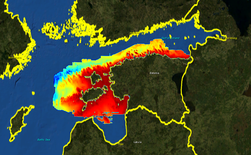
3085_Estonia_DTM
Composite DTM of the Estonian waters.
Simple
- Title
-
3085_Estonia_DTM
- Alternate title
-
Estonia_DTM
- Date (Creation)
- 2016-01-10T00:00:00
- Date (Revision)
- 2016-01-11T00:00:00
- Citation identifier
- Estonia_DTM
- Abstract
-
Composite DTM of the Estonian waters.
- Point of contact
-
Organisation name Individual name Electronic mail address Role Estonian Maritime Administration (Veeteede Amet)
Product manager Estonian Maritime Administration (Veeteede Amet)
Production center
-
Project name
-
-
EMODNet Bathymetry
-
-
Measuring devices
-
-
single-beam echosounders
-
multi-beam echosounders
-
-
Measuring devices
-
-
Differential Global Positioning System receivers
-
-
Parameter Discovery Vocabulary (P02)
-
-
Bathymetry and Elevation
-
-
GEMET - INSPIRE themes, version 1.0
-
-
Hydrography
-
- Access constraints
- License
- Use constraints
- Copyright
- Spatial representation type
- Grid
- Denominator
- 1000000
- Distance
- 50 Metres (m)
- Language
- English
- Character set
- UTF8
- Topic category
-
- Oceans
- Begin date
- 1945-01-01T00:00:00
- End date
- 2015-01-31T00:00:00
))
- Geographic identifier
- Baltic Sea
- Description
-
Map projection parameters, values and units :
Axes units :
- Geographic identifier
- EPSG / Estonian Coordinate System of 1997 EPSG:3301 / 7.4
- Reference system identifier
- EPSG / WGS84 EPSG:4326 / 7.4
- Number of dimensions
- 3
- Dimension name
- Column
- Dimension size
- 7440
- Dimension name
- Row
- Dimension size
- 2384
- Dimension name
- Time
- Dimension size
- 1
- Cell geometry
- Point
- Transformation parameter availability
- Checkpoint Availability
- Point in Pixel
-
- Center
- Distribution format
-
Name Version Ascii
1
- Distributor contact
-
Organisation name Individual name Electronic mail address Role Estonian Maritime Administration (Veeteede Amet)
Dissemination Unit
- Transfer size (in MB)
- 155
- OnLine resource
-
Protocol Linkage Name WWW:LINK
http://www.vta.ee
- Hierarchy level
- Dataset
Vertical extent
- Minimum value
- 0.1
- Maximum value
- 219.4
Vertical CRS
Vertical CS
Vertical datum
- Statement
-
no information
- Hierarchy level
- Feature
- Dataset
-
accuracy
Gridded data positional accuracy
- Name of measure
-
horizontal accuracy
- Measure identification
- horizontal accuracy of coordinate
Quantitative result
- Value type
- horizontal accuracy
- Value
- 100
Quantitative attribute accuracy
- Name of measure
-
depth
- Measure identification
- depth accuracy
Quantitative result
- Value
- not defined
Conformance result
- Title
-
Shoal bias
- Date
- Hierarchy level
- Software
- Other
-
software
- Hierarchy level
- Property type
- Description
-
parameters of data processing
Attributes
- Statement
-
Description of data processing : n/a
- Description
-
Description of processed data sources : n/a
- Hierarchy level
- Dataset
- Horizontal Quality Indicator
- -1 - Multisources
- Vertical Quality Indicator
- -1 - Multisources
- Purpose Quality Indicator
- 3 - Hydrographic survey or compatible with hydrographic standards
Metadata
- File identifier
- SDN_CPRD_3085_Estonia_DTM
- Metadata language
- English
- Character set
- UTF8
- Hierarchy level name
-
Composite Product Record
- Date stamp
- 2018-03-15T10:43:18
- Metadata standard name
-
ISO 19115:2003/19139 - EMODNET - BATHYMETRY
- Metadata standard version
-
1.0
- Metadata author
-
Organisation name Individual name Electronic mail address Role Federal Maritime and Hydrographic Agency
Author
accessData
Overviews
)))