353_291007-Balear Islands Margin
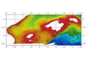
Composite DTM of the Baleares Islands margin, (Mediterranean Sea, East Spain).
Simple
- Title
-
353_291007-Balear Islands Margin
- Alternate title
-
291007
- Date (Creation)
- 2009-11-01T12:00:00
- Date (Revision)
- 2010-04-30T12:00:00
- Citation identifier
- 291007
- Abstract
-
Composite DTM of the Baleares Islands margin, (Mediterranean Sea, East Spain).
- Point of contact
-
Organisation name Individual name Electronic mail address Role Istituto Espanol de Oceanografia (IEO)
Product manager Istituto Espanol de Oceanografia (IEO)
Production center
-
Thèmes Sextant
-
-
/Physical Environment/Bathymetry/Digital Terrain Model
-
-
Project name
-
-
EMODNet Hydrography
-
-
SeaDataNet device categories
-
-
single-beam echosounders
-
multi-beam echosounders
-
-
SeaDataNet device categories
-
-
Differential Global Positioning System receivers
-
-
Parameter Discovery Vocabulary (P02)
-
-
Bathymetry and Elevation
-
-
GEMET - INSPIRE themes, version 1.0
-
-
Hydrography
-
- Access constraints
- Restricted
- Use constraints
- Copyright
- Other legal constraints
-
Contact josel.sanz@md.ieo.es
- Use limitation
-
Not for navigation
- Spatial representation type
- Grid
- Denominator
- 200000
- Distance
- 0.0027 Degrees north (degree_north)
- Language
- English
- Character set
- UTF8
- Topic category
-
- Oceans
- Begin date
- 1983-03-01T12:00:00
- End date
- 2000-11-01T12:00:00
))
- Geographic identifier
- Balearic (Iberian) Sea (Mediterranean Sea)
- Reference system identifier
- EPSG / WGS 84 (EPSG:4326) / 7.4
- Number of dimensions
- 3
- Dimension name
- Column
- Dimension name
- Row
- Dimension name
- Time
- Dimension size
- 1
- Cell geometry
- Point
- Transformation parameter availability
- Checkpoint Availability
- Point in Pixel
-
- Center
- Distribution format
-
Name Version ESRI GRD
Not specified
- Distributor contact
-
Organisation name Individual name Electronic mail address Role Istituto Espanol de Oceanografia (IEO)
Dissemination Unit
- OnLine resource
-
Protocol Linkage Name WWW:LINK
http://www.ieo.es/ Web site of the Istituto Espanol de Oceanografia (IEO)
- Hierarchy level
- Dataset
Vertical extent
- Minimum value
- 0
- Maximum value
- 2939
Vertical CRS
Vertical CS
Vertical datum
- Statement
-
no information
- Hierarchy level
- Feature
- Dataset
-
accuracy
Gridded data positional accuracy
- Name of measure
-
horizontal accuracy
- Measure identification
- horizontal accuracy of coordinate
- Measure description
-
Not specified
- Evaluation method description
-
In all case, multiple tests have been made in order to use the method which would introduce less error in the result.
Quantitative result
- Value type
- horizontal accuracy
Quantitative attribute accuracy
- Name of measure
-
depth
- Measure identification
- depth accuracy
- Measure description
-
Not specified
- Evaluation method description
-
In all case, multiple tests have been made in order to use the method which would introduce less error in the result.
Quantitative result
- Value
- not defined
Conformance result
- Title
-
Shoal bias
- Date
- Pass
- Hierarchy level
- Software
- Description
-
ArcGIS
- Other
-
software
- Hierarchy level
- Property type
- Description
-
parameters of data processing
Attributes
- Statement
-
Description of data processing :
For elaborating this DTM we have used 8 data files obtained :
1. IHM and IEO MBES surveys of the EEZ of the margin of Baleares Islands. These data have been processed, filtered, and finally gridded for the data owner with a resolution of 100 x 100 meters . Using this DTM, a DTM with 250 meters of resolution has been produced using IDW methods.
2. The IEO got this information in vectorial format as isobaths with different equidistance, according to depth, from 10 meters to 200 meters, and two DTM with 50x50 meters of resolution, according to depth. From this isobaths and using the TOPOGRID (command for interpolation a MDT from isobaths) a second DTM was made with 250meters of resolution. Later this DTM was transformed to Geographic Coordinates with the PROJECT command of ArcGis software, with a resolution of 0,0027 decimal degrees . Finally a single DTM for this zone was created with the MOSAIC command of ArcGis, in this case never these grids are intersecting between them; the grids are adjacent with a small zone of intersection to avoid the appearance of holes.
- Description
-
Description of processed data sources :
The data sources of this DTM have been the data obtained from different surveys: BALCOM, ZEEE, GEOCARBAL, and others realized by the Coastal General Directions (MOPU). The instruments used have been multibeam echosonder, and single beam echosonder.
- Hierarchy level
- Dataset
- Horizontal Quality Indicator
- 1 - Between 500m and 50m
- Vertical Quality Indicator
- 1 - SBES low frequency, SDB (similar than 2+5%d)
- Purpose Quality Indicator
- 2 - Bathymetric/morphologic survey
Metadata
- File identifier
- SDN_CPRD_353_291007
- Metadata language
- English
- Character set
- UTF8
- Hierarchy level name
-
Composite Product Record
- Date stamp
- 2020-06-04T00:23:31
- Metadata standard name
-
ISO 19115:2003/19139 - EMODNET - BATHYMETRY
- Metadata standard version
-
1.0
- Metadata author
-
Organisation name Individual name Electronic mail address Role Istituto Espanol de Oceanografia (IEO)
Author
accessData
Overviews
)))