353_291102-ECOMARG
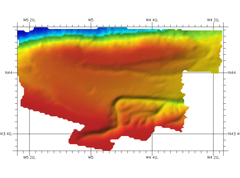
DTM of the northern cantabric margin, approximately 200 m. resolution. This DTM includes a band from 30 kilometres of the coast.
Simple
- Title
-
353_291102-ECOMARG
- Alternate title
-
291102
- Date (Creation)
- 2011-03-16T12:00:00
- Date (Revision)
- 2012-03-30T12:00:00
- Citation identifier
- 291102
- Abstract
-
DTM of the northern cantabric margin, approximately 200 m. resolution. This DTM includes a band from 30 kilometres of the coast.
- Point of contact
-
Organisation name Individual name Electronic mail address Role Istituto Espanol de Oceanografia (IEO)
Product manager Istituto Espanol de Oceanografia (IEO)
Production center
-
Thèmes Sextant
-
-
/Physical Environment/Bathymetry/Digital Terrain Model
-
-
Project name
-
-
EMODNet Seabed Mapping
-
-
SeaDataNet device categories
-
-
multi-beam echosounders
-
-
SeaDataNet device categories
-
-
Differential Global Positioning System receivers
-
-
Parameter Discovery Vocabulary (P02)
-
-
Bathymetry and Elevation
-
-
GEMET - INSPIRE themes, version 1.0
-
-
Hydrography
-
- Access constraints
- Restricted
- Use constraints
- Copyright
- Other legal constraints
-
Contact ideo@ieo.es
- Use limitation
-
Not for navigationContact ideo@ieo.es
- Spatial representation type
- Grid
- Denominator
- 200000
- Distance
- 0.002 Degrees north (degree_north)
- Language
- English
- Character set
- UTF8
- Topic category
-
- Oceans
- Begin date
- 2003-01-01T12:00:00
- End date
- 2004-12-31T12:00:00
))
- Geographic identifier
- Bay of Biscay
- Reference system identifier
- EPSG / WGS 84 (EPSG:4326) / 7.4
- Number of dimensions
- 3
- Dimension name
- Column
- Dimension name
- Row
- Dimension name
- Time
- Dimension size
- 1
- Cell geometry
- Point
- Transformation parameter availability
- Checkpoint Availability
- Point in Pixel
-
- Center
- Distribution format
-
Name Version ESRI GRID
Not specified
- Distributor contact
-
Organisation name Individual name Electronic mail address Role Istituto Espanol de Oceanografia (IEO)
Dissemination Unit
- OnLine resource
-
Protocol Linkage Name WWW:LINK
http://www.ieo.es/ Web site of the Istituto Espanol de Oceanografia (IEO)
- Hierarchy level
- Dataset
Vertical extent
- Minimum value
- 128
- Maximum value
- 4609
Vertical CRS
Vertical CS
Vertical datum
- Statement
-
no information
- Hierarchy level
- Feature
- Dataset
-
accuracy
Gridded data positional accuracy
- Name of measure
-
horizontal accuracy
- Measure identification
- horizontal accuracy of coordinate
- Evaluation method description
-
In all the cases, the owner of the information has made the quality controls for every zone.
Quantitative result
- Value type
- horizontal accuracy
Quantitative attribute accuracy
- Name of measure
-
depth
- Measure identification
- depth accuracy
- Evaluation method description
-
In all the cases, the owner of the information has made the quality controls for every zone.
Quantitative result
- Value
- not defined
Conformance result
- Title
-
Shoal bias
- Date
- Pass
- Hierarchy level
- Software
- Description
-
ARC GIS
- Other
-
software
- Hierarchy level
- Property type
- Description
-
parameters of data processing
Attributes
- Statement
-
Description of data processing :
The DTM made available has been extracted from the 100mx100m GRID (Argis raster format) using the RESAMPLE method of interpolation to make the DTM in angular coordinates at a resolution of 1/8 arc-minute of latitude and longitude.
- Description
-
Description of processed data sources :
Data sources were collected by IEO coordinated by Sea General Secretary (Ministerio de Medio Ambiente Rural y Marino de España). The measuring instruments were GPSD Seastart and Seapath-204 for positioning and MBES SIMRAD EM-300 for echosounding. Data have been supplied as ASCII GRID files processed with ARCGIS.
at a resolution of 100 m x 100 m.
- Hierarchy level
- Dataset
- Horizontal Quality Indicator
- 1 - Between 500m and 50m
- Vertical Quality Indicator
- 2 - MBES low frequency (lower than 100kHz) (similar than 1+2%d)
- Purpose Quality Indicator
- 2 - Bathymetric/morphologic survey
Metadata
- File identifier
- SDN_CPRD_353_291102
- Metadata language
- English
- Character set
- UTF8
- Hierarchy level name
-
Composite Product Record
- Date stamp
- 2018-01-29T16:43:06
- Metadata standard name
-
ISO 19115:2003/19139 - EMODNET - BATHYMETRY
- Metadata standard version
-
1.0
- Metadata author
-
Organisation name Individual name Electronic mail address Role Istituto Espanol de Oceanografia (IEO)
Author
accessData
Overviews
)))