353_291104 - PAIS_VASCO
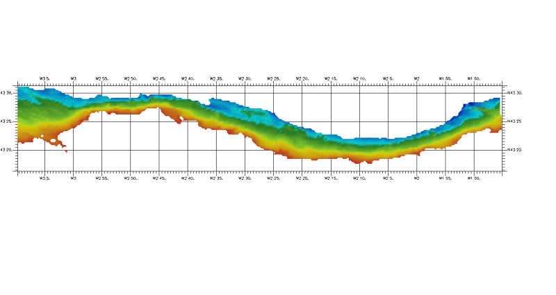
DTM of coast of Biscay and Guipuzcoa , approximately 250 m resolution. This DTM includes the whole area from coast line to deepest level (144,058 m)
Simple
- Title
-
353_291104 - PAIS_VASCO
- Alternate title
-
291104
- Date (Creation)
- 2011-03-17T12:00:00
- Date (Revision)
- 2011-03-30T12:00:00
- Citation identifier
- 291104
- Abstract
-
DTM of coast of Biscay and Guipuzcoa , approximately 250 m resolution. This DTM includes the whole area from coast line to deepest level (144,058 m)
- Point of contact
-
Organisation name Individual name Electronic mail address Role Istituto Espanol de Oceanografia (IEO)
Product manager Istituto Espanol de Oceanografia (IEO)
Production center
-
Thèmes Sextant
-
-
/Physical Environment/Bathymetry/Digital Terrain Model
-
-
Project name
-
-
EMODNet Seabed Mapping
-
-
SeaDataNet device categories
-
-
multi-beam echosounders
-
-
SeaDataNet device categories
-
-
Differential Global Positioning System receivers
-
-
Parameter Discovery Vocabulary (P02)
-
-
Bathymetry and Elevation
-
-
GEMET - INSPIRE themes, version 1.0
-
-
Hydrography
-
- Access constraints
- Restricted
- Use constraints
- Copyright
- Other legal constraints
-
Contact ideo@ieo.es
- Use limitation
-
Not for navigation.Contact ideo@ieo.es
- Spatial representation type
- Grid
- Denominator
- 200000
- Distance
- 0.002 Degrees north (degree_north)
- Language
- English
- Character set
- UTF8
- Topic category
-
- Oceans
- Begin date
- 2005-01-01T12:00:00
- End date
- 2009-12-31T12:00:00
))
- Geographic identifier
- Bay of Biscay
- Reference system identifier
- EPSG / WGS 84 (EPSG:4326) / 7.4
- Number of dimensions
- 3
- Dimension name
- Column
- Dimension name
- Row
- Dimension name
- Time
- Dimension size
- 1
- Cell geometry
- Point
- Transformation parameter availability
- Checkpoint Availability
- Point in Pixel
-
- Center
- Distribution format
-
Name Version ESRI GRID
not speciifed
- Distributor contact
-
Organisation name Individual name Electronic mail address Role Istituto Espanol de Oceanografia (IEO)
Dissemination Unit
- OnLine resource
-
Protocol Linkage Name WWW:LINK
http://www.ieo.es/ Web site of the Istituto Espanol de Oceanografia (IEO)
- Hierarchy level
- Dataset
Vertical extent
- Minimum value
- 4
- Maximum value
- 115
Vertical CRS
Vertical CS
Vertical datum
- Statement
-
no information
- Hierarchy level
- Feature
- Dataset
-
accuracy
Gridded data positional accuracy
- Name of measure
-
horizontal accuracy
- Measure identification
- horizontal accuracy of coordinate
- Evaluation method description
-
In all the cases, the owner of the information has made the quality controls for every zone
Quantitative result
- Value type
- horizontal accuracy
Quantitative attribute accuracy
- Name of measure
-
depth
- Measure identification
- depth accuracy
- Evaluation method description
-
In all the cases, the owner of the information has made the quality controls for every zone
Quantitative result
- Value
- not defined
Conformance result
- Title
-
Shoal bias
- Date
- Pass
- Hierarchy level
- Software
- Description
-
ArcGIS
- Other
-
software
- Hierarchy level
- Property type
- Description
-
parameters of data processing
Attributes
- Statement
-
Description of data processing :
The DTM has been extracted from the AZTI GRID (Argis raster format) using the RESAMPLE method of interpolation to convert it to angular coordinates at a resolution of 1/8 arc-minute of latitude and longitude.
- Description
-
Description of processed data sources :
The DTM is derived from RESON SEABAT 8125 and RESON SEABAT 7125 multibeam echosounder surveys using Trimble agp132 GPSD for positioning. The source data have been obtained from AZTI as ASCII ArcGIS GRID files at a resolution of 250 m x 250 m.
- Hierarchy level
- Dataset
- Horizontal Quality Indicator
- 2 - Between 50 m and 20 m
- Vertical Quality Indicator
- 2 - MBES low frequency (lower than 100kHz) (similar than 1+2%d)
- Purpose Quality Indicator
- 2 - Bathymetric/morphologic survey
Metadata
- File identifier
- SDN_CPRD_353_291104
- Metadata language
- English
- Character set
- UTF8
- Hierarchy level name
-
Composite Product Record
- Date stamp
- 2018-01-29T16:44:02
- Metadata standard name
-
ISO 19115:2003/19139 - EMODNET - BATHYMETRY
- Metadata standard version
-
1.0
- Metadata author
-
Organisation name Individual name Electronic mail address Role Istituto Espanol de Oceanografia (IEO)
Author
accessData
Overviews
)))