353_291105 - Cantabric Sea
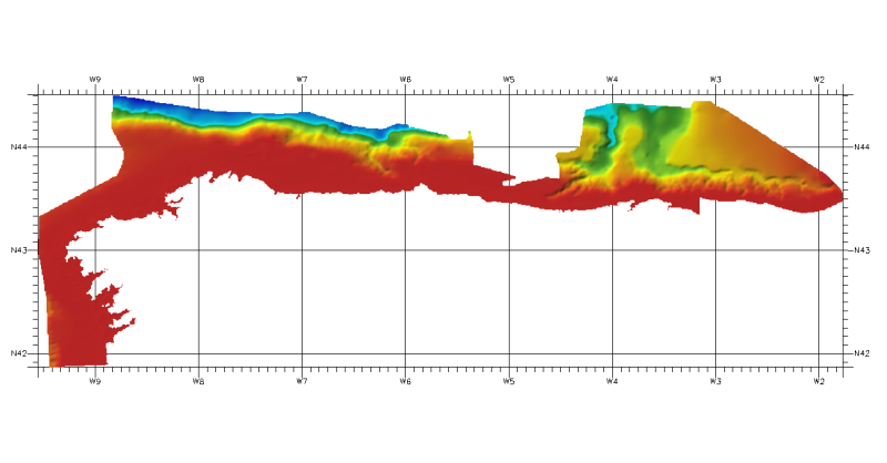
DTM of continental margin of Cantabric Sea, approximately 200 m resolution. This DTM includes the whole area from coast line to deepest level (5216,74 m).
Simple
- Title
-
353_291105 - Cantabric Sea
- Alternate title
-
291105
- Date (Creation)
- 2011-04-08T15:00:00
- Date (Revision)
- 2016-05-24T11:40:00
- Citation identifier
- 291105
- Abstract
-
DTM of continental margin of Cantabric Sea, approximately 200 m resolution. This DTM includes the whole area from coast line to deepest level (5216,74 m).
- Point of contact
-
Organisation name Individual name Electronic mail address Role Instituto Espanol de Oceanografia (IEO)
Product manager Instituto Espanol de Oceanografia (IEO)
Production center
-
Thèmes Sextant
-
-
/Physical Environment/Bathymetry/Digital Terrain Model
-
-
Project name
-
-
EMODNet Seabed Mapping
-
-
Measuring devices
-
-
single-beam echosounders
-
multi-beam echosounders
-
-
Measuring devices
-
-
Differential Global Positioning System receivers
-
-
Parameter Discovery Vocabulary (P02)
-
-
Bathymetry and Elevation
-
-
GEMET - INSPIRE themes, version 1.0
-
-
Hydrography
-
- Access constraints
- Restricted
- Use constraints
- Copyright
- Other legal constraints
-
Contact ideo@ieo.es
- Use limitation
-
Not for navigation
- Spatial representation type
- Grid
- Denominator
- 200000
- Language
- English
- Character set
- UTF8
- Topic category
-
- Oceans
- Begin date
- 1974-01-01T12:00:00
- End date
- 2010-01-02T12:00:00
))
- Geographic identifier
- Bay of Biscay
- Reference system identifier
- EPSG / WGS 84 (EPSG:4326) / 7.4
- Number of dimensions
- 3
- Dimension name
- Column
- Dimension size
- 1966
- Dimension name
- Row
- Dimension size
- 633
- Dimension name
- Time
- Dimension size
- 1
- Cell geometry
- Point
- Transformation parameter availability
- Checkpoint Availability
- Point in Pixel
-
- Center
- Distribution format
-
Name Version ESRI Grd
10.2
- Distributor contact
-
Organisation name Individual name Electronic mail address Role Instituto Espanol de Oceanografia (IEO)
Dissemination Unit
- OnLine resource
-
Protocol Linkage Name WWW:LINK
http://www.ieo.es/ Web site of the Instituto Espanol de Oceanografia (IEO)
- Hierarchy level
- Dataset
Vertical extent
- Minimum value
- 0
- Maximum value
- 5216
Vertical CRS
Vertical CS
Vertical datum
- Statement
-
no information
- Hierarchy level
- Feature
- Dataset
-
accuracy
Gridded data positional accuracy
- Name of measure
-
horizontal accuracy
- Measure identification
- horizontal accuracy of coordinate
- Measure description
-
Not specified
Quantitative attribute accuracy
- Name of measure
-
depth
- Measure identification
- depth accuracy
- Measure description
-
Not specified
Quantitative result
- Value
- not defined
Conformance result
- Title
-
Shoal bias
- Date
- Pass
- Hierarchy level
- Software
- Description
-
ARcGIS
- Other
-
software
- Hierarchy level
- Property type
- Description
-
parameters of data processing
Attributes
- Statement
-
Description of data processing :
The information was processed with ARCGIS software to create a DTM at a resolution of 200 m x 200 m. approximately. The IEO got this information in vectorial format as isobaths with different equidistance, from coast line or 0 meters to 5216,74 meters, according to depth. From this isobaths using the TOPOGRID (command for interpolation a DTM from isobaths) we made a DTM in angular coordinates at a resolution of 1/8 arc-minute of latitude and longitude.
- Description
-
Description of processed data sources :
Depth data have been obtained as isobaths from several sources.
Metadata
- File identifier
- SDN_CPRD_353_291105
- Metadata language
- English
- Character set
- UTF8
- Hierarchy level name
-
Composite Product Record
- Date stamp
- 2018-01-18T13:09:25
- Metadata standard name
-
ISO 19115:2003/19139 - EMODNET - BATHYMETRY
- Metadata standard version
-
1.0
- Metadata author
-
Organisation name Individual name Electronic mail address Role Instituto Espanol de Oceanografia (IEO)
Author
accessData
Overviews
)))