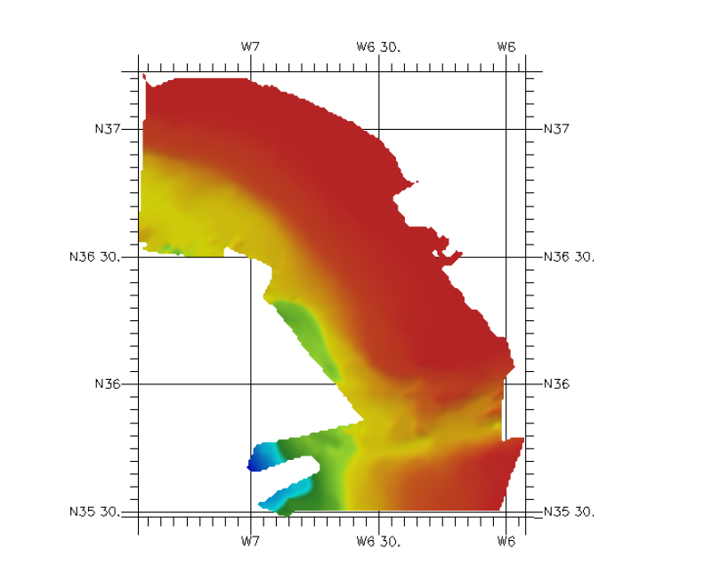
353_291106- Gulf of Cádiz
Cantabric margin of Bay of Biscay with a resolution of approximately 200 m
Simple
- Title
-
353_291106- Gulf of Cádiz
- Alternate title
-
291106
- Date (Creation)
- 2011-04-14T12:00:00
- Date (Revision)
- 2011-04-14T12:00:00
- Citation identifier
- 291106
- Abstract
-
Cantabric margin of Bay of Biscay with a resolution of approximately 200 m
- Point of contact
-
Organisation name Individual name Electronic mail address Role IEO/Spanish Oceanographic Institute
Production center IEO/Spanish Oceanographic Institute
Product manager
-
Thèmes Sextant
-
-
/Physical Environment/Bathymetry/Digital Terrain Model
-
-
Project name
-
-
EMODNet Hydrography
-
-
SeaDataNet device categories
-
-
single-beam echosounders
-
multi-beam echosounders
-
-
Parameter Discovery Vocabulary (P02)
-
-
Bathymetry and Elevation
-
-
GEMET - INSPIRE themes, version 1.0
-
-
Hydrography
-
- Access constraints
- Restricted
- Use constraints
- Copyright
- Other legal constraints
-
Contact ideo@ieo.es
- Use limitation
-
not for navigation
- Spatial representation type
- Grid
- Denominator
- 1000000
- Distance
- 0.002 Degrees north (degree_north)
- Language
- English
- Character set
- UTF8
- Topic category
-
- Oceans
- Begin date
- 1974-01-01T12:00:00
- End date
- 2008-12-31T12:00:00
))
- Geographic identifier
- Bay of Biscay
- Reference system identifier
- EPSG / WGS 84 (EPSG:4326) / 7.4
- Number of dimensions
- 3
- Dimension name
- Column
- Dimension name
- Row
- Dimension name
- Time
- Dimension size
- 1
- Cell geometry
- Point
- Transformation parameter availability
- Checkpoint Availability
- Point in Pixel
-
- Center
- Distribution format
-
Name Version ESRI GRD
not specified
- Distributor contact
-
Organisation name Individual name Electronic mail address Role IEO/Spanish Oceanographic Institute
Dissemination Unit
- OnLine resource
-
Protocol Linkage Name WWW:LINK
http://www.ieo.es/ Web site of the Istituto Espanol de Oceanografia (IEO)
- Hierarchy level
- Dataset
Vertical extent
- Minimum value
- 0
- Maximum value
- 5216
Vertical CRS
Vertical CS
Vertical datum
- Statement
-
no information
- Hierarchy level
- Feature
- Dataset
-
accuracy
Gridded data positional accuracy
- Name of measure
-
horizontal accuracy
- Measure identification
- horizontal accuracy of coordinate
Quantitative result
- Value type
- horizontal accuracy
Quantitative attribute accuracy
- Name of measure
-
depth
- Measure identification
- depth accuracy
Quantitative result
- Value
- not defined
Conformance result
- Title
-
Shoal bias
- Date
- Pass
- Hierarchy level
- Software
- Other
-
software
- Hierarchy level
- Property type
- Description
-
parameters of data processing
Attributes
- Statement
-
Description of data processing :
Not specified
- Description
-
Description of processed data sources :
Not specified
- Hierarchy level
- Dataset
- Horizontal Quality Indicator
- 3 - < 20 m
- Vertical Quality Indicator
- 4 - MBES High frequency (higher that 100kHz) (1+0.5%d)
- Purpose Quality Indicator
- 2 - Bathymetric/morphologic survey
Metadata
- File identifier
- SDN_CPRD_353_291106
- Metadata language
- English
- Character set
- UTF8
- Hierarchy level name
-
Composite Product Record
- Date stamp
- 2018-07-02T13:47:46
- Metadata standard name
-
ISO 19115:2003/19139 - EMODNET - BATHYMETRY
- Metadata standard version
-
1.0
- Metadata author
-
Organisation name Individual name Electronic mail address Role IEO/Spanish Oceanographic Institute
Author
accessData
Overviews
)))