353_291222-ESPACE-MEDIT-CONTINENTAL-SHELF
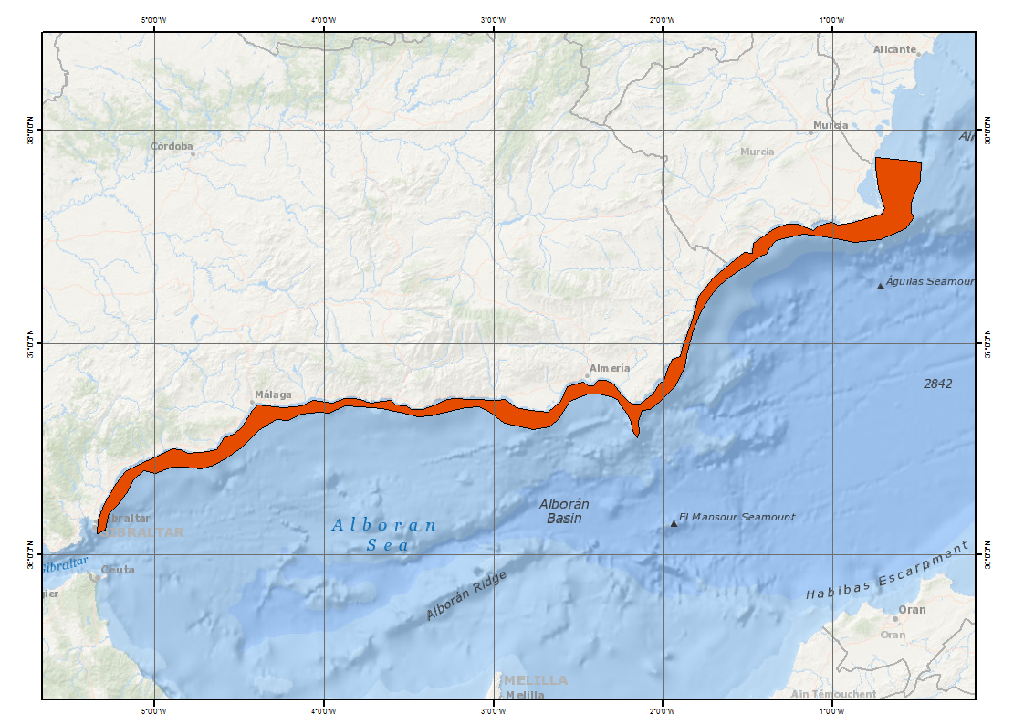
Composite DTM of Mediterranean Continental Shelf at approximately 225m of resolution
Simple
- Title
-
353_291222-ESPACE-MEDIT-CONTINENTAL-SHELF
- Alternate title
-
291222
- Date (Creation)
- 2014-05-01T00:00:00
- Date (Revision)
- 2010-05-01T17:00:00
- Citation identifier
- 291222
- Abstract
-
Composite DTM of Mediterranean Continental Shelf at approximately 225m of resolution
- Point of contact
-
Organisation name Individual name Electronic mail address Role Instituto Espanol de Oceanografia (IEO)
Product manager Instituto Espanol de Oceanografia (IEO)
Production center
-
Thèmes Sextant
-
-
/Physical Environment/Bathymetry/Digital Terrain Model
-
-
Project name
-
-
EMODNet Hydrography
-
-
Measuring devices
-
-
multi-beam echosounders
-
-
Measuring devices
-
-
Differential Global Positioning System receivers
-
-
Parameter Discovery Vocabulary (P02)
-
-
Bathymetry and Elevation
-
-
GEMET - INSPIRE themes, version 1.0
-
-
Hydrography
-
- Access constraints
- Restricted
- Use constraints
- Copyright
- Other legal constraints
-
Contact olvido.tello@md.ieo.es
- Use limitation
-
Not for navigation
- Spatial representation type
- Grid
- Denominator
- 200000
- Distance
- 225 Metres (m)
- Language
- English
- Character set
- UTF8
- Topic category
-
- Oceans
- Begin date
- 2000-01-01T00:00:00
- End date
- 2003-12-31T00:00:00
))
- Geographic identifier
- Alboran Sea (Mediterranean Sea)
- Reference system identifier
- EPSG / WGS 84 (EPSG:4326) / 7.4
- Number of dimensions
- 3
- Dimension name
- Column
- Dimension size
- 8925
- Dimension name
- Row
- Dimension size
- 3521
- Dimension name
- Time
- Dimension size
- 1
- Cell geometry
- Point
- Transformation parameter availability
- Checkpoint Availability
- Point in Pixel
-
- Center
- Distribution format
-
Name Version ESRI GRD
unknown
- Distributor contact
-
Organisation name Individual name Electronic mail address Role Instituto Espanol de Oceanografia (IEO)
Dissemination Unit
- Hierarchy level
- Dataset
Vertical extent
- Minimum value
- 3.35
- Maximum value
- 165
Vertical CRS
Vertical CS
Vertical datum
- Statement
-
no information
- Hierarchy level
- Feature
- Dataset
-
accuracy
Gridded data positional accuracy
- Name of measure
-
horizontal accuracy
- Measure identification
- horizontal accuracy of coordinate
- Measure description
-
In all case, multiple tests have been made in order to use the method which would introduce less error in the result
- Evaluation method description
-
In all case, multiple tests have been made in order to use the method which would introduce less error in the result
Quantitative attribute accuracy
- Name of measure
-
depth
- Measure identification
- depth accuracy
- Evaluation method description
-
In all case, multiple tests have been made in order to use the method which would introduce less error in the result
Quantitative result
- Value
- not defined
Conformance result
- Title
-
Shoal bias
- Date
- Pass
- Hierarchy level
- Software
- Description
-
ArcGis IDW
- Other
-
software
- Hierarchy level
- Property type
- Description
-
parameters of data processing
Attributes
- Statement
-
Description of data processing :
No harmonisation of vertical datum have been applied when merging data sources (compatibility with Sea Level in a few tens of cm near)).
Source data received from data owners were DTM in GRID format (raster format ArcGis, structured in a matrix regular bathymetry associated with the centre of the cell of two types of format (raster format of ArcGis) with different resolutions. From each grid, we obtained a point SHAPE file, each point corresponds to the centre of the cell on the grid. Each point has the depth value of each cell. With each point SHAPE file, we use de command IDW (ArcGis) to realize an IDW Interpolation, (assigning weight in function of inverse of the distance). We have worked with the number of points that produced less error, in each case.When the DTM is composed by several grids with MOSAIC command of ArcGis, never these grids are intersecting between them; the grids are adjacent with a small zone of intersection to avoid the appearance of holes.
- Description
-
Description of processed data sources :
This DTM has been elaborated from several grids (ArcGis raster format), both treated with the IDW method.
These are a grid of 25 x 25 meters of resolution derived from a MBES SIMRAD 1000 survey with information about continental shelf and slope. The depths are between 5 and 160 meters.
The vertical datum is the zero of the patron port of Malaga (in Alboran W).
This information has been obtained in the ESPACE project. Spanish Institute of Oceanography.
Metadata
- File identifier
- SDN_CPRD_353_291222
- Metadata language
- English
- Character set
- UTF8
- Hierarchy level name
-
Composite Product Record
- Date stamp
- 2020-06-04T00:31:04
- Metadata standard name
-
ISO 19115:2003/19139 - EMODNET - BATHYMETRY
- Metadata standard version
-
1.0
- Metadata author
-
Organisation name Individual name Electronic mail address Role Istituto Espanol de Oceanografia (IEO)
Author
accessData
Overviews
)))