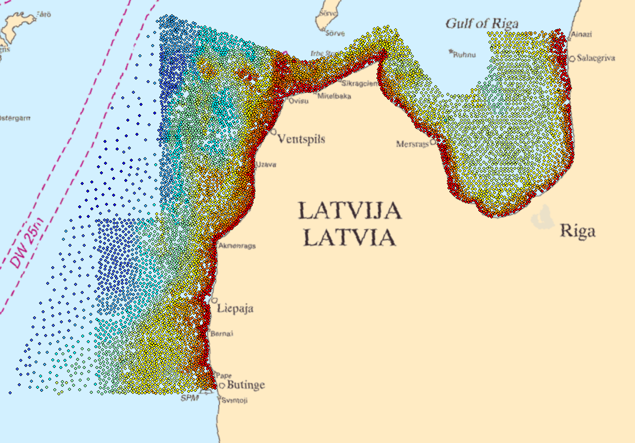
Latvian waters, charted soundings
Data extracted from older sea charts. The sea charts used for this is based on older Russian surveys in areas that has not yet been surveyed to present standard.
Simple
- Title
-
Latvian waters, charted soundings
- Alternate title
-
EMODNET-IFR-WESTMED-2012
- Date (Creation)
- 2018-01-10
- Date (Revision)
- 2018-01-10
- Citation identifier
- LATCHART
- Abstract
-
Data extracted from older sea charts. The sea charts used for this is based on older Russian surveys in areas that has not yet been surveyed to present standard.
- Point of contact
-
Organisation name Individual name Electronic mail address Role Maritime Administration of Latvia (MAL)
Production center Maritime Administration of Latvia (MAL)
Product manager
-
Project name
-
-
EMODnet HRSM
-
-
SeaDataNet device categories
-
-
multi-beam echosounders
-
plummets
-
single-beam echosounders
-
-
Parameter Discovery Vocabulary (P02)
-
-
Bathymetry and Elevation
-
-
GEMET - INSPIRE themes, version 1.0
-
-
Hydrography
-
- Use limitation
-
Data are not to be:
*used for safety of navigation purposes
*used in Electronic Chart Display Systems
*used as an aid to navigaton
- Access constraints
- License
- Use constraints
- Copyright
- Other legal constraints
-
Data are not to be:
*used for safety of navigation purposes
*used in Electronic Chart Display Systems
*used as an aid to navigaton
- Use limitation
-
Data originates from the Latvian Hydrographic Office.
- Spatial representation type
- Vector
- Denominator
- 50000
- Distance
- 300 Metres (m)
- Language
- English
- Character set
- UTF8
- Topic category
-
- Oceans
- Begin date
- 1900-01-01
- End date
- 1994-12-31 Before
))
- Description
-
Map projection parameters, values and units :
Axes units :
- Codespace
-
EPSG
- Version
-
7.4
- Reference system identifier
- EPSG / WGS-84 (EPSG:4326) / Elevations are stored in Baltic Sea Chart Datum 2000 (MSL)
- Number of dimensions
- 3
- Dimension name
- Column
- Dimension name
- Row
- Dimension name
- Time
- Dimension size
- 1
- Cell geometry
- Point
- Transformation parameter availability
- Checkpoint Availability
- Point in Pixel
-
- Center
- Distribution format
-
Name Version XYZ Ascii
- Distributor contact
-
Organisation name Individual name Electronic mail address Role Maritime Administration of Latvia (MAL)
Dissemination Unit
- Transfer size (in MB)
- 2
- Hierarchy level
- Dataset
Vertical extent
- Minimum value
- 0
- Maximum value
- 240
Vertical CRS
Vertical CS
Vertical datum
- Statement
-
no information
- Hierarchy level
- Feature
- Dataset
-
accuracy
Gridded data positional accuracy
- Name of measure
-
horizontal accuracy
- Measure identification
- horizontal accuracy of coordinate
- Measure description
-
Varying positioning methods has been used and hence it is impossible to set one value of the accuracy. It can vary from <1m to 50m.
- Evaluation method description
-
No validation done.
Quantitative result
- Value type
- horizontal accuracy
- Value
- 50m
Quantitative attribute accuracy
- Name of measure
-
depth
- Measure identification
- depth accuracy
- Measure description
-
Varying survey methods has been used over the years and hence it is impossible to set one value of the accuracy.
- Evaluation method description
-
No validation done
Quantitative result
- Value
- not defined
Conformance result
- Title
-
Shoal bias
- Date
- Explanation
-
Yes for nautical chart production.
- Pass
- Hierarchy level
- Software
- Other
-
software
- Hierarchy level
- Property type
- Description
-
parameters of data processing
Attributes
- Statement
-
No interpolation of data.
- Description
-
This is an extract of the available data from the Latvian territorial Waters.
- Hierarchy level
- Dataset
- Horizontal Quality Indicator
- 1 - Between 500m and 50m
- Vertical Quality Indicator
- -1 - Multisources
- Purpose Quality Indicator
- 3 - Hydrographic survey or compatible with hydrographic standards
Metadata
- File identifier
- SDN_CPRD_4665_LATCHART
- Metadata language
- English
- Character set
- UTF8
- Hierarchy level name
-
Product record
- Date stamp
- 2020-01-14T16:32:00
- Metadata standard name
-
ISO 19115:2003/19139 - EMODNET - BATHYMETRY
- Metadata standard version
-
1.0
- Metadata author
-
Organisation name Individual name Electronic mail address Role Swedish Maritime Administration
Author
accessData
Overviews
)))