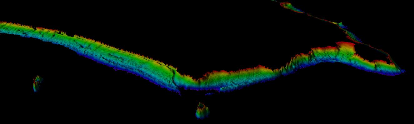
Satellite Derived Bathymetry South Aegean, Karpathos, Rhodos & Cos - Greece
Data provides bathymetric information based on Landsat 8 satellite at 15 m resolution.
Data were processed by the Modular and Inversion System (MIP) by EOMAP GmbH Co.KG. MIP is designed for the physically based assessment of hydro-biological parameters from multi- and hyperspectral remote sensing data.
Supplemental_Information:
EOMAPs Satellite Derived Bathymetry (SDB) method relies on the reflected light energy which is measured at the satellite sensor in space. In order to measure the water column thickness, the sea bottom reflection must be separated from all other simultaneously measured portions of light. Other contributors of light scattered to the sensor are atmospheric molecules and aerosols, adjacent scattering from land, the water surface reflection, and light scattered and absorbed due to particular properties of water constituents and the pure water itself. The pure water itself also absorbs light in a spectrally specific manner and therefore leaves unique signatures in the signal while the light passes through the water column and returns after reflection at the sea bottom. This property is relevant to estimate water depth from optical satellite imagery. As many properties can vary over space and time, effective correction, regularization and retrieval algorithms must be applied to avoid instable results. EOMAP developed and maintains these unique algorithm and its workflows for almost 2 decades. The maximum depth the system is able to sense is related to the complex interaction of radiance of bottom material, incident sun angle and intensity, and the type and quantity of organics or sediments in the water column. As a rule-of-thumb, satellite derived bathymetry should be capable of sensing bottom to depths equal to one to one point five times the Secchi depth.
no-data-value optically deep water: -9999
Simple
- Title
-
Satellite Derived Bathymetry South Aegean, Karpathos, Rhodos & Cos - Greece
- Date (Creation)
- 2017-11-21
- Citation identifier
- greece1007
- Abstract
-
Data provides bathymetric information based on Landsat 8 satellite at 15 m resolution.
Data were processed by the Modular and Inversion System (MIP) by EOMAP GmbH Co.KG. MIP is designed for the physically based assessment of hydro-biological parameters from multi- and hyperspectral remote sensing data.
Supplemental_Information:
EOMAPs Satellite Derived Bathymetry (SDB) method relies on the reflected light energy which is measured at the satellite sensor in space. In order to measure the water column thickness, the sea bottom reflection must be separated from all other simultaneously measured portions of light. Other contributors of light scattered to the sensor are atmospheric molecules and aerosols, adjacent scattering from land, the water surface reflection, and light scattered and absorbed due to particular properties of water constituents and the pure water itself. The pure water itself also absorbs light in a spectrally specific manner and therefore leaves unique signatures in the signal while the light passes through the water column and returns after reflection at the sea bottom. This property is relevant to estimate water depth from optical satellite imagery. As many properties can vary over space and time, effective correction, regularization and retrieval algorithms must be applied to avoid instable results. EOMAP developed and maintains these unique algorithm and its workflows for almost 2 decades. The maximum depth the system is able to sense is related to the complex interaction of radiance of bottom material, incident sun angle and intensity, and the type and quantity of organics or sediments in the water column. As a rule-of-thumb, satellite derived bathymetry should be capable of sensing bottom to depths equal to one to one point five times the Secchi depth.
no-data-value optically deep water: -9999
- Point of contact
-
Organisation name Individual name Electronic mail address Role EOMAP GmbH & Co KG
Product manager EOMAP GmbH & Co KG
Production center
-
Parameter Discovery Vocabulary (P02)
-
-
Bathymetry and Elevation
-
-
SeaDataNet device categories
-
-
cameras
-
-
Vertical Datum
-
-
Lowest Astronomical Tide
-
-
Project name
-
-
EMODNet Bathymetry
-
-
Thèmes Sextant
-
-
/Physical Environment/Bathymetry/Digital Terrain Model
-
- Use limitation
-
see EOMAP EULA: EOMAP_Product_EULA2014Oct19.pdf
- Access constraints
- by negotiation
- Use constraints
- Copyright
- Use limitation
-
Reconnaissance survey, hydrodynamic modelling, pre-planning, coastal zone management
- Spatial representation type
- Grid
- Denominator
- 10000
- Distance
- 15 meter
- Language
- English
- Character set
- UTF8
- Topic category
-
- Oceans
- Begin date
- 2013-08-01
Vertical extent
- Minimum value
- 1
- Maximum value
- -20
Vertical CRS
- Description
-
South Aegean, Karpathos, Rhodos & Cos
))
- Reference system identifier
- EPSG / WGS 84 (EPSG:4326) / 8.6
- Reference system identifier
- EPSG / WGS 84 (EPSG:4326) / 7.4
- Number of dimensions
- 3
- Dimension name
- Column
- Dimension size
- 17157
- Dimension name
- Row
- Dimension size
- 14049
- Dimension name
- Time
- Dimension size
- 1
- Cell geometry
- Point
- Transformation parameter availability
- Checkpoint Availability
- Point in Pixel
-
- Lower left
- Distribution format
-
Name Version GeoTIFF
1.0
KML
XYZ Ascii
ESRI Shapefile
1.0
Distributor
- Transfer size (in MB)
- 20
- Hierarchy level
- Dataset
Conformance result
- Title
-
Shoal bias
- Date
- Explanation
-
No shoal bias
- Pass
Quantitative attribute accuracy
- Name of measure
-
depth
- Measure identification
- depth accuracy
- Measure description
-
General description of the vertical accuracies is given based on worldwide validation with acoustic and Lidar data and comparisons with nautical charts. For this area an on site validation was not possible because of the absence of modern surveyed data using acoustic or lidar technology.
- Evaluation method description
-
CE90
Quantitative result
- Value
- not defined
Gridded data positional accuracy
- Name of measure
-
horizontal accuracy
- Measure identification
- horizontal accuracy of coordinate
- Measure description
-
Based on global ground control points. Evaluation done by US Government.
- Evaluation method description
-
LE95
Quantitative result
- Value type
- horizontal accuracy
- Value
- 15m
- Horizontal Quality Indicator
- 3 - < 20 m
- Vertical Quality Indicator
- 1 - SBES low frequency, SDB (similar than 2+5%d)
- Purpose Quality Indicator
- 2 - Bathymetric/morphologic survey
- Hierarchy level
- Software
- Other
-
software
- Hierarchy level
- Property type
- Description
-
parameters of data processing
- Statement
-
Data were processed by the Modular and Inversion System (MIP) by EOMAP GmbH Co.KG.
MIP is designed for the physically based assessment of hydro-biological parameters from multi- and hyperspectral remote sensing data.
Correction modules applied:
Corrected for Satellite sensor noise: Yes
Corrected for atmospheric effects: Yes
Corrected for the effect of adjacent land reflectance: Yes
Corrected for effects of turbidity: Yes
Corrected for water refraction effect: No
Ground-control points accessed to improve horizontal accuracy: No
Local in-situ data accessed for calibration and validation purposes: No
Description of in-situ data used: None
Corrected for tidal influence: Yes (using predicted tidal station(s))
Metadata
- File identifier
- SDN_CPRD_4667_greece1007
- Metadata language
- English
- Character set
- UTF8
- Hierarchy level name
-
Composite Product Record
- Date stamp
- 2024-02-09T11:00:04.69Z
- Metadata standard name
-
ISO 19115:2003/19139 - EMODNET - BATHYMETRY
- Metadata standard version
-
1.0
- Metadata author
-
Organisation name Individual name Electronic mail address Role EOMAP GmbH & Co KG
Author
accessData
Overviews
)))