574_EMODNET REGIONAL DTM OF NETHERLANDS CONTINENTAL SHELF
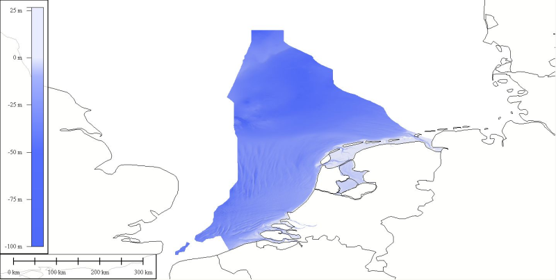
DTM compiled for inclusion into the EMODnet hydrography dataset. Original data was received from Netherlands Hydrographic Service at a source resolution of approximately 125 meters. An area north of the northern deep water routes on the Dutch continental shelf was not part of the source data. To fill in this area soundings taken from nautical charts were combined with the source data. The resulting data set was then interpolated using the ATLIS SENS software suite.
The source data is extracted from the RBB database of the Hydrographic office. The RBB holds data that is the actual reflection of water depth of the Dutch waters at a resolution higher than 125 meter. Please contact the hydrographic office for more details.
Simple
- Title
-
574_EMODNET REGIONAL DTM OF NETHERLANDS CONTINENTAL SHELF
- Alternate title
-
NETHERLANDS-DTM-1
- Date (Creation)
- 2012-02-13T12:00:00
- Date (Revision)
- 2012-02-13T12:00:00
- Citation identifier
- NETHERLANDS-DTM-1
- Abstract
-
DTM compiled for inclusion into the EMODnet hydrography dataset. Original data was received from Netherlands Hydrographic Service at a source resolution of approximately 125 meters. An area north of the northern deep water routes on the Dutch continental shelf was not part of the source data. To fill in this area soundings taken from nautical charts were combined with the source data. The resulting data set was then interpolated using the ATLIS SENS software suite.
The source data is extracted from the RBB database of the Hydrographic office. The RBB holds data that is the actual reflection of water depth of the Dutch waters at a resolution higher than 125 meter. Please contact the hydrographic office for more details.
- Point of contact
-
Organisation name Individual name Electronic mail address Role Royal Netherlands Navy Command, Hydrographic Office
Product manager Royal Netherlands Navy Command, Hydrographic Office
Production center
-
Thèmes Sextant
-
-
/Physical Environment/Bathymetry/Digital Terrain Model
-
-
Project name
-
-
EMODNet Hydrography
-
-
SeaDataNet device categories
-
-
single-beam echosounders
-
multi-beam echosounders
-
-
Parameter Discovery Vocabulary (P02)
-
-
Bathymetry and Elevation
-
-
GEMET - INSPIRE themes, version 1.0
-
-
Hydrography
-
- Use limitation
-
terms of delivery at www.hydro.nl
- Use constraints
- Copyright
- Other legal constraints
-
Terms of delivery at www.hydro.nl. Contact pom@hydro.nl
- Use limitation
-
terms of delivery at www.hydro.nl
- Spatial representation type
- Grid
- Denominator
- 500000
- Distance
- 0.00416667 Metres (m)
- Language
- English
- Character set
- UTF8
- Topic category
-
- Oceans
- Begin date
- 1967-04-16T12:00:00
- End date
- 2012-02-13T12:00:00
))
- Geographic identifier
- North Sea
- Reference system identifier
- EPSG / WGS 84 (EPSG:4326) / 7.4
- Number of dimensions
- 3
- Dimension name
- Column
- Dimension size
- 1335
- Dimension name
- Row
- Dimension size
- 1123
- Dimension name
- Time
- Dimension size
- 1
- Cell geometry
- Point
- Transformation parameter availability
- Checkpoint Availability
- Point in Pixel
-
- Center
- Distribution format
-
Name Version ASCII
1.0
- Distributor contact
-
Organisation name Individual name Electronic mail address Role Royal Netherlands Navy Command, Hydrographic Office
Dissemination Unit
- OnLine resource
-
Protocol Linkage Name WWW:LINK
http://www.hydro.nl
- Hierarchy level
- Dataset
Vertical extent
- Minimum value
- -26.6
- Maximum value
- 63.0
Vertical CRS
Vertical CS
Vertical datum
- Statement
-
no information
- Hierarchy level
- Feature
- Dataset
-
accuracy
Gridded data positional accuracy
- Name of measure
-
horizontal accuracy
- Measure identification
- horizontal accuracy of coordinate
- Measure description
-
IHO S-44
- Evaluation method description
-
IHO S-44
Quantitative result
- Value type
- horizontal accuracy
- Value
- IHO S-44
Quantitative attribute accuracy
- Name of measure
-
depth
- Measure identification
- depth accuracy
- Measure description
-
IHO S-44
- Evaluation method description
-
IHO S-44
Quantitative result
- Value
- not defined
Conformance result
- Title
-
Shoal bias
- Date
- Pass
- Hierarchy level
- Software
- Description
-
QINSY, QLOUD of QPS
- Other
-
software
- Hierarchy level
- Property type
- Description
-
parameters of data processing
Attributes
- Statement
-
Description of data processing :
IHO S-44
- Description
-
Description of processed data sources :
Description of processed data sources : Survey data of the Hydrographic Survey Vessels, Rijkswaterstaat and other hydrographic sources are saved in digital form in the Bathymetrisch Systeem. This database gives an actual reflection of the water depth within the Dutch Continental Shelf, the Waddensea, the 'IJsselmeer' and 'Randmeren' and the 'Zeeuwse' and 'Zuidhollandse' waters.
Metadata
- File identifier
- SDN_CPRD_574_NETHERLANDS-DTM-1
- Metadata language
- English
- Character set
- UTF8
- Hierarchy level name
-
Composite Product Record
- Date stamp
- 2018-01-22T11:18:07
- Metadata standard name
-
ISO 19115:2003/19139 - EMODNET - BATHYMETRY
- Metadata standard version
-
1.0
- Metadata author
-
Organisation name Individual name Electronic mail address Role ATLIS
Author
accessData
Overviews
)))