Operational Study and Characterisation of Routes and Terrain - ECORS -
The ECORS project – marine section – contributes to improving the representation of the marine environment and its evolution, within the context of aquatic operations : waves, currents, beach terrain.
Simple
- Title
-
Operational Study and Characterisation of Routes and Terrain - ECORS -
- Date (Creation)
- 2007-01-01T00:00:00
- Citation identifier
- FR-DCSMM-PDS-ECORS
- Presentation form
- Digital profile
- Abstract
-
The ECORS project – marine section – contributes to improving the representation of the marine environment and its evolution, within the context of aquatic operations : waves, currents, beach terrain.
- Purpose
-
The project will lead to great improvement in the quality of swell forecasting, both at sea and on the coast thanks to models developed by the SHOM and Météo-France.
In the surf zone, it also involves characterising the predictability of the beaches’ dynamics over various timescales varying from a few days to a few months
A coastal forecasting demonstrator has been developed thanks to this improved understanding of coastal dynamics
Aside from military applications, these developments are used to study beach dynamics.
- Credit
-
Data producer : SHOM
- Status
- On going
- Point of contact
-
Organisation name Individual name Electronic mail address Role SHOM
Garlan Thierry
Local service desk
- Maintenance and update frequency
- Unknown
- Maintenance note
-
Network Duration: temporary Network
- Theme
-
-
Sediment hydrodynamics
-
Morphological changes
-
Beaches
-
The coastal area
-
Sedimentology
-
Bathymetry
-
Demonstrator
-
Modelling
-
-
GEMET - INSPIRE themes, version 1.0
-
-
Environmental monitoring facilities
-
-
Sous-regions marines
-
-
Bay of Biscay
-
Western Mediterranean
-
-
DCSMM : Type d'espace concerné
-
-
Pas d'espace particulier concerné
-
-
DCSMM : Descripteurs
-
-
D7: Hydrographical Conditions
-
-
DCSMM : Méthodes de recueil des données
-
-
Observation par transect
-
Interprétation de cartographies
-
Observation directe
-
Observation par point
-
Télédétection
-
-
Thèmes Sextant
-
-
/Physical Environment/Geology/Geomorphology
-
- Access constraints
- Other restrictions
- Other legal constraints
-
Restricted access
- Spatial representation type
- Vector
- Denominator
- 50000
- Language
- Français
- Character set
- UTF8
- Topic category
-
- Oceans
))
- Supplemental Information
-
Prime contractor : SHOM
Contracting Authorities : SHOM
INSU EPOC
Météo-France LEGI
BRGM LSEET LASAGEC LEGEM M2C NURC
Universities of : Montpellier, Havre, Plymouth Delft Hydraulics
Backer : SHOM
- Reference system identifier
- EPSG / WGS 84 (EPSG:4326) / 7.9
- Topology level
- Geometry only
- Geometric object type
- Complex
- Geometric object count
- 0
- OnLine resource
-
Protocol Linkage Name WWW:LINK
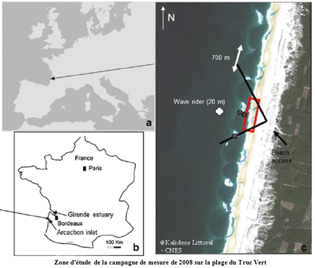
http://www.paralia.fr/jngcgc/10_61_senechal.pdf Campagne de mesure Truc Vert (2008)
- Hierarchy level
- Dataset
Conformance result
- Title
-
Inspire specifications
- Date (Creation)
- 2012-01-16
- Explanation
-
Non assessed
- Pass
- Statement
-
2006 : PEA project financed by the French Defence Ministry
2007 : Research projects launched (INSU and GAME)
2008 : Data Acquired (ex : campaign ECORS Truc Vert)
2009 : Chain of forecasts and boundary conditions for coastal models
Marcket launch and development of the demonstrator
Functional and algorithm specifications for the demonstrator
2010 : Validation report for forecast settings and systems.
Study report of the observations conducted
Report on the demonstrator experiments
2012 : Evaluation and summary of PE ECORS
A significant campaign to measure waves, currents and sea-floor changes (Truc Vert) was used to validate the digital models of changes in the sea floor, in addition to previous campaigns.
These measurements are added to in situ observations (current, pressure, sand content in the water) and the use of video to evaluate bathymetry and surface currents.
Repeated bathymetric readings use hydrographic launches as well as lighter means which are better suited to the surf zone. Detailed analysis of sea states at sea will be used to refine the parameters and assimilation techniques for the measurements taken from space in the sea state forecast models WAM and WAVEWATCH III. Finally, these results will be summarised in a demonstrator model used to characterize beaches along with their environments and dynamics.
- Description
-
Data type :
Hydrography
Physical oceanography
Hydrodynamics
Geology
Precision on the data type :
Bathymetry
Sea State
Currentology
Sedimentology
Measured or observed parameters :
Water depth
Qualitative Observation
Swell currents
Tide currents
Grain size
Sediment concentration
Porosity
Parameters resolution :
Temporal resolution : minimum 15 days of measurements
Current tables
- Description
-
Sampling method : Spatial
Metadata
- File identifier
- a2da6f1e-d471-4d09-98c9-80475420e18e
- Metadata language
- Français
- Other language
-
Language Character encoding English
- Character set
- UTF8
- Hierarchy level
- Series
- Date stamp
- 2024-04-05T07:43:15.126Z
- Metadata standard name
-
ISO 19115:2003/19139 - SEXTANT
- Metadata standard version
-
1.0
- Metadata author
-
Organisation name Individual name Electronic mail address Role Sextant
Local service desk
accessData
Overviews
)))