licensed areas for marine aggregates extraction (in the framework of the french mining code)
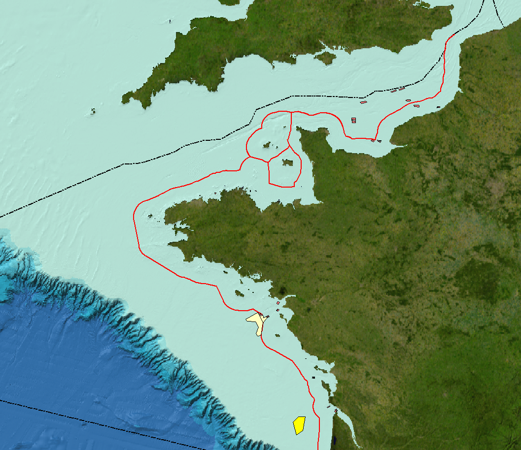
Licensed perimeters for marine aggregates extraction and deposit exploration and applications under consideration in mainland France.
Simple
- Title
-
licensed areas for marine aggregates extraction (in the framework of the french mining code)
- Date (Publication)
- 2008-11-27T00:00:00
- Date (Revision)
- 2023-03-27T00:00:00
- Citation identifier
- IFR_GRA_SITES_EXPLOITATION
- Presentation form
- Digital map
- Abstract
-
Licensed perimeters for marine aggregates extraction and deposit exploration and applications under consideration in mainland France.
- Credit
-
Ifremer
- Status
- On going
- Point of contact
-
Organisation name Individual name Electronic mail address Role Ifremer
Simplet Laure
Author Ifremer - Géosciences Marines
Publisher
- Maintenance and update frequency
- Biannually
-
Thèmes Sextant
-
-
/Regulation and Management/Usage Regulations/Plot or Concession
-
- Theme
-
-
MSFD
-
INSPIRE priority data set
-
- Place
-
-
France
-
-
GEMET - INSPIRE themes, version 1.0
-
-
Area management/restriction/regulation zones and reporting units
-
-
DCSMM : Descripteurs
-
-
D6: Sea-floor Integrity
-
D7: Hydrographical Conditions
-
-
Sous-regions marines
-
-
/Metropolitan France/Bay of Biscay
-
/Metropolitan France/Channel-North Sea
-
/Metropolitan France/Celtic Seas
-
-
Cadre Réglementaire - SIMM
-
-
Maritime Spatial Planning Directive (MSP)
-
Marine Strategy Framework Directive (MSFD)
-
-
Thématiques - SIMM
-
-
/Uses and Human Activities/Industry and energy
-
- Use limitation
-
Données sous Licence ouverte / Open licence : http://www.etalab.gouv.fr/pages/licence-ouverte-open-licence-5899923.html
- Access constraints
- Other restrictions
- Other legal constraints
-
Obligation de quote reference (data sourcing)
- Spatial representation type
- Vector
- Denominator
- 20000
- Language
- Français
- Character set
- UTF8
- Topic category
-
- Environment
))
- Supplemental Information
-
The licensed perimeters were created using coordinates featured in the ministerial orders and decrees defining usage perimeters.
The fields in the attributing table are as follows:
NOM= site name ; DEPARTEMEN= department (administrative area) in charge of the case ; ETAT= site status (extraction underway, applications in progress) ; MATERIAUX= type of sediments extracted ; QUANTITE_A= maximum extraction volume permitted per year (m3) according to the terms of the prefectural decree authorising the work; QUANTITE_D= maximum volume (m3) per year which the applicant wishes to extract; DUREE_A= duration of the validity of the mining agreement defined by ministerial decree (or order) ; DUREE_D= duration of the mining agreement requested by the applicant; DATE_DEB= start date of license; DATE_FIN= end date of license; SURFACE= area of the site in km² ; PROFONDEUR= minimum depth (in m) at the site; DIST_COTE= minimum distance from the closest coastline (in km); ENTREPRISE= company(ies) holding or requesting a mining agreement; NAVIRES= ships which can operate at the site; REFREGLEME= regulatory references having been granted the mining agreement and authorisation to begin work; DOC_REF= Official documentation in which the ministerial decree or order relating to the concession appeared; LAT_pt_med= Latitude of the centroid of the site’s perimeter (in ellipsoid WGS84) ; LON_pt_med= Longitude of the centroid of the site’s perimeter (in ellipsoid WGS84).
- Reference system identifier
- EPSG / WGS 84 (EPSG:4326) / 7.9
- Topology level
- Geometry only
- Geometric object type
- Surface
- Geometric object count
- 63
Distributor
- Distributor contact
-
Organisation name Individual name Electronic mail address Role Ifremer
Dissemination Unit
- Distributor format
-
Name Version ESRI
10
- OnLine resource
-
Protocol Linkage Name OGC:WMS
https://sextant.ifremer.fr/services/wms/granulats_marins IFR_GRA_SITES_EXPLOITATION
FILE
IFR_GRA_SITES_EXPLOITATION
OGC:WFS
https://sextant.ifremer.fr/services/wfs/granulats_marins IFR_GRA_SITES_EXPLOITATION
WWW:LINK
https://camino.beta.gouv.fr/titres?vue=carte&zoom=5¢re=46.2271034,2.5000000 CAMINO
- OnLine resource
-
Protocol Linkage Name WWW:LINK-1.0-http--metadata-URL
https://doi.org/10.12770/a96b7ba0-a1bc-11dd-9201-000086f6a62e Digital Object Identifier (DOI)
- Hierarchy level
- Dataset
Conformance result
- Title
-
INSPIRE Data Specification for the spatial data theme Area management/restriction/regulation zones and reporting units
- Date (Publication)
- 2013-02-04
- Explanation
-
Non assessed
- Pass
- Statement
-
The map rectangles were created using coordinates featured in the ministerial orders and decrees defining usage perimeters.
Metadata
- File identifier
- a96b7ba0-a1bc-11dd-9201-000086f6a62e
- Metadata language
- Français
- Other language
-
Language Character encoding English
- Character set
- UTF8
- Hierarchy level
- Dataset
- Date stamp
- 2023-12-11T15:55:53.99Z
- Metadata standard name
-
ISO 19115:2003/19139 - SEXTANT
- Metadata standard version
-
1.0
- Metadata author
-
Organisation name Individual name Electronic mail address Role Ifremer
Satra Le Bris Catherine
Local service desk
)))