Physical environment - In situ data - Bottom temperature collected during the International Bottom Trawl Survey in January (1980-2010)
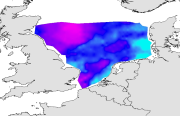
Temperature and salinity were measured, in situ at sea surface and at bottom during the IBTS surveys from 1980 to 2010 . Temperature and salinity were measured using CTD probe. The IBTS survey, which takes place each year in January, gives a good illustration of winter conditions.
Simple
- Title
-
Physical environment - In situ data - Bottom temperature collected during the International Bottom Trawl Survey in January (1980-2010)
- Alternate title
-
IBTS_environment_geostatS
- Date (Publication)
- 2012-03-19T00:00:00
- Citation identifier
- CHARM_BTEMP_IBTS_1980-2010
- Presentation form
- Digital map
- Other citation details
-
Source CHARM Consortium
- Abstract
-
Temperature and salinity were measured, in situ at sea surface and at bottom during the IBTS surveys from 1980 to 2010 . Temperature and salinity were measured using CTD probe. The IBTS survey, which takes place each year in January, gives a good illustration of winter conditions.
- Credit
-
IFREMER
- Credit
-
CHARM consortium
- Status
- Completed
- Point of contact
-
Organisation name Individual name Electronic mail address Role Ifremer
Franck Coppin
Production Unit CHARM Consortium
CHARM Consortium
Production center
- Maintenance and update frequency
- As needed
- Discipline
-
-
Environment data set
-
CHARM
-
-
GEMET - INSPIRE themes, version 1.0
-
-
Habitats et biotopes
-
-
external.theme.gemet
-
-
ressource halieutique
-
- Use limitation
-
research-only
- Access constraints
- License
- Other legal constraints
-
Has to be cited this way in maps : "Source CHARM Consortium"
- Other legal constraints
-
Has to be cited this way in bibliography : "Carpentier A, Martin CS, Vaz S (Eds.), 2009. Channel Habitat Atlas for marine Resource Management, final report / Atlas des habitats des ressources marines de la Manche orientale, rapport final (CHARM phase II). INTERREG 3a Programme, IFREMER, Boulogne-sur-mer, France. 626 pp. & CD-rom"
- Spatial representation type
- Grid
- Denominator
- 2500
- Language
- Français
- Language
- English
- Character set
- UTF8
- Topic category
-
- Oceans
- Biota
- Environment
- Environment description
-
Microsoft Windows XP ; ESRI ArcGIS 9.x
- Geographic identifier
- Eastern English Channel
))
- Begin date
- 1989-01-01
- End date
- 2007-12-31
- Reference system identifier
- WGS 84 (EPSG:4326)
- Number of dimensions
- 2
- Dimension name
- Column
- Dimension size
- 768
- Resolution
- 0.009 degree
- Dimension name
- Row
- Dimension size
- 660
- Resolution
- 0.009 degree
- Cell geometry
- Area
- Transformation parameter availability
Distributor
- Distributor contact
-
Organisation name Individual name Electronic mail address Role Ifremer - Centre de Brest
Dissemination Unit
- Distributor format
-
Name Version
- OnLine resource
-
Protocol Linkage Name OGC:WMS
https://sextant.ifremer.fr/services/wms/wms_charm3 CHARMIII_IBTSQ1_BTEMP_1980
OGC:WMS
https://sextant.ifremer.fr/services/wms/wms_charm3 CHARMIII_IBTSQ1_BTEMP_1981
OGC:WMS
https://sextant.ifremer.fr/services/wms/wms_charm3 CHARMIII_IBTSQ1_BTEMP_1982
OGC:WMS
https://sextant.ifremer.fr/services/wms/wms_charm3 CHARMIII_IBTSQ1_BTEMP_1983
OGC:WMS
https://sextant.ifremer.fr/services/wms/wms_charm3 CHARMIII_IBTSQ1_BTEMP_1984
OGC:WMS
https://sextant.ifremer.fr/services/wms/wms_charm3 CHARMIII_IBTSQ1_BTEMP_1985
OGC:WMS
https://sextant.ifremer.fr/services/wms/wms_charm3 CHARMIII_IBTSQ1_BTEMP_1986
OGC:WMS
https://sextant.ifremer.fr/services/wms/wms_charm3 CHARMIII_IBTSQ1_BTEMP_1987
OGC:WMS
https://sextant.ifremer.fr/services/wms/wms_charm3 CHARMIII_IBTSQ1_BTEMP_1988
OGC:WMS
https://sextant.ifremer.fr/services/wms/wms_charm3 CHARMIII_IBTSQ1_BTEMP_1989
OGC:WMS
https://sextant.ifremer.fr/services/wms/wms_charm3 CHARMIII_IBTSQ1_BTEMP_1990
OGC:WMS
https://sextant.ifremer.fr/services/wms/wms_charm3 CHARMIII_IBTSQ1_BTEMP_1991
OGC:WMS
https://sextant.ifremer.fr/services/wms/wms_charm3 CHARMIII_IBTSQ1_BTEMP_1992
OGC:WMS
https://sextant.ifremer.fr/services/wms/wms_charm3 CHARMIII_IBTSQ1_BTEMP_1993
OGC:WMS
https://sextant.ifremer.fr/services/wms/wms_charm3 CHARMIII_IBTSQ1_BTEMP_1994
OGC:WMS
https://sextant.ifremer.fr/services/wms/wms_charm3 CHARMIII_IBTSQ1_BTEMP_1995
OGC:WMS
https://sextant.ifremer.fr/services/wms/wms_charm3 CHARMIII_IBTSQ1_BTEMP_1996
OGC:WMS
https://sextant.ifremer.fr/services/wms/wms_charm3 CHARMIII_IBTSQ1_BTEMP_1997
OGC:WMS
https://sextant.ifremer.fr/services/wms/wms_charm3 CHARMIII_IBTSQ1_BTEMP_1998
OGC:WMS
https://sextant.ifremer.fr/services/wms/wms_charm3 CHARMIII_IBTSQ1_BTEMP_1999
OGC:WMS
https://sextant.ifremer.fr/services/wms/wms_charm3 CHARMIII_IBTSQ1_BTEMP_2000
OGC:WMS
https://sextant.ifremer.fr/services/wms/wms_charm3 CHARMIII_IBTSQ1_BTEMP_2001
OGC:WMS
https://sextant.ifremer.fr/services/wms/wms_charm3 CHARMIII_IBTSQ1_BTEMP_2002
OGC:WMS
https://sextant.ifremer.fr/services/wms/wms_charm3 CHARMIII_IBTSQ1_BTEMP_2003
OGC:WMS
https://sextant.ifremer.fr/services/wms/wms_charm3 CHARMIII_IBTSQ1_BTEMP_2004
OGC:WMS
https://sextant.ifremer.fr/services/wms/wms_charm3 CHARMIII_IBTSQ1_BTEMP_2005
OGC:WMS
https://sextant.ifremer.fr/services/wms/wms_charm3 CHARMIII_IBTSQ1_BTEMP_2006
OGC:WMS
https://sextant.ifremer.fr/services/wms/wms_charm3 CHARMIII_IBTSQ1_BTEMP_2007
OGC:WMS
https://sextant.ifremer.fr/services/wms/wms_charm3 CHARMIII_IBTSQ1_BTEMP_2008
OGC:WMS
https://sextant.ifremer.fr/services/wms/wms_charm3 CHARMIII_IBTSQ1_BTEMP_2009
OGC:WMS
https://sextant.ifremer.fr/services/wms/wms_charm3 CHARMIII_IBTSQ1_BTEMP_2010
COPYFILE
1980
COPYFILE
1981
COPYFILE
1982
COPYFILE
1983
COPYFILE
1984
COPYFILE
1985
COPYFILE
1986
COPYFILE
1987
COPYFILE
1988
COPYFILE
1989
COPYFILE
1990
COPYFILE
1991
COPYFILE
1992
COPYFILE
1993
COPYFILE
1994
COPYFILE
1995
COPYFILE
1996
COPYFILE
1997
COPYFILE
1998
COPYFILE
1999
COPYFILE
2000
COPYFILE
2001
COPYFILE
2002
COPYFILE
2003
COPYFILE
2004
COPYFILE
2005
COPYFILE
2006
COPYFILE
2007
COPYFILE
2008
COPYFILE
2009
COPYFILE
2010
- Hierarchy level
- Dataset
- Statement
-
he data was extracted by year and quarter from the ICES oceanographic database.
- Description
-
Geostatistical interpolation : the spatial variation of data were analysed using GENSTAT (GENSTAT 7 Committee, 2004), which is a GENeral STATistics package including the main geostatistical tools. It computes experimentala variograms, fits these with various authorised mathematical models and uses them to calculate kriged estimates on a fine regular grid (of latitudes and longitudes). The grid of points was imported into ArcMap and interpolated with the Spatial Analyst extension in order to create a continuous raster of 1 km² resolution. The resulting maps illustrate the spatial distributions and the variations over time for variables studied in CHARM's area. For legends of maps, approximates of the 5th and the 95th quantiles were used for the minimales and maximales values respectively. Average and standard deviation maps were computed based on all interpolated maps over all the period studied
- Description
-
North Sea oceanography
Metadata
- File identifier
- abcce177-ec9e-477c-9dd1-f5f20517e643
- Metadata language
- English
- Character set
- UTF8
- Hierarchy level
- Dataset
- Date stamp
- 2020-06-04T00:28:29
- Metadata standard name
-
ISO 19115:2003/19139 - SEXTANT
- Metadata standard version
-
1.0
- Metadata author
-
Organisation name Individual name Electronic mail address Role Ifremer
Erwann Quimbert
Local service desk
accessData
Overviews
)))