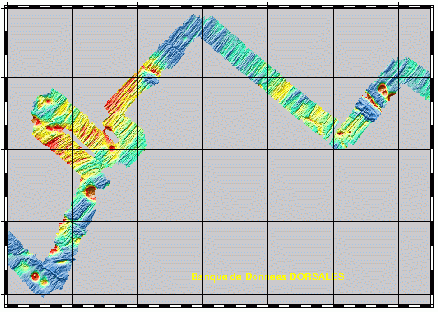
Multibeam bathymetry - Zone 3 - Pacantarctic cruise - 250m/500m/1000m
Geophysical and geochemical study of the Pacific-Antarctic ridge between S65/W175 and S60/W150. The first objective was to contribute to the understanding and modelling of the mechanisms of ocean ridge functioning on the scale of the basic accretion unit (< 100 km). The second was to study the zoning of the upper mantle on various scales, through investigating the geochemical signature of rocks from the axial valley. This cruise falls under the framework of the Inter-Ridge programme and is the result of cooperation between IFREMER/DRO/GM, INSU (CNRS,IPG, GRGS), Washington State University, Scripps (University of California) and the University of Chiba (Japan).
Simple
- Title
-
Multibeam bathymetry - Zone 3 - Pacantarctic cruise - 250m/500m/1000m
- Date (Creation)
- 2002-11-26
- Citation identifier
- IFR_MBAN_DORSALES_PACIF_ZONE3_BATHY_R
- Citation identifier
- DOI:10.12770/ae029d6e-41ba-48d9-84de-8e6da0bd155d
- Abstract
-
Geophysical and geochemical study of the Pacific-Antarctic ridge between S65/W175 and S60/W150. The first objective was to contribute to the understanding and modelling of the mechanisms of ocean ridge functioning on the scale of the basic accretion unit (< 100 km). The second was to study the zoning of the upper mantle on various scales, through investigating the geochemical signature of rocks from the axial valley. This cruise falls under the framework of the Inter-Ridge programme and is the result of cooperation between IFREMER/DRO/GM, INSU (CNRS,IPG, GRGS), Washington State University, Scripps (University of California) and the University of Chiba (Japan).
- Credit
-
The project is part of the national program Dorsales and represents the French contribution to the InterRidge Data Banks project (see InterRidge News 1997, vol. 6/1 and 1999, vol. 8/1).
- Point of contact
-
Organisation name Individual name Electronic mail address Role Ifremer
Publisher Laboratoire d’Etudes en Geophysique et Oceanographie Spatiales – CNRS
Briais Anne
Author
-
Thèmes Sextant
-
-
/Physical Environment/Bathymetry/Digital Terrain Model
-
-
GEMET - INSPIRE themes, version 1.0
-
-
Elevation
-
-
Thématiques - SIMM
-
-
/Etat du Milieu/Géologie
-
-
Thématiques - SIMM
-
-
Recherche
-
-
Thématiques - SIMM
-
-
/Etat du Milieu/Bathymétrie
-
-
Sous-regions marines
-
-
/Outre-mer/Océan Indien
-
- Use limitation
- CC-BY (Creative Commons - Attribution)
- Access constraints
- Other restrictions
- Use constraints
- License
- Other legal constraints
-
Géli, L., et al., Evolution of the Pacific-Antarctic Ridge south of the Udintsev Fracture Zone, Science, 278, 1281-1284, 1997
- Spatial representation type
- Grid
- Denominator
- 25000
- Language
- Français
- Character set
- UTF8
- Topic category
-
- Elevation
))
- Reference system identifier
- EPSG / WGS 84 (EPSG:4326) / 8.6
- Number of dimensions
- 2
- Dimension name
- Column
- Resolution
- 0.28616530 minutes
- Dimension name
- Row
- Resolution
- 0.12108899 minutes
- Cell geometry
- Area
- Number of dimensions
- 2
- Dimension name
- Column
- Resolution
- 0.63592289 minutes
- Dimension name
- Row
- Resolution
- 0.26909891 minutes
- Cell geometry
- Area
- Number of dimensions
- 2
- Dimension name
- Column
- Resolution
- 1.27184578 minutes
- Dimension name
- Row
- Resolution
- 0.53824296 minutes
- Cell geometry
- Area
- Distribution format
-
Name Version
- OnLine resource
-
Protocol Linkage Name OGC:WMS
https://sextant.ifremer.fr/services/wms/bathymetrie MOHNS_BATHY
FILE
MOHNS_BATHY
WWW:LINK-1.0-http--metadata-URL
https://doi.org/10.12770/ae029d6e-41ba-48d9-84de-8e6da0bd155d DOI du jeu de données
- OnLine resource
-
Protocol Linkage Name COPYFILE
IFR_MBAN_DORSALES_PACIF_ZONE3_BATHY_250_R_GRD
- OnLine resource
-
Protocol Linkage Name OGC:WMS
https://sextant.ifremer.fr/services/wms/bathymetrie IFR_MBAN_DORSALES_PACIF_ZONE3_BATHY_500_R
FILE
IFR_MBAN_DORSALES_PACIF_ZONE3_BATHY_500_R
- OnLine resource
-
Protocol Linkage Name COPYFILE
IFR_MBAN_DORSALES_PACIF_ZONE3_BATHY_500_R_GRD
- OnLine resource
-
Protocol Linkage Name OGC:WMS
https://sextant.ifremer.fr/services/wms/bathymetrie IFR_MBAN_DORSALES_PACIF_ZONE3_BATHY_1000_R
FILE
IFR_MBAN_DORSALES_PACIF_ZONE3_BATHY_1000_R
- OnLine resource
-
Protocol Linkage Name COPYFILE
IFR_MBAN_DORSALES_PACIF_ZONE3_BATHY_1000_R_GRD
- OnLine resource
-
Protocol Linkage Name WWW:LINK
http://dx.doi.org/10.17600/96010020 DOI de la campagne - PACANTARCTIC
- Hierarchy level
- Dataset
- Statement
-
Sources : Données de la campagne J. Charcot 1988, données Seabeam
- Description
-
0 spline en tension (surface)
- Rationale
-
Interpolation
Content Information
Metadata
- File identifier
- ae029d6e-41ba-48d9-84de-8e6da0bd155d
- Metadata language
- Français
- Other language
-
Language Character encoding English UTF8
- Character set
- UTF8
- Hierarchy level
- Dataset
- Date stamp
- 2020-08-31T11:23:39
- Metadata standard name
-
ISO 19115:2003/19139 - SEXTANT
- Metadata standard version
-
1.0
- Metadata author
-
Organisation name Individual name Electronic mail address Role Laboratoire d’Etudes en Geophysique et Oceanographie Spatiales – CNRS
Briais Anne
Local service desk
accessData
Overviews