PREVIMER Coastal Observations and Forecasts – 4 day forecast (96h) -
The PREVIMER demonstrator is designed for a wide audience, including those who want to obtain short term coastal environmental forecasts for the Channel, Atlantic and Mediterranean coasts, be it for private or professional purposes.
Simple
- Title
-
PREVIMER Coastal Observations and Forecasts – 4 day forecast (96h) -
- Date (Creation)
- 2006-01-01T00:00:00
- Citation identifier
- FR-DCSMM-PDS-BD_PREVIMER
- Presentation form
- Digital profile
- Abstract
-
The PREVIMER demonstrator is designed for a wide audience, including those who want to obtain short term coastal environmental forecasts for the Channel, Atlantic and Mediterranean coasts, be it for private or professional purposes.
- Purpose
-
The main aim of PREVIMER is to continue developing an operational coastal oceanography centre. In order to evaluate the configuration of future operational services, PREVIMER routinely operates thematic models and experimentally shares analyses and forecasts regarding the state of the marine environment in the coastal area on spatial scales ranging from coast, to bay, to specific local areas. A set of observations and digital modelling tools are used to provide 4-day previsions (96h) on sea state, currents, tide levels, temperature and primary production.
In addition, monitoring of an ever-increasing number of biological parameters complements the description of the coastal environment.
- Credit
-
Data Producers : IFREMER, SHOM, Météo-France, CETMEF, Mercator Ocean, IUEM, BRGM, IGN, DIREN - Serveur Producteur Coliane, Institution d'Aménagement de la Vilaine
- Status
- On going
- Point of contact
-
Organisation name Individual name Electronic mail address Role SHOM
LE SQUERE Bruno
Local service desk
- Maintenance and update frequency
- Continual
- Maintenance note
-
Network Duration: perennial Network
- Theme
-
-
Operational oceanography
-
Coastal oceanography
-
Modelling
-
HYCOM
-
WW3
-
Hydrodynamics
-
Sea states
-
Currents
-
Waves
-
Water level
-
Temperature
-
Salinity
-
Tide guage
-
HF Radars
-
Buoys
-
Floats
-
-
GEMET - INSPIRE themes, version 1.0
-
-
Oceanographic geographical features
-
-
Sous-regions marines
-
-
National
-
-
DCSMM : Type d'espace concerné
-
-
Pas d'espace particulier concerné
-
-
DCSMM : Descripteurs
-
-
D7: Hydrographical Conditions
-
-
DCSMM : Méthodes de recueil des données
-
-
Observation par point
-
Observation indirecte
-
Observation directe
-
-
Thèmes Sextant
-
-
/Physical Environment/Coastal Hydrodynamics
-
- Use limitation
-
The experimental PREVIMER site is freely available to internet users and is free of charge.
The information available on the PREVIMER site is for information only.
It cannot be viewed or used, with absolute reliability, for personal or maritime navigation ,
Shellfish gathering
Shellfish farming
Etc.
- Access constraints
- Other restrictions
- Other legal constraints
-
Access to the PREVIMER site implies an understanding and acceptance of these warnings. Under no circumstances does PREVIMER replace the forecasts, warnings and alerts issued by Météo France, not the tide forecasts provided by the SHOM, which are the French national benchmarks.
It must be noted that PREVIMER forecasts are the results of simulations. Consequently they are, by their very nature, tarnished with doubt as they are limited by scientific knowledge and incoming data quality which are required for the model to function and which can occasionally stray from the observed (spatial and temporal) values.
- Use limitation
-
Pricing Method : Free
Visualisation and download.
- Spatial representation type
- Vector
- Denominator
- 500000
- Language
- Français
- Character set
- UTF8
- Topic category
-
- Oceans
))
- Supplemental Information
-
Project leader : IFREMER 2006
SHOM 2006
European Union (FEDER) 2006
Breton Regional Council 2006
Finistère General Council 2006
Brest Métropole Océane 2006
Prime contractor :
IFREMER 2006
SHOM 2006
Backer(s) : IFREMER 2006
SHOM 2006
European Union (FEDER) 2006
The coordinators (Ifremer and the French Navy’s Oceanographic and Hydrographic Service) and partners (Météo France, the centre for technical and waterways studies, Mercator Océan, the Geology and Minerals Bureau, the Research and Development Institute, The European Institute for Marine Studies and the pôles mer Bretagne and PACA) are working together toward developing and implementing the technology and the capacity required for forecasting coastal environments, and distributing this information daily online.
- Reference system identifier
- EPSG / WGS 84 (EPSG:4326) / 7.9
- Topology level
- Geometry only
- Geometric object type
- Complex
- Geometric object count
- 0
- Hierarchy level
- Dataset
Conformance result
- Title
-
Inspire specifications
- Date (Creation)
- 2012-01-16
- Explanation
-
Non assessed
- Pass
- Statement
-
2007 : Implementation, establishment and upload of HF radar observations in the Iroise sea (Vigicote)
27/07/2007 : WW3 wave forecasting channel went live
12/08/2012 : HYCOM Channel & Biscay model went live
31/12/2012 : Development of the position of forecaster
Since 2006, PREVIMER has been gradually distributing the results of models attributed to specific geographical areas, from French mainland coasts to areas of particular interest:
• Hydrodynamic circulation (currents and water levels),
• Temperature and salinity,
• Sea state
• Biochemical status and primary production
PREVIMER also provides observation data and model results as digital files, particularly for use by researchers and consultants.
The BD COURANTS database is dedicated to fixed-point current data (data from fixed current metres, occasional Doppler current metres and profilers).
There are many different methods for observing marine currents :
- The Lagrangian method, which involves monitoring particles in space and time and reproducing their movements at a given immersion
- The Eulerian method which involves observing the evolution of the current (speed and direction) at a fixed position in the ocean (occasional measurements) over time (either at a given immersion, or for the whole water column)
- Measurements from devices on board ships which involve measuring current (speed and direction), during a trip (either at a given immersion, or for the whole water column)
- High Frequency Radar measurements, which involve reproducing the field of radial speed for surface currents after analyzing signals backscattered by waves.
Current data from drifting buoys, measurements from ships, or by HF radar are not managed in this database (see Coriolis).
The time series for current directions and speeds stem from all types of immersed current metres (mechanical current metres, electromagnetic current metres and acoustic current metres).
Currents are measured either upon immersion of the current metre (ex : rotor current metre, or occasional Doppler current metre) or at predefined layers for the whole water column (ADCP profiler).
- Description
-
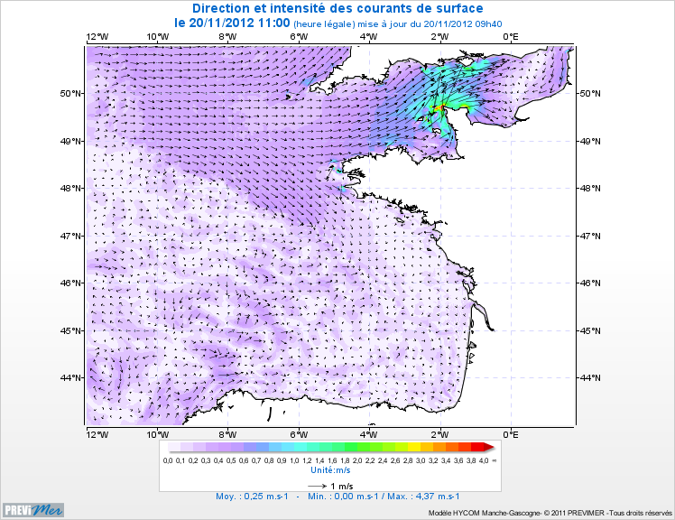
HYCOM is a "hybrid vertical coordinate" model, which means that the calculation grid can, at any given time, be adapted to the configuration of the area and the physical phenomenon that we are trying to represent. Notably, this scalable grid can be adapted to regions with great variations of density when bathymetry is particularly complex.
The HYCOM model is being developed by an international consortium which includes the participation of the United States, Norway and France (SHOM). Laboratories are currently using this code in the United Kingdom, Portugal and Greece.
The Channel-Bay of Biscay HYCOM model, for which the results are presented here, uses the following data as input :
• meteorological forcing: data relating to wind, solar flow, air temperature, etc. provided by the Arpège model from Météo France
• open border forcing : border conditions, excluding tides, stem from the Mercator-Océan global model at 1/12°, the tide is forced from the output of the MOG2D model from LEGOS,
• river forcing : the flow of the Seine, the Loire, the Gironde and the Adour come from the Regional Environmental Agencies
• Inclusion of satellite measurements (altimetry, surface temperature) and in-situ observations (buoys, temperature/salinity) has been included in the model in search mode. An operational version will soon be available for use.
For the HYCOM model, additional information is available at
- Description
-
Data type : coastal hydrodynamics
Precision on the data type : in-situ measurements
WW3 Models
Measured or observed parameters :
Surface Currents
Sea levels, maximum/minimum
Waves
Parameters resoulution :
Range : 150 km
Radial resolution : 1,5km
Average azimuth resolution : below 10°
Update frequency :
10 min
Near real-time via the refmar.shom.fr portal (updated hourly)
Forecasts updated twice daily (5:00 and 17:00 UT)
Observation frequency :
Near real-time
1 mesurement per minute
Five-day forecast
- Description
-
Data type :
Coastal hydrodynamics
Hydrology
Precision on the data type :
Three dimensional HYCOM models
Measured or observed parameters :
Surface currents,
Sea level
Temperature
Salinity
Parameters resoulution :
3D mesh with 1.7 km of horizontal resolution and 32 vertical levels
Update frequency :
Daily
Observation frequency :
Five-day forecast
- Description
-
Sampling method : Spatial
- Description
-
device associated : VIGICOTE, CORIOLIS, RONIM, REFMAR,
Météo-France buoys ; SOAP
Metadata
- File identifier
- afedaca5-b947-4a16-97a8-32f97a4f6467
- Metadata language
- Français
- Other language
-
Language Character encoding English
- Character set
- UTF8
- Hierarchy level
- Series
- Date stamp
- 2020-06-04T00:32:27
- Metadata standard name
-
ISO 19115:2003/19139 - SEXTANT
- Metadata standard version
-
1.0
- Metadata author
-
Organisation name Individual name Electronic mail address Role Sextant
Local service desk
accessData
Overviews
)))