Combined Mean Dynamic Topography
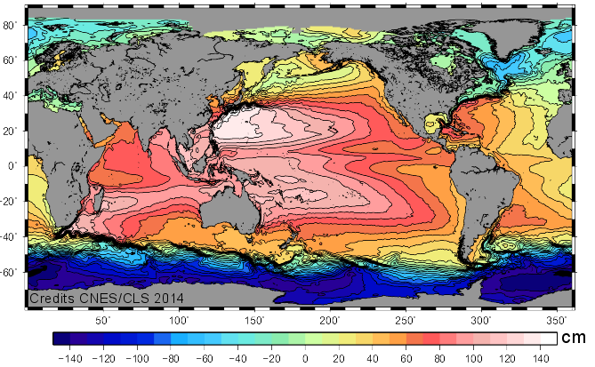
The Mean Dynamic Topography MDT-CNES-CLS22 is an estimate of the mean over the 1993-2012 period of the sea surface height above geoid. This is consistent with the reference time period also used in the SSALTO DUACS products.
Simple
- Title
-
Combined Mean Dynamic Topography
- Date (Creation)
- 2022-06-15
- Date (Publication)
- 2023-02-24
- Abstract
-
The Mean Dynamic Topography MDT-CNES-CLS22 is an estimate of the mean over the 1993-2012 period of the sea surface height above geoid. This is consistent with the reference time period also used in the SSALTO DUACS products.
- Credit
-
AVISO+
- Point of contact
-
Organisation name Individual name Electronic mail address Role AVISO+
AVISO+
Local service desk AVISO+
AVISO+
Dissemination Unit CNES
Publisher CLS
Author CNES
Owner
-
Centre de données ODATIS
-
-
CDS-SAT-AVISO
-
- Keywords
-
-
topographie dynamique moyenne
-
-
Cersat - Format
-
-
/NetCDF/NetCDF 4
-
-
Cersat - Processing level
-
-
L4
-
-
ODATIS aggregation parameters and Essential Variable names
-
-
Sea surface height
-
-
Type de jeux de donnée ODATIS
-
-
/Observational data/satellite
-
- Use limitation
- Licence ouverte
- Access constraints
- License
- Use constraints
- License
- Other legal constraints
-
Conditions of use are described in the Licence : https://www.aviso.altimetry.fr/fileadmin/documents/data/License_Aviso.pdf.
Any use of this product must cite the DOI https://doi.org/10.24400/527896/a01-2023.003
- Spatial representation type
- Grid
- Language
- Français
- Character set
- UTF8
- Topic category
-
- Oceans
))
- Begin date
- 1993-01-01
- Geometric object type
- Complex
- Distribution format
-
Name Version
- OnLine resource
-
Protocol Linkage Name WWW:LINK
https://www.aviso.altimetry.fr/en/data/products/auxiliary-products/mdt.html Plus d'information sur AVISO+
WWW:LINK
ftp://LOGIN:PASSWORD@ftp-access.aviso.altimetry.fr/auxiliary/mdt Accès authentifié aux données via FTP
OGC:WMS
https://tds-odatis.aviso.altimetry.fr/thredds/catalog/wms/dataset-mdt-cnes-cls22-global?service=WMS&version=1.3.0&request=GetCapabilities mdt
WWW:DOWNLOAD
https://tds%40odatis-ocean.fr:odatis@tds-odatis.aviso.altimetry.fr/thredds/catalog/ncss/dataset-mdt-cnes-cls22-global/dataset.html TDS NetCDFSubset MDT
OGC:WMS
https://tds-odatis.aviso.altimetry.fr/thredds/catalog/wms/dataset-mdt-cnes-cls22-global?service=WMS&version=1.3.0&request=GetCapabilities u
OGC:WMS
https://tds-odatis.aviso.altimetry.fr/thredds/catalog/wms/dataset-mdt-cnes-cls22-global?service=WMS&version=1.3.0&request=GetCapabilities v
DOI
https://doi.org/10.24400/527896/a01-2023.003 DOI dataset
- Hierarchy level
- Dataset
- Statement
-
Contents: mean over the 1993-2012 period of the sea surface height above geoid. The MDT_CNES-CLS13 is an estimate of the ocean MDT for the 1993-2012 period. Since April 2014 (Duacs 2014, v15.0 version), the Ssalto/Duacs (M)SLA products are computed relative to 1993-2012 period that is consistent with this new MDT CNES-CLS13.
Use: ocean circulation, operational oceanography
Description: based on 2 years of GOCE data, 7 years of GRACE data, and 20 years of altimetry and in-situ data (hydrologic and drifters data).
We first compute a first guess: a medium scale of Mean Dynamic Topography using only satellite data (gravimetry and altimetry). The raw difference of Mean Sea Surface with geoid model is filtered using an optimal filter to remove noise and residual geodetic signal.
Beside we compute synthetic estimate of MDT and mean geostrophic current from oceanic in-situ data (T/S profiles and drifters).
First, the data are processed to have the same physical content as altimetry:
the drifters (SVP and Argo drifting at the surface) are processed to only extract the geostrophic component
also deep baroclinic and barotropic components are added to dynamic height computed from T/S profiles.
Then sea level anomalies are interpolated and subtracted from in-situ measurements of the ocean state to estimate a mean: MDT and the corresponding mean geostrophic surface velocities.
Then, using a multivariate objective analysis, the synthetic estimates of mean heights and mean velocities are combined to improve the first guess of the MDT.
Finally, a validation is done by comparing this version to other MDTs and independent in-situ data.
References
- Jousset S., Mulet S., Wilkin J., Greiner E., Dibarboure G. and Picot N.: “New global Mean Dynamic Topography CNES-CLS-22 combining drifters, hydrological profiles and High Frequency radar data”, OSTST 2022, https://doi.org/10.24400/527896/a03-2022.3292.
Metadata
- File identifier
- b01f1bbb-c04f-42e2-8e22-6367081c368f
- Metadata language
- Français
- Other language
-
Language Character encoding English UTF8
- Character set
- UTF8
- Hierarchy level
- Dataset
- Date stamp
- 2025-02-24T13:25:31.52599Z
- Metadata standard name
-
ISO 19115:2003/19139 - SEXTANT
- Metadata standard version
-
1.0
)))