Oceanographic cruise - LANGOLF (Langoustine Bay of Biscay)
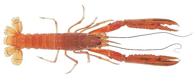
Calculating Nephrops stock abundance index in the Grande Vasière (Bay of Biscay), size and sex structure; spatial distribution of population per sedimentary unit. Macroscopic observation of stages of sexual maturity in females. Abundance index estimations for related species. Calcified parts were removed to determine the age of species of commercial interest whose stock dynamics are being monitored. Sexual maturity stages in sole, angler fish and hake. Temperature, salinity and depth logs taken (Cruises FIS).
Simple
- Title
-
Oceanographic cruise - LANGOLF (Langoustine Bay of Biscay)
- Date (Publication)
- 2006-04-07
- Citation identifier
- FR-DCSMM-PDS-LANGOLF
- Presentation form
- Digital profile
- Abstract
-
Calculating Nephrops stock abundance index in the Grande Vasière (Bay of Biscay), size and sex structure; spatial distribution of population per sedimentary unit. Macroscopic observation of stages of sexual maturity in females. Abundance index estimations for related species. Calcified parts were removed to determine the age of species of commercial interest whose stock dynamics are being monitored. Sexual maturity stages in sole, angler fish and hake. Temperature, salinity and depth logs taken (Cruises FIS).
- Purpose
-
The aims of the cruise are:
(i) To estimate an abundance index for the langoustine stock size-structure by sex.
(ii) Spatial distribution by sedimentary unit of the population
(iii) Macroscopic observation of stages of sexual maturity in females.
(iv) To estimate abundance indicators for species associated with experimental catches.
(v) (particularly hake, galathea, monkfish, pouting, blue hake, sole).
(vi) To collect and sample calcified parts to determine the age of fishes (species of commercial interest whose dynamics are monitored).
(vii) Sampling by sedimentary strata of associated benthic microfauna and megafauna.
- Credit
-
IFREMER
- Status
- On going
- Point of contact
-
Organisation name Individual name Electronic mail address Role IFREMER
IFREMER SIH
Author IFREMER
IFREMER SIH
Publisher
- Maintenance and update frequency
- Historical
- Theme
-
-
Species
-
Assembly
-
Benthos
-
Sedimentary strata
-
Langoustine, hake
-
Size, sex
-
Stratified sampling
-
-
GEMET - INSPIRE themes, version 1.0
-
-
Environmental monitoring facilities
-
-
Sous-regions marines
-
-
/Metropolitan France/Bay of Biscay
-
-
DCSMM : Type d'espace concerné
-
-
Pas d'espace particulier concerné
-
-
DCSMM : Descripteurs
-
-
D3: Commercially Exploited Species
-
-
DCSMM : Méthodes de recueil des données
-
-
Observation directe
-
-
Thèmes Sextant
-
-
/Human Activities/Oceanographical Cruises
-
-
SIH - Types de jeu de données
-
-
/Observed Data/Campaigns
-
-
SIH - Façade maritime
-
-
Atlantique
-
-
Cadre Réglementaire - SIMM
-
-
Marine Strategy Framework Directive (MSFD)
-
-
Thématiques - SIMM
-
-
/Uses and Human Activities/Fisheries and aquaculture
-
-
Type de jeux de donnée ODATIS
-
-
/in-situ observations/Sea cruises
-
- Access constraints
- Restricted
- Association Type
- Cross reference
- Initiative Type
- Platform
- Language
- Français
- Character set
- UTF8
- Topic category
-
- Oceans
- Begin date
- 2006-04-07
- End date
- 2013-05-21
))
- Supplemental Information
-
Financers :
IFREMER
Europe
Direction Générale des Affaires Maritimes, de la Pêche et de l'Aquaculture (DGAMPA)
- Distribution format
-
Name Version
- OnLine resource
-
Protocol Linkage Name OGC:WMS
https://sextant.ifremer.fr/services/wms/sismer campagnes_LANGOLF
WWW:LINK
https://sih.ifremer.fr/prive/Acces-aux-donnees/Extractions/Campagnes/Donnees-Campagnes-halieutiques Access to SIH fisheries cruises data
WWW:LINK
https://sih-indices-campagnes.ifremer.fr/ Population and community indices from fisheries monitoring cruises in which Ifremer participates
- Hierarchy level
- Dataset
Conformance result
- Title
-
Inspire specifications
- Date (Creation)
- 2012-01-16
- Explanation
-
Not rated
- Pass
- Statement
-
On the entire sector, with a total surface area of around 11680 km², five sedimentary strata are defined according to mud content and origin. Sampling method: random stratified, proportionally allocated a ratio which takes into account: (1) the surface of each layer and (2) an index relating to the concentration of fishing vessels.
The locations are trawled randomly
Fishing gear consists of twin trawls (two trawlers connected by their wing points at the centre) much like those used in commercial fishing, except that the mesh in the codend is only 20mm fully-stretched, in order to retain immature individuals.
Each trawl is equipped with a SCANMAR “headline” and “wing point” equipment in order to check the geometry of the trawl gear during trawls (vertical and horizontal openings),and to define the moment when trawling on the sea floor begins. The panels are equipped with a GEONET device which provides data on the geometry of the gear and temperature at the sea floor.
Thanks to these devices, it is possible to calculate the surface area of the sea floor which has been effectively cleared for each sampling unit. A sensor is connected to the trawler’s headline in order to obtain hydrological information (pressure, temperature and conductivity).
The standard sampling plan includes 70 trawling locations for duration of 30 minutes. Different measurements are taken during each trawl.
1) Trawler performance
2) Biological observation of all species
3) Hydrological and Bathmetric measurements
• Sampling plan(s) :
Random, stratified
• Precision on the type of data :
Lepidorhombus whiffiagonis, Lophius budegassa, Lophius piscatorius, Merluccius merluccius, Solea vulgaris, mullus surmulutus, Nephrops norvegicus
• Parameter(s) observed or measured :
Size
Sex
Maturity
Collection of otoliths
Identification
Assembly
Abundance
• Resolution of parameter(s) :
By fishing operation, systematic analysis of scientific fishing catches
• Format(s):
The available data exist in the format: csv
- Description
-
Data type :
Actinopterygii
Crustaceans
Benthos
Precision on the data type :
Lepidorhombus whiffiagonis, Lophius budegassa, Lophius piscatorius,Merluccius merluccius, Solea vulgaris, mullus surmulutus, Nephrops norvegicus
Measured or observed parameters :
Size
Sex
Maturity
Otolith sampling
Identification
Assembly
Abundance
Update frequency : annual
Observation frequency : yearly, for 14 days
Metadata
- File identifier
- b531674a-b4f1-4730-ab54-4e0f9c4be641
- Metadata language
- Français
- Other language
-
Language Character encoding English
- Character set
- UTF8
- Parent identifier
-
Campagnes océanographiques - Observations pour la surveillance halieutique
99e16a35-8090-4897-aa2b-c5c0951aabea
- Hierarchy level
- Series
- Date stamp
- 2023-09-26T13:10:34.126Z
- Metadata standard name
-
ISO 19115:2003/19139 - SEXTANT
- Metadata standard version
-
1.0
- Metadata author
-
Organisation name Individual name Electronic mail address Role IFREMER SIH
Local service desk
accessData
Overviews
)))