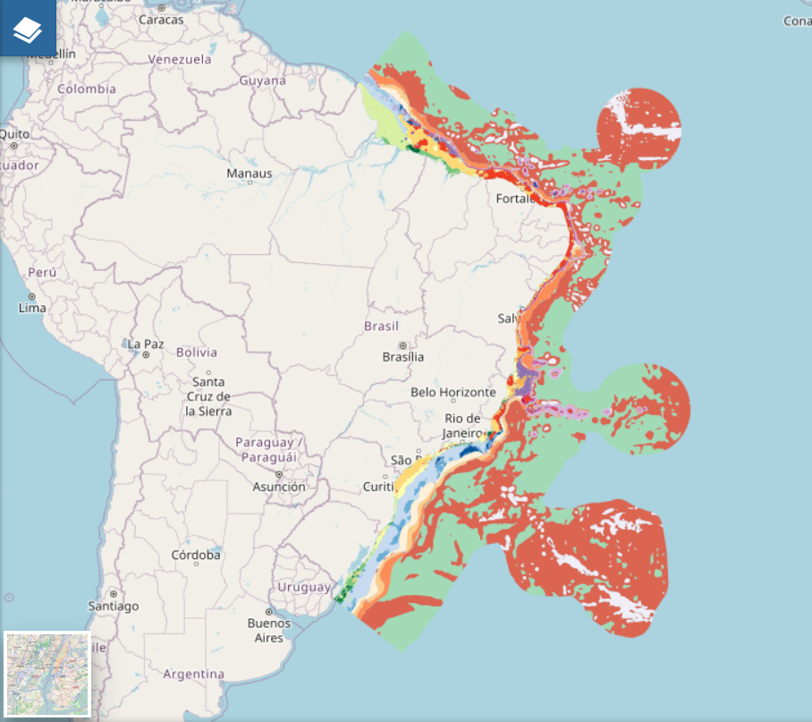
Benthic habitats using EUNIS classification for the Brazilian EEZ
The dataset contains the shapefile of marine benthic broad habitats classified according to EUNIS classification for the Brazilian Exclusive Economic Zone region. It was developed using open access databases and GIS operations to develop two intermediate layers: (i) biological zones and (ii) substrate type. Both layers were combined to form the first continuous map of marine habitats for the entire region.
Simple
- Title
-
Benthic habitats using EUNIS classification for the Brazilian EEZ
- Date (Publication)
- 2024-04-30
- Abstract
-
The dataset contains the shapefile of marine benthic broad habitats classified according to EUNIS classification for the Brazilian Exclusive Economic Zone region. It was developed using open access databases and GIS operations to develop two intermediate layers: (i) biological zones and (ii) substrate type. Both layers were combined to form the first continuous map of marine habitats for the entire region.
- Credit
-
Federal University of Santa Catarina (Brazil)
- Credit
-
Federal Institute of Education, Science and Technology of Rio Grande do Sul (Brazil)
- Credit
-
AZTI (Spain)
- Credit
-
University of São Paulo (Brazil)
- Point of contact
-
Organisation name Individual name Electronic mail address Role Federal University of Santa Catarina
Vitor De Souza
Product manager Federal Institute of Education, Science and Technology of Rio Grande do Sul
Tiago Gandra
Product manager Federal University of Santa Catarina
Jarbas Bonetti
Product manager AZTI, Marine Research
Ibon Galparsoro
Product manager University of São Paulo
Luis Conti
Product manager Federal University of Santa Catarina
Marinez Scherer
Product manager
-
Mission Atlantic - BODC Parameters
-
-
/Environment/Habitat
-
-
Mission Atlantic - Case Studies
-
-
South Brazilian Shelf
-
-
Mission Atlantic - Resources
-
-
MISSION ATLANTIC Results
-
Data
-
-
Mission Atlantic - Work Package
-
-
WP4 Benthic Mapping
-
-
Mission Atlantic - Data type (DMP)
-
-
Modelling data
-
Spatial data products
-
- Use constraints
- Other restrictions
- Other legal constraints
-
Attribution (CC BY)
- Access constraints
- Other restrictions
- Other legal constraints
- There are no limitations on public access to spatial data sets and services.
- Spatial representation type
- Vector
- Denominator
- 1000
- Language
- zxx
- Topic category
-
- Oceans
))
- Unique resource identifier
- EPSG:4326
- Distribution format
-
Name Version Esri Shapefile
- OnLine resource
-
Protocol Linkage Name https://doi.org/10.17632/2mvy9bgrxs.1 online instructions for transferring data from one storage device or system to another
OGC Web Feature Service https://geonode.missionatlantic.eu/geoserver/ows?service=WFS&version=1.3.0&request=GetCapabilities&layer=habitat_eez INSPIRE Download Service (WFS)
OGC Web Map Service https://geonode.missionatlantic.eu/geoserver/ows?service=WMS&version=1.3.0&request=GetCapabilities&layer=habitat_eez INSPIRE WMS
WWW:LINK
https://doi.org/10.17632/2mvy9bgrxs.1 Mendeley Data
WWW:LINK-1.0-http--link
https://geonode.missionatlantic.eu/layers/missionatlantic_geonode_data:geonode:habitat_eez GeoNode
- Hierarchy level
- Dataset
Domain consistency
Conformance result
- Title
-
Technical Guidance for the implementation of INSPIRE dataset and service metadata based on ISO/TS 19139:2007
- Date (Publication)
- 2017-03-02
- Explanation
-
This metadata set is conformant with the Technical Guidance for the implementation of INSPIRE dataset and service metadata based on ISO/TS 19139:2007
- Pass
Conformance result
- Date (Publication)
- 2010-12-08
- Explanation
-
Conformance of this data set with the INSPIRE Implementing Rules for the interoperability of spatial data sets and services was not evaluated
- Statement
-
- Infraestrutura de Dados Espaciais Marinhos (INDEM): Sediment type and Bathymetric Digital Model
- Copernicus: wave climatology
- NASA Ocean Color - Depth of Euphotic Zone (ZEU)
- Global Seafloor Geomorphic Features: Seabed features
Metadata
- File identifier
- bfb46e08-d914-4272-867d-83aa0c51099c
- Metadata language
- English
- Character set
- UTF8
- Hierarchy level
- Dataset
- Date stamp
- 2024-07-31T09:17:31.031Z
- Metadata author
-
Organisation name Individual name Electronic mail address Role Federal University of Santa Catarina
Local service desk
accessData
Overviews
)))