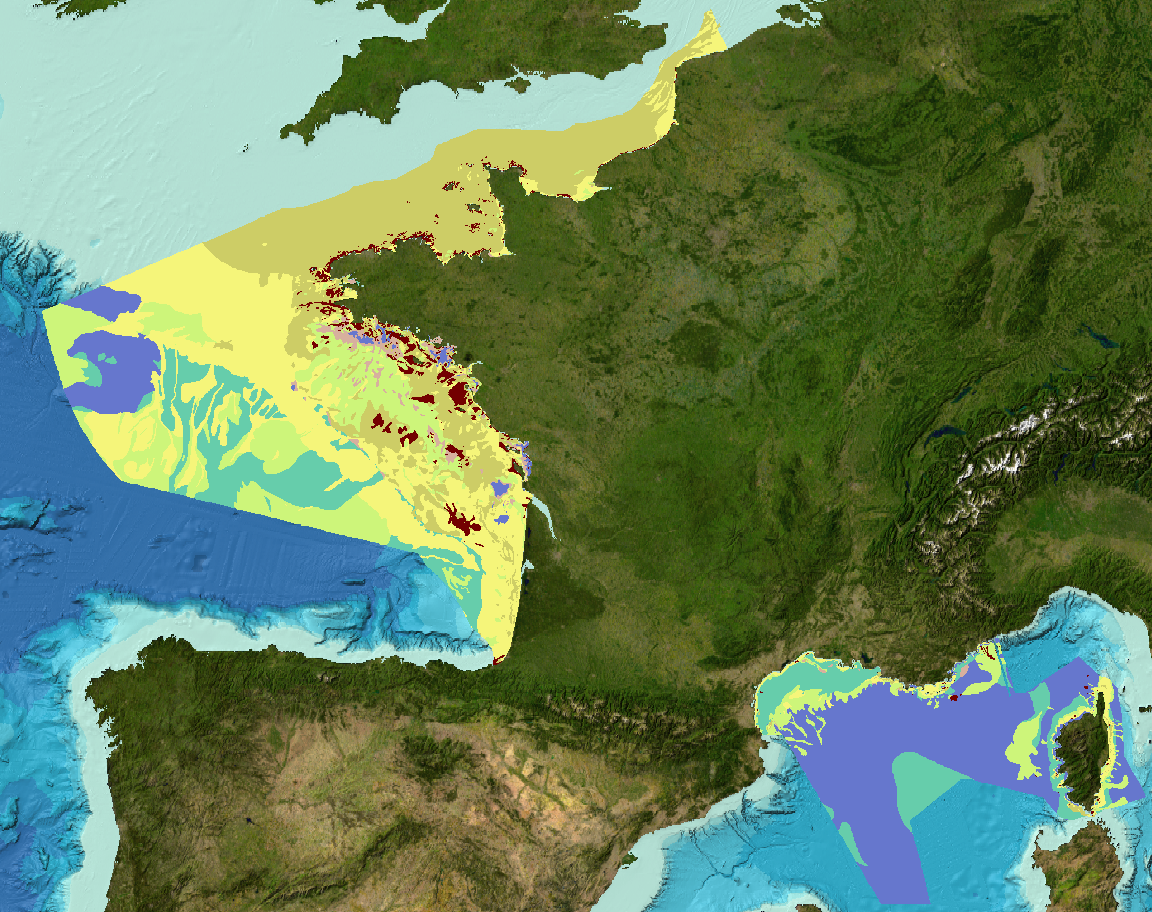
EMODNet Geology - Sediment substrate maps of the French metropolitan EEZ
Sediment substrate maps at different scales, of the French metropolitan EEZ produced in the work-package 3 the European project EMODNet Geology (phase IV).
Available scales :
- 1 : 1 000 000
- 1 : 250 000
- 1 : 100 000
- 1 : 50 000
- 1 : 20 000
- 1 : 15 000
- 1 : 10 000
- 1 : 5 000
Bibliographic references :
- Coltman, N., Gilliland, P. & van Heteren, S. 2007. What can I do with my map? In: MESH Guide to Habitat Mapping, MESH Project, 2007, JNCC, Peterborough. Available online at:
(http://www.searchmesh.net/default.aspx?page=1900)
- Foster-Smith, R., Connor, D. & Davies, J. 2007. What is habitat mapping? In: MESH Guide to Habitat Mapping, MESH Project, 2007, JNCC, Peterborough. Available
online at: (http://www.searchmesh.net/default.aspx?page=1900)
- Väänänen, T. (ed), Hyvönen, E., Jakonen, M., Kupila, J., Lerrsi, J., Leskinen, J., Liwata, P., Nevalainen, R., Putkinen, S., Virkki, H. 2007. Maaperän yleiskartan tulkinta- ja kartoitusprosessi. Maaperän yleiskartoitus –hankkeen sisäinen raportti. 17 p.
Simple
- Title
-
EMODNet Geology - Sediment substrate maps of the French metropolitan EEZ
- Date (Publication)
- 2017-04-14
- Date (Revision)
- 2024-05-17
- Citation identifier
- EMODNET_WP3_SeabedSubstrate_1M_2023
- Abstract
-
Sediment substrate maps at different scales, of the French metropolitan EEZ produced in the work-package 3 the European project EMODNet Geology (phase IV).
Available scales :
- 1 : 1 000 000
- 1 : 250 000
- 1 : 100 000
- 1 : 50 000
- 1 : 20 000
- 1 : 15 000
- 1 : 10 000
- 1 : 5 000
Bibliographic references :
- Coltman, N., Gilliland, P. & van Heteren, S. 2007. What can I do with my map? In: MESH Guide to Habitat Mapping, MESH Project, 2007, JNCC, Peterborough. Available online at:
(http://www.searchmesh.net/default.aspx?page=1900)
- Foster-Smith, R., Connor, D. & Davies, J. 2007. What is habitat mapping? In: MESH Guide to Habitat Mapping, MESH Project, 2007, JNCC, Peterborough. Available
online at: (http://www.searchmesh.net/default.aspx?page=1900)
- Väänänen, T. (ed), Hyvönen, E., Jakonen, M., Kupila, J., Lerrsi, J., Leskinen, J., Liwata, P., Nevalainen, R., Putkinen, S., Virkki, H. 2007. Maaperän yleiskartan tulkinta- ja kartoitusprosessi. Maaperän yleiskartoitus –hankkeen sisäinen raportti. 17 p.
- Credit
-
Ifremer, BRGM, SHOM, Université de Bordeaux 1
- Point of contact
-
Organisation name Individual name Electronic mail address Role Ifremer
Ifremer Geo-Ocean
Author Ifremer
Simplet Laure
Author European Commission
EMODNet Geology
Publisher
-
Thèmes Sextant
-
-
/Physical Environment/Geology
-
-
GEMET - INSPIRE themes, version 1.0
-
-
Geology
-
- Discipline
-
-
Sedimentology
-
-
Sous-regions marines
-
-
/Metropolitan France
-
-
Thématiques - SIMM
-
-
Research
-
/Environmental Status/Geology
-
- Use limitation
- CC-BY (Creative Commons - Attribution)
- Access constraints
- License
- Use constraints
- Other restrictions
- Other legal constraints
-
No public access restrictions
- Other legal constraints
-
Citation : European Commission – EMODNet Geology
- Spatial representation type
- Vector
- Denominator
- 1000000
- Denominator
- 250000
- Denominator
- 100000
- Denominator
- 50000
- Denominator
- 20000
- Denominator
- 15000
- Denominator
- 10000
- Denominator
- 5000
- Language
- Français
- Character set
- UTF8
- Topic category
-
- Oceans
))
- Reference system identifier
- EPSG / WGS 84 (EPSG:4326) / 8.6
- Geometric object type
- Surface
- Distribution format
-
Name Version ESRI Shapefile
1.0
- OnLine resource
-
Protocol Linkage Name WWW:LINK
http://www.emodnet.eu/geology EMODNet Geology
- OnLine resource
-
Protocol Linkage Name NETWORK:LINK
_REFERENTIELS\GEOLOGIE\FranceMetropole_EMODnetGeology\EMODnet_WP3_Sediments EMODnet_WP3_Sediments
- OnLine resource
-
Protocol Linkage Name OGC:WMS
https://sextant.ifremer.fr/services/wms/gm_geologie EMODNET_WP3_SeabedSubstrate_1M_2023
- OnLine resource
-
Protocol Linkage Name OGC:WMS
https://sextant.ifremer.fr/services/wms/gm_geologie EMODNET_WP3_SeabedSubstrate_250k_2023
- OnLine resource
-
Protocol Linkage Name OGC:WMS
https://sextant.ifremer.fr/services/wms/gm_geologie EMODNET_WP3_SeabedSubstrate_100k_2023
- OnLine resource
-
Protocol Linkage Name OGC:WMS
https://sextant.ifremer.fr/services/wms/gm_geologie EMODNET_WP3_SeabedSubstrate_50k_2023
- OnLine resource
-
Protocol Linkage Name OGC:WMS
https://sextant.ifremer.fr/services/wms/gm_geologie EMODNET_WP3_SeabedSubstrate_20k_2023
- OnLine resource
-
Protocol Linkage Name OGC:WMS
https://sextant.ifremer.fr/services/wms/gm_geologie EMODNET_WP3_SeabedSubstrate_15k_2023
OGC:WMS
https://sextant.ifremer.fr/services/wms/gm_geologie EMODNET_WP3_SeabedSubstrate_10k_2023
- OnLine resource
-
Protocol Linkage Name OGC:WMS
https://sextant.ifremer.fr/services/wms/gm_geologie EMODNET_WP3_SeabedSubstrate_5k_2023
- OnLine resource
-
Protocol Linkage Name COPYFILE
EMODnet_WP3_Sediments
- Hierarchy level
- Dataset
- Statement
-
These datasets are based on a compilation of data made available with free access for the project EMODnet.
The 1:1,000,000 and 1:250,000 scale datasets were produced according to a methodology for harmonizing and generalizing the original maps defined by the leaders (GTK, Finnish Geological Survey) of work-package 3 of the Geology batch of the European EMODnet project, based on the work of Väänänen et al. (2007).
Other, larger-scale datasets have not been harmonized using this methodology.
Sediment classification adopted is Folk, 1954 according 5, 7 or 16 classes.
The attribute table contains the following informations:
- Code : Code refers to maps/datasets, which are congruent by scale and mapping technology or have been published as an entity. Code includes a two-letter country code, which corresponds to ISO3166- code, plus 3 digits (numbers) that identify each map.
- Country : The country where the data originates.
- Name : Original title of the map
- DataHolder : Abbreviation of the organization/institute holding the map.
- Contact : email of the contact to get access or information about data
- Original_S(cale) : original map's scale
- Original_G(rain_Size) : grain-size classification system used in the original map
- MappingMet(hod) : How the original map was created. 1= Modelled, supervised 2.= Modelled, unsupervised 3 = Manually interpreted 4 = Other
- References. : bibliographical reference
- Comments : Comments or other information regarding the dataset
- Reclassifi : 1 = Sample-based reclassification, 2 = Expert-based prediction reclassification, 3 = Sample- and Expert-based reclassification, 4 = No reclassification needed, 0 = No info.
- Method : mapping method. 1 = Automatic interpolation of reclassified samples, 2 = Automatic interpolation of reclassified samples and acoustic-seismic-surveys, 3 = Reclassification of existing substrate categories on the grounds of analysed surface samples, 4 = Reclassification of existing substrate categories on the grounds of expert-based predicted, surface material, 5 = The original dataset is EMODnet compatible and no adjustments have been done, 0 = No info
- Sample_num : Approximate the minimum number of samples used per original substrate category.
- Original_1 (Original_substrate) : name of the original/National substrate category.
- Relation : code describes the relationship between original classification versus Folk classification : 1 = original substrate is same as Folk, 2 = original substrate is nearly the same as Folk, 3 = Folk is contained within original substrate, 4 = original_substrate is contained within Folk, 5 = original_substrate partially overlaps with Folk, 6 = no info
- Folk_16cl : facies code according to the Folk classification, 16 classes
- Folk_16cl_ : facies name according to the Folk classification, 16 classes
- Folk_7cl : facies code according to the Folk classification, 7 classes
- Folk_7cl_ : facies name according to the Folk classification, 7 classes
- Folk_5cl : facies code according to the Folk classification, 5 classes
- Folk_5cl_ : facies name according to the Folk classification, 5 classes
- Surface_Fe(ature) : geological seabed surface feature type e.g. Biogenic material, Hard clay, Till, Fe-Mn concretion field, Shell areas.
- Surface__1 (Surface_Fe_Gr) : surface feature group. 1. Hard clay 2. Fe-Mn concretion field 3. Biological features 4. Seagrass meadows and seaweed communities 5. Seagrass meadows 6. Anthropogenic 7. Bedrock 8. Biogenic reef 9. Shell deposits 10. Maerl deposit 11. Bioclastic 12. Mixture: Two or more listed features 13. Gas-bearing sediment 14. Pockmarks 15. Moving sediment 16. Till 17. Landslide deposit 18. Thin erosional sand/coarse sediment 19. Glaciofluvial gravel&sand 20. Boulders 21. Patchy seafloor 22. Peat 23. Organic 24. Recent/Modern soft sediment 25. Lag deposits 26. Lithoclastic sediment 27. Unclassified
- Conf_RS : RS = "Remote sensing". Score attributed for backscatter coverage. 0= No backscatter data, 1= backscatter coverage is moderate or poor (<90%) ; 2= backscatter coverage is good (up to 90%).
- Conf_S : Amount of samples. 1 = every class/polygon was sampled ; 0 = not every class/polygon was sampled
- Conf_D : Distinctness of class boundaries. 1 = predicted class boundaries are distinct ; 0 = predicted class boundaries are less distinct
- Conf_TOT : Score for confidence calculated as CONF_TOT= RS+S+D
Metadata
- File identifier
- c540dc17-299b-470a-b71c-fa9934c93847
- Metadata language
- Français
- Other language
-
Language Character encoding English UTF8
- Character set
- UTF8
- Hierarchy level
- Dataset
- Date stamp
- 2024-05-22T12:43:39.132Z
- Metadata standard name
-
ISO 19115:2003/19139 - SEXTANT
- Metadata standard version
-
1.0
- Metadata author
-
Organisation name Individual name Electronic mail address Role Ifremer
Simplet Laure
Local service desk
accessData
Overviews
)))