Bathymétrie - golfe du Lion, canyon Bourcart (campagne CALMAR99, 1999)
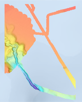
Bathymétrie du canyon Bourcart dans le golfe du Lion (campagne CALMAR99, 1999), à une résolution spatiale de 10 mètres. Les données ont été acquises par le sondeur EM1000 du N/O L'Europe lors de la campagne CALMAR99 en 1999.
Référence verticale : niveau observé des mers
Description de la campagne : BERNE Serge (1999) CALMAR99 cruise, RV L'Europe, https://doi.org/10.17600/99060050
Simple
- Title
-
Bathymétrie - golfe du Lion, canyon Bourcart (campagne CALMAR99, 1999)
- Alternate title
-
CALMAR99_Bourcart_10m_BATHY
- Date (Creation)
- 1999-01-01T00:00:00
- Date (Publication)
- 1999-01-01T00:00:00
- Citation identifier
- FR-330-715-368-00032-CALMAR99_Bourcart_10m_BATHY
- Presentation form
- Digital model
- Abstract
-
Bathymétrie du canyon Bourcart dans le golfe du Lion (campagne CALMAR99, 1999), à une résolution spatiale de 10 mètres. Les données ont été acquises par le sondeur EM1000 du N/O L'Europe lors de la campagne CALMAR99 en 1999.
Référence verticale : niveau observé des mers
Description de la campagne : BERNE Serge (1999) CALMAR99 cruise, RV L'Europe, https://doi.org/10.17600/99060050
- Credit
-
Ifremer / Université Perpignan Via Domitia
- Status
- On going
- Point of contact
-
Organisation name Individual name Electronic mail address Role Ifremer
Géosciences Marines
Author Université de Perpignan
BERNE Serge
Local service desk Ifremer
Ifremer
Publisher
- Maintenance and update frequency
- Not planned
-
Thèmes Sextant
-
-
/Milieu physique/Bathymétrie/MNT
-
-
GEMET - INSPIRE themes, version 1.0
-
-
Altitude
-
-
external.theme.gemet
-
-
Fond marin
-
Morphologie sous-marine
-
- Theme
-
-
Bathymétrie
-
- Place
-
-
Canyon Bourcart
-
Golfe du Lion
-
Méditerranée
-
- Discipline
-
-
Géophysique
-
- Use limitation
- CC BY. Licence Creative Commons Attribution 4.0 International https://creativecommons.org/licenses/by/4.0/
- Access constraints
- Other restrictions
- Other legal constraints
-
Pas de restriction d'accès public
- Use limitation
-
Ne pas utiliser pour la navigation
- Spatial representation type
- Grid
- Denominator
- 20000
- Distance
- 10 meter
- Language
- Français
- Character set
- UTF8
- Topic category
-
- Elevation
- Description
-
période d'acquisition des données
- Begin date
- 1999-06-12T00:00:00
- End date
- 1999-06-28T00:00:00
))
- Reference system identifier
- EPSG / WGS 84 / World Mercator (EPSG:3395) latitude 38°N / 7.4
- Number of dimensions
- 2
- Dimension name
- Row
- Dimension size
- 2007
- Resolution
- 10 m
- Dimension name
- Column
- Dimension size
- 1479
- Resolution
- 10 m
- Cell geometry
- Point
- Transformation parameter availability
Distributor
- Distributor contact
-
Organisation name Individual name Electronic mail address Role Ifremer - Centre de Brest
Dissemination Unit
- Distributor format
-
Name Version
- OnLine resource
-
Protocol Linkage Name WWW:LINK
http://dx.doi.org/10.17600/99060050
- OnLine resource
-
Protocol Linkage Name OGC:WMS
https://sextant.ifremer.fr/services/wms/gm_bathy CALMAR99_Bourcart_10m_BATHY
COPYFILE
CALMAR99_Bourcart_10m_BATHY
- OnLine resource
-
Protocol Linkage Name WWW:LINK-1.0-http--metadata-URL
https://doi.org/10.12770/c5d26bf0-cf96-11df-a9b6-005056987263 Digital Object Identifier (DOI)
- Hierarchy level
- Dataset
Vertical extent
- Minimum value
- -669.7
- Maximum value
- -102.34
Conformance result
- Title
-
INSPIRE
- Date (Publication)
- 2007-03-14
- Explanation
-
Non évalué
- Pass
- Statement
-
Données bathymétriques acquises par le sondeur EM1000 du N/O L'Europe. Traitement des données avec le logiciel Caraïbes (développé par l'Ifremer).
Metadata
- File identifier
- c5d26bf0-cf96-11df-a9b6-005056987263
- Metadata language
- Français
- Character set
- UTF8
- Hierarchy level
- Dataset
- Date stamp
- 2023-02-27T16:12:40.095Z
- Metadata standard name
-
ISO 19115:2003/19139 - SEXTANT
- Metadata standard version
-
1.0
- Metadata author
-
Organisation name Individual name Electronic mail address Role Ifremer
Géosciences Marines
Local service desk
accessData
Overviews
)))