Distribution of populations of the polychete Ditrupa arietina in the western Mediterranean
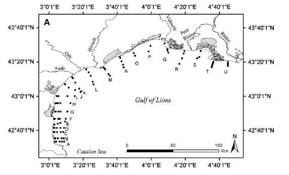
92 stations were sampled at depths of 10, 20, 30, 40 and 50 m from the Spanish border to the Rhône. All of these stations were again sampled in 2010.
Simple
- Title
-
Distribution of populations of the polychete Ditrupa arietina in the western Mediterranean
- Date (Creation)
- 1998-01-01T00:00:00
- Citation identifier
- FR-DCSMM-PDS-REDIT_1
- Presentation form
- Digital profile
- Abstract
-
92 stations were sampled at depths of 10, 20, 30, 40 and 50 m from the Spanish border to the Rhône. All of these stations were again sampled in 2010.
- Credit
-
Data producer : Station Marine Banyuls
- Status
- Completed
- Point of contact
-
Organisation name Individual name Electronic mail address Role LECOB FREE 3350
Labrune Céline
Local service desk
- Maintenance and update frequency
- Not planned
- Maintenance note
-
Network duration : temporary network
- Theme
-
-
Golfe of Lion
-
Benthic macrofauna
-
Revisit
-
Transect
-
-
GEMET - INSPIRE themes, version 1.0
-
-
Environmental monitoring facilities
-
-
Sous-regions marines
-
-
Western Mediterranean
-
-
DCSMM : Type d'espace concerné
-
-
Pas d'espace particulier concerné
-
-
DCSMM : Descripteurs
-
-
D1: Biodiversity
-
D2: Non-indigenous species
-
D4: Marine Food Webs
-
D6: Sea-floor Integrity
-
-
DCSMM : Méthodes de recueil des données
-
-
Observation par point
-
-
Thèmes Sextant
-
-
/Biological Environment/Habitats
-
- Access constraints
- Other restrictions
- Other legal constraints
-
Access conditions: Confidential
- Use limitation
-
Resomar data usage Charter :
http://resomar-benthos.epoc.u-bordeaux1.fr/docs/Charte_RESOMAR.pdf
- Spatial representation type
- Vector
- Denominator
- 500000
- Language
- Français
- Character set
- UTF8
- Topic category
-
- Biota
))
- Reference system identifier
- EPSG / WGS 84 (EPSG:4326) / 7.9
- Topology level
- Geometry only
- Geometric object type
- Complex
- Geometric object count
- 0
- Distribution format
-
Name Version
- Hierarchy level
- Dataset
Conformance result
- Title
-
Inspire specifications
- Date (Creation)
- 2012-01-16
- Explanation
-
Non assessed
- Pass
- Statement
-
1998 : Sampling begins
1998 : Sampling completed
Number of observation or measurement points : 92
Validation system: technical and scientific validation;
Taxonomic quality control, data validation and analysis.
Data stored in the Resomar benthos database.
- Description
-
Data type :
Fauna
Geology
Precision on the data type :
Fauna : benthic invertebrate macrofauna
Geology : sedimentology, physio-chemistry
Measured or observed parameters :
Specific composition, abundance, biomass, granulometry, organic matter content, physio-chemistry
Parameters resolution :
0.3 m²
Fréquence d'actualisation : Unique
Fréquence d'observation : Unique
- Description
-
Sampling method : Strata
- Description
-
Taxonomic reference : WoRMS
Metadata
- File identifier
- c6a734a1-c51a-467a-96c9-340f60af379a
- Metadata language
- Français
- Other language
-
Language Character encoding English
- Character set
- UTF8
- Parent identifier
-
RESeau des Stations et Observatoires Marins : suivis et base de données benthiques des côtes françaises métropolitaines depuis 1960
d2a8fe27-16b2-4e87-9668-f48c96766bf6
- Hierarchy level
- Dataset
- Date stamp
- 2020-06-04T00:47:41
- Metadata standard name
-
ISO 19115:2003/19139 - SEXTANT
- Metadata standard version
-
1.0
- Metadata author
-
Organisation name Individual name Electronic mail address Role Sextant
Local service desk
accessData
Overviews
)))