National Observation Network of Coastal Biocenosis / Benthic Network (REBENT)
National Coastal Biocenosis Observation Network
Simple
- Title
-
National Observation Network of Coastal Biocenosis / Benthic Network (REBENT)
- Date (Creation)
- 2003-01-01T00:00:00
- Citation identifier
- FR-DCSMM-PDS-REBENT
- Presentation form
- Digital profile
- Abstract
-
National Coastal Biocenosis Observation Network
- Purpose
-
The aims of the benthic network (REBENT) are to collect and organise data relating to the distribution of coastal habitats and the monitoring of their flora and fauna, in order to provide a pertinent and coherent inventory for scientists, biodiversity manager and the public, and to detect changes over space and time. First established in Brittany after the Erika oil spill, REBENT Bretagne made it possible to implement long-term institutional monitoring for the application of the Water Framework Directive (WFD) along the coast of mainland France. In Brittany, the mostly closely-related monitoring operations were funded in part within the context of who state-regional contracts, first in 2000-2006 and then 2007 – 2013.
- Credit
-
Data producers : Marine research stations in Wimereux (Université de Lille), Dinard (MNHN), Roscoff (Université UPMC Paris VI), Concarneau (MNHN), Arcachon (Université de Bordeaux), Stareso (Université de Liège) and Banyuls (Université UPMC Paris VI), Université de Bretagne occidentale/IUEM/LEMAR et LEBAHM, CNRS/Université de La Rochelle, Université de Nice, CEVA, GEMEL Normandie, Cellule du Suivi du Littoral Haut-Normand, Hémisphère Sub, Bio-Littoral, CREOCEAN, IFREMER (LER FBN, LER MPL, LER AC, LER PAC, LER LR)
- Status
- On going
- Point of contact
-
Organisation name Individual name Electronic mail address Role LER FBN / IFREMER
LE MAO Patrick
Local service desk
- Maintenance and update frequency
- Irregular
- Maintenance note
-
Durée du réseau : Dispositif pérenne
- Theme
-
-
Animal benthos
-
Plant benthos
-
Indicators
-
DCE
-
-
GEMET - INSPIRE themes, version 1.0
-
-
Environmental monitoring facilities
-
-
Sous-regions marines
-
-
/Métropole
-
Bay of Biscay
-
Channel-North Sea
-
Western Mediterranean
-
Celtic Seas
-
-
DCSMM : Type d'espace concerné
-
-
Pas d'espace particulier concerné
-
-
DCSMM : Descripteurs
-
-
D1: Coastal benthic habitats
-
-
DCSMM : Méthodes de recueil des données
-
-
Observation directe
-
Observation par transect
-
Observation par point
-
Télédétection
-
Interprétation de cartographies
-
-
Thèmes Sextant
-
-
/Human Activities/Scientific Activities
-
- Access constraints
- Other restrictions
- Other legal constraints
-
Free and open access
- Use limitation
-
The usual rules of surveillance data ton IFREMER, with sometimes moratoriums for the availability of the data
- Spatial representation type
- Vector
- Denominator
- 50000
- Language
- Français
- Character set
- UTF8
- Topic category
-
- Oceans
))
- Supplemental Information
-
Project leader :
Région Bretagne (Rebent-Bretagne) 2000
DREAL Bretagne (Rebent-Bretagne) 2000
DREAL La Réunion 2008
Agences de l’Eau (AEAP, AESN, AELB, AEAG, AERMC) pour la surveillance DCE 2006
Prime contractor :
Institut Français pour la Recherche et l'Exploitation de la MER 2000
Backer :
Agences de l’Eau 2006
DREAL Bretagne et La Réunion 2000
Conseil Régional de Bretagne 2000
DREAL La Réunion 2008
- Reference system identifier
- EPSG / WGS 84 (EPSG:4326) / 7.9
- Topology level
- Geometry only
- Geometric object type
- Complex
- Geometric object count
- 0
- Distribution format
-
Name Version
- OnLine resource
-
Protocol Linkage Name WWW:LINK
http://www.rebent.org Site internet Rebent
WWW:LINK
https://sextant.ifremer.fr/fr/geoportail/sextant#/search?fast=index&_groupPublished=REBENT Catalogue des cartes Rebent
- Hierarchy level
- Dataset
Conformance result
- Title
-
Inspire specifications
- Date (Creation)
- 2012-01-16
- Explanation
-
Non assessed
- Pass
- Statement
-
2000 : Implementation of a preliminary outline project (APS), followed by a detailed preliminary project (APD) in order to define a strategy and specify study methods and protocols
2003 : Operational phase of the Breton pilot scheme
2004 : Reflection on changes to make to the protocols for implementation of the WFD
2006 : Knowledge review and exploratory phase for the implementation of WFD monitoring network along the coast of mainland France
2007 : Start of benthic monitoring along the coast of mainland France
2008 : Reflection begins on the implementation of a benthic network in La Reunion
2012 : End of the first management plan 2007-2012
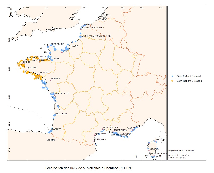
Number of observation or measurement points : 200
- Description
-
Data type :
Algae
Coastal Habitats
Fauna
Precision on the data type :
Intertidal and subtidal macroalgae Habitat characteristics
Benthic invertebrates (Intertidal and subtidal zones) Phanerogams (zostera, Posidonia oceanica)
Measured or observerd parameters :
Coverage
Surface area, granulometry, organic matter content,
Abundance, distribution, biomass, specific richness, diversity Density, coverage, foliar biometry, biomass, epiphytes, diseases
Parameters resolution :
By taxon
By site
Update frequency :
From twice yearly to once every three years
From twice yearly to once every three-six years
Once every 3 years
Observation frequency :
From twice yearly to once every three years
From twice yearly to once every three-six years
Once every 3 years
- Description
-
Taxonomic reference: European Register of Marine Species (ERMS)
- Description
-
Sampling plan :
Random, Spatial, Stratified
Validation method :
Quadrige² validation and qualification
- Description
-
Devices associated :
Monitoring of underground benthos of loose intertidal substrate
Monitoring of underground benthos of loose subtidal substrate
Monitoring of intertidal macroalgae populations
Monitoring of subtidal macroalgae populations
Monitoring of various sea grass beds : Zostera marina, Zostera noltii, Posidonia oceanica
Monitoring of opportunistic macroalgae blooms
Monitoring of maerl beds
Monitorying of macrophytes in Mediterranean lagoons.
Metadata
- File identifier
- ca64aed8-456f-4904-a2a3-59153dbdb659
- Metadata language
- Français
- Other language
-
Language Character encoding English
- Character set
- UTF8
- Hierarchy level
- Series
- Date stamp
- 2020-06-04T00:34:35
- Metadata standard name
-
ISO 19115:2003/19139 - SEXTANT
- Metadata standard version
-
1.0
- Metadata author
-
Organisation name Individual name Electronic mail address Role Sextant
Local service desk
accessData
Overviews
)))