Formations superficielles du domaine marin côtier de Saint-Malo à Granville (Ille-et-vilaine - Manche), scan géoréférencé
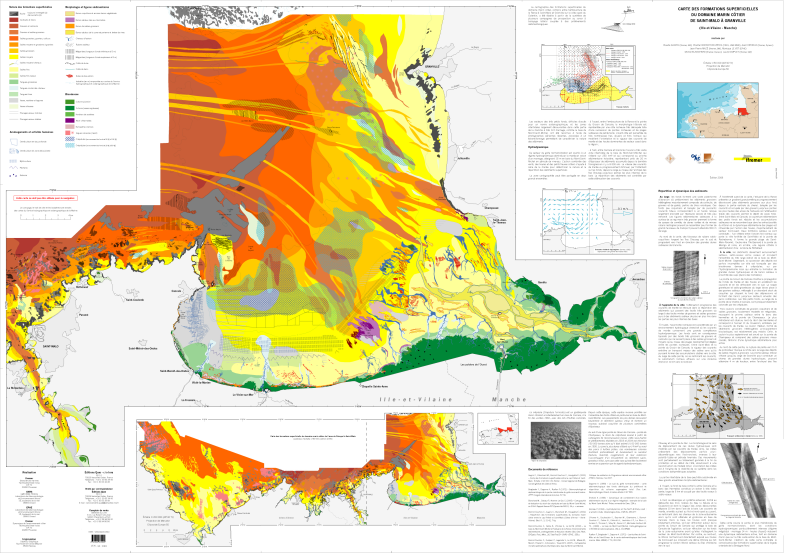
Scan géoréférencé de la "Carte des formations superficielles du domaine marin côtier du domaine côtier de Saint-Malo à Granville (Ille-et-vilaine - Manche)". Edition 2008. Echelle 1/50 000.
Campagnes océanographiques à l'origine de cette carte :
- CREPE 2 en 1995 (campagne non référencée)
- BLANCHARD Michel (1996) CREPE 3 cruise, RV Thalia, https://doi.org/10.17600/96070050
- BLANCHARD Michel (2003) SONARMONT 1 cruise, RV Thalia, https://doi.org/10.17600/3070120
- BLANCHARD Michel (2003) SONARMONT 2 cruise, RV Notre Dame, https://campagnes.flotteoceanographique.fr/campagnes/3790010/
- BLANCHARD Michel (2004) AREVAL04 cruise, RV Thalia, https://doi.org/10.17600/4070080
- campagnes CNRS/SHOM en 1995-1996
- OLIVIER Fredéric (2002) BENTHOMONT 2 cruise, RV Côtes De La Manche, https://doi.org/10.17600/2480020
- BENTHOMONT 3 en 2003, CNRS / MNHN (campagne non référencée)
Simple
- Title
-
Formations superficielles du domaine marin côtier de Saint-Malo à Granville (Ille-et-vilaine - Manche), scan géoréférencé
- Date (Publication)
- 2008-01-01T00:00:00
- Date (Creation)
- 2008-01-01T00:00:00
- Edition
-
Editions QUAE
- Edition date
- 2008-01-01T00:00:00
- Citation identifier
- FR-330-715-368-00032-IFR_SED_STMICHEL_2008_R
- Presentation form
- Digital map
- ISBN
-
2-978-2-84433-159-9
- Abstract
-
Scan géoréférencé de la "Carte des formations superficielles du domaine marin côtier du domaine côtier de Saint-Malo à Granville (Ille-et-vilaine - Manche)". Edition 2008. Echelle 1/50 000.
Campagnes océanographiques à l'origine de cette carte :
- CREPE 2 en 1995 (campagne non référencée)
- BLANCHARD Michel (1996) CREPE 3 cruise, RV Thalia, https://doi.org/10.17600/96070050
- BLANCHARD Michel (2003) SONARMONT 1 cruise, RV Thalia, https://doi.org/10.17600/3070120
- BLANCHARD Michel (2003) SONARMONT 2 cruise, RV Notre Dame, https://campagnes.flotteoceanographique.fr/campagnes/3790010/
- BLANCHARD Michel (2004) AREVAL04 cruise, RV Thalia, https://doi.org/10.17600/4070080
- campagnes CNRS/SHOM en 1995-1996
- OLIVIER Fredéric (2002) BENTHOMONT 2 cruise, RV Côtes De La Manche, https://doi.org/10.17600/2480020
- BENTHOMONT 3 en 2003, CNRS / MNHN (campagne non référencée)
- Credit
-
Ifremer / EPHE / CNRS
- Status
- Completed
- Point of contact
-
Organisation name Individual name Electronic mail address Role Ifremer
Geo-Ocean
Local service desk Ifremer
AUGRIS Claude
Author CNRS
BONNOT-COURTOIS Chantal
Author Ifremer
EHRHOLD Axel
Author Ifremer
MAZE Jean-Pierre
Author EPHE
LE VOT Monique
Author Ifremer
BLANCHARD Michel
Author Ifremer
SIMPLET Laure
Author
- Maintenance and update frequency
- Not planned
-
Thèmes Sextant
-
-
/Cartes scannées/Ifremer/Sédimentologie
-
-
GEMET - INSPIRE themes, version 1.0
-
-
Géologie
-
-
external.theme.gemet
-
-
fond marin
-
sédiment marin
-
- Theme
-
-
formations superficielles
-
natures des fonds
-
- Place
-
-
Saint-Malo
-
Granville
-
Mont Saint-Michel
-
Manche
-
Ille-et-Vilaine
-
Bretagne
-
- Discipline
-
-
géophysique
-
sédimentologie
-
- Use limitation
- L'atlas géologique de la baie de Lannion est disponible aux éditions Quae. Jeu de données réservé à l'Ifremer pour un usage interne.
- Access constraints
- Restricted
- Use constraints
- Restricted
- Other legal constraints
-
Proposition de citation : AUGRIS C., BONNOT-COURTOIS C., MAZE J. P., LE VOT M., SIMPLET L., EHRHOLD A., BLANCHARD M. (2006) - Carte des formations superficielles du domaine marin côtier de Saint-Malo à Granville (Manche - Ille-et-Vilaine). Echelle 1/50 000. Ed. Ifremer.
- Spatial representation type
- Grid
- Denominator
- 50000
- Language
- Français
- Character set
- UTF8
- Topic category
-
- Geoscientific information
- Description
-
période d'acquisition des données
- Begin date
- 1995-01-01T16:58:00
- End date
- 2003-01-01T16:58:00
))
- Reference system identifier
- EPSG / ED50 (EPSG:4230) Projection Mercator parallèle standard 48°40'N / 7.4
- Number of dimensions
- 2
- Dimension name
- Row
- Dimension size
- 5261
- Resolution
- 8.4661734 mètre,
- Dimension name
- Column
- Dimension size
- 7598
- Resolution
- 8.4658775 mètre,
- Cell geometry
- Area
- Transformation parameter availability
Distributor
- Distributor contact
-
Organisation name Individual name Electronic mail address Role Ifremer - Centre de Brest
Administrateur du serveur Sextant
Dissemination Unit
- Distributor format
-
Name Version GeoTIFF
1.0
- OnLine resource
-
Protocol Linkage Name WWW:LINK
http://dx.doi.org/10.17600/96070050
- OnLine resource
-
Protocol Linkage Name WWW:LINK
http://dx.doi.org/10.17600/3070120
- OnLine resource
-
Protocol Linkage Name WWW:LINK
http://campagnes.flotteoceanographique.fr/campagnes/3790010/
- OnLine resource
-
Protocol Linkage Name WWW:LINK
http://dx.doi.org/10.17600/4070080
- OnLine resource
-
Protocol Linkage Name WWW:LINK
http://dx.doi.org/10.17600/2480020
- Hierarchy level
- Dataset
Conformance result
- Title
-
INSPIRE
- Date (Publication)
- 2007-03-14
- Explanation
-
Non évalué
- Pass
- Statement
-
Carte originale papier scannée et géoréférencée.
Metadata
- File identifier
- de73b2a0-08fc-11e0-abec-005056987263
- Metadata language
- Français
- Character set
- UTF8
- Hierarchy level
- Dataset
- Date stamp
- 2023-05-23T13:46:56.489Z
- Metadata standard name
-
ISO 19115:2003/19139 - SEXTANT
- Metadata standard version
-
1.0
- Metadata author
-
Organisation name Individual name Electronic mail address Role Ifremer
Geo-Ocean
Local service desk
accessData
Overviews
)))