Terrestrial mapping | coastline | NOAA | NGA World Vector Shoreline
Simple
Identification info
- Alternate title
-
NGA World Vector Shoreline
- Date
- Citation identifier
- Terrestrial mapping | coastline | NOAA | NGA World Vector Shoreline
- Convention
-
gshhg-shp-2.3.5
- Purpose
-
The GSHHG is a high-resolution geography data set including coastlines, political borders, and rivers
- Status
- On going
- Point of contact
-
Organisation Individual Electronic mail address ORCID Role NOAA Shoreline
NOAA Shoreline
edmerp NOAA
edmo University of Hawaii / Joint Institute for marine and atmospheric research JIMAR
Originator
- Spatial representation type
- Vector
- Topic category
-
- Oceans
Extent
))
Vertical element
- Minimum value
- 0
- Maximum value
- 0
- Maintenance and update frequency
- As needed
- Used by challenges
-
-
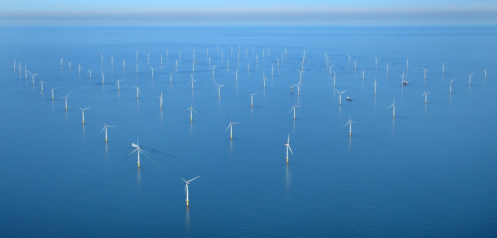
Atlantic - CH01 - Windfarm Siting
-
- Environmental matrix
-
-
Human activities
-
- Production mode
-
-
Delayed
-
- Visibility
-
-
Use of open search engines, searching by name either the data provider or the characteristics
-
- Policy visibility
-
-
There is no information at all on data policy adopted by data providers
-
- Readyness
-
-
Format not proprietary and content clearly specified (e.g. autodescriptive like ODV, NetCDF CF) or at least with appropriate document describing the content
-
- Parameter Discovery Vocabulary (P02)
-
-
Terrestrial mapping
-
- GEMET - INSPIRE themes, version 1.0
-
-
Land cover
-
- Processing level of characteristics
-
-
High level analyzed
-
- Data delivery mechanisms
-
-
Online downloading services
-
- Parameter Usage Vocabulary (other)
-
-
coastline
-
- Agreed Parameter Groups (P03)
-
-
Terrestrial
-
- Service extent
-
-
The datasets are referenced in a public national catalogue, in an international catalogue service
-
- Validation
-
-
Submitted
-
Resource constraints
- Access constraints
- Other restrictions
- Other constraints
-
Unrestricted
Resource constraints
- Use limitation
-
Open and Free. No charge
- Language
- Français
- Character encoding
- UTF8
- Environment description
-
This dataset will be used for determining the coastal limits across the Atlantic area.
Content Information
- Attribute description
- observation
- Content type
- Physical measurement
Distribution Information
- Distribution format
-
-
ESRI Shapefile
-
- OnLine resource
-
Shoreline Data
ATLANTIC_CH01_Product_1 / Map of offshore windfarm siting suitability in the geographic area where waters of France, Ireland and UK meet
))
- Begin date
- 2006-01-01
- End date
- 2015-12-31
Vertical element
- Minimum value
- 0
- Maximum value
- 0
ATLANTIC_CH01_Product_2 / Map of windfarm siting suitability in the area where waters of France and Spain meet in Bay of Biscay on 500 m contour
))
- Begin date
- 2006-01-01
- End date
- 2015-12-31
Vertical element
- Minimum value
- 0
- Maximum value
- 0
ATLANTIC_CH01_Product_3 / Map of windfarm siting suitability in the area of Southern border of Portugal and Spain at 20 m depth
))
- Begin date
- 2006-01-01
- End date
- 2015-12-31
Vertical element
- Minimum value
- 0
- Maximum value
- 0
ATLANTIC_CH01_Product_4 / Map of offshore windfarm siting suitability in the area off S. Miguel Island (Azores archipelago)
))
- Begin date
- 2006-01-01
- End date
- 2015-12-31
Vertical element
- Minimum value
- 0
- Maximum value
- 0
Resource lineage
- Hierarchy level
- Dataset
Spatial representation info
- Dimension name
- Time
- Cell geometry
- Transformation parameter availability
- true
- Check point availability
- true
Metadata
- Metadata identifier
- urn:uuid/e6739b31-2805-41b2-91da-d2f6115427f6
- Language
- English
- Character encoding
- UTF8
- Contact
-
Organisation Individual Electronic mail address ORCID Role Instituto Português do Mar e da Atmosfera (IPMA)
Type of resource
- Resource type
- Dataset
- Name
-
Atlantic - CH01 - Windfarm Siting
- Metadata linkage
-
https://sextant.ifremer.fr/geonetwork/srv/eng//metadata/e6739b31-2805-41b2-91da-d2f6115427f6
- Metadata linkage
-
https://sextant.ifremer.fr/geonetwork/srv/fre//metadata/e6739b31-2805-41b2-91da-d2f6115427f6
- Date info (Revision)
- 2018-03-15T10:43:52Z
- Date info (Creation)
- 2014-10-08T14:35:32
Metadata standard
- Title
-
ISO 19115-3 - Emodnet Checkpoint - Upstream Data
- Edition
-
1.0
gshhg-shp-2.3.5
accessData
Overviews
Spatial extent
)))