Fish and shellfish catch statistics | Regional Capture Fisheries Statistics FAO Major Fishing Areas 21&31 | Food and Agriculture Organization of the United Nations | Statistical Query Results
Simple
Identification info
- Alternate title
-
Statistical Query Results
- Date
- Citation identifier
- Fish and shellfish catch statistics | Regional Capture Fisheries Statistics FAO Major Fishing Areas 21&31 | Food and Agriculture Organization of the United Nations | Statistical Query Results
- Convention
-
Global Capture Production 1950-2015
- Purpose
-
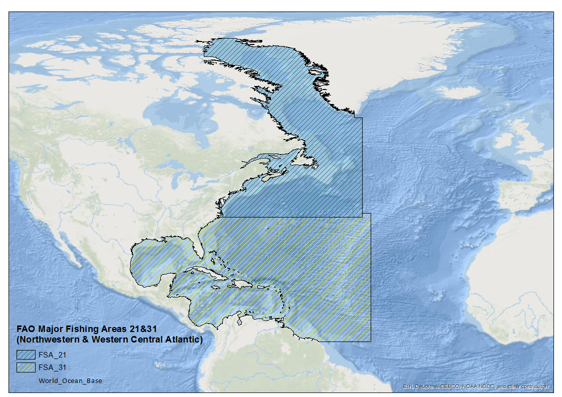
Fish Landings Statistics for FAO Fishing Areas 21&31
- Status
- On going
- Point of contact
-
Organisation Individual Electronic mail address ORCID Role Fisheries Global Information System
FIGIS
edmerp Food and Agriculture Organization of the United Nations
edmo Food and Agriculture Organization of the United Nations
Originator
- Spatial representation type
- Vector
- Topic category
-
- Oceans
Extent
))
Extent
- Time period
- 1950 2016
- Maintenance and update frequency
- Annually
- Used by challenges
-
-
Atlantic - CH07 - Fisheries Impact
-
- Environmental matrix
-
-
Human activities
-
- Production mode
-
-
Delayed
-
- Visibility
-
-
Search via reference catalogue (e.g. MyOcean, GEOSS Geoportal…)
-
- Policy visibility
-
-
There is detailed information provided to understand data policy
-
- Readyness
-
-
Format proprietary but content clearly specified
-
- Parameter Discovery Vocabulary (P02)
-
-
Fish and shellfish catch statistics
-
- GEMET - INSPIRE themes, version 1.0
-
-
Species distribution
-
- Processing level of characteristics
-
-
High level analyzed
-
- Data delivery mechanisms
-
-
Online downloading services
-
- Parameter Usage Vocabulary (other)
-
-
Regional Capture Fisheries Statistics FAO Major Fishing Areas 21&31
-
- Agreed Parameter Groups (P03)
-
-
Fisheries
-
- Service extent
-
-
The datasets are referenced in a public national catalogue, in an international catalogue service
-
- Validation
-
-
Draft
-
Resource constraints
- Access constraints
- Other restrictions
- Other constraints
-
Unrestricted
Resource constraints
- Use limitation
-
Free
- Language
- Français
- Character encoding
- UTF8
- Environment description
-
Used to identify nations fishing in the FAO Areas 21 & 31. Data contains fish catches by country, territory of capture by major FAO fishing areas. Data can be queried using the online query option then exported as a excel file.
Content Information
- Attribute description
- observation
- Content type
- Physical measurement
Distribution Information
- Distribution format
-
-
ZIP
-
XLS
-
- OnLine resource
-
Global Capture Production
- OnLine resource
-
FAO Major Fishing Areas 21&31
ATLANTIC_CH07_Product_1 / Area where bottom habitat has been disturbed by bottom trawling (number of disturbances per month)
-
Component is not covered because existing data not available
-
This component was created to outline non EU areas present in the Atlantic, but due to fishing effort data availability and so forth; a product covering these areas cannot be created. Data extracted using Global Capture Production (online query) statistics from the Food and Agricultural Organization of the United Nations (FAO) Fisheries and Aquaculture Departments, in the region show various EU flag states, Norwegian, the Russian Federation, Faroe Islands, Greenland, Iceland, Japan, and the Ukraine actively fishing is this region. The usability of this capture quantity data is unrestricted, however availability of VMS or Logbook data to form a high resolution fishing effort analysis of the region is not available.
))
- Begin date
- 2006
- End date
- 2016After
Vertical element
- Minimum value
- 0
- Maximum value
- 1000
ATLANTIC_CH07_Product_2 / Damage to seafloor to both living and non-living components
-
Component is not covered because existing data not available
-
This component was created to outline non EU areas present in the Atlantic, but due to fishing effort data availability and so forth; a product covering these areas cannot be created. Data extracted using Global Capture Production (online query) statistics from the Food and Agricultural Organization of the United Nations (FAO) Fisheries and Aquaculture Departments, in the region show various EU flag states, Norwegian, the Russian Federation, Faroe Islands, Greenland, Iceland, Japan, and the Ukraine actively fishing is this region. The usability of this capture quantity data is unrestricted, however availability of VMS or Logbook data to form a high resolution fishing intensity analysis of the region is not available.
- Begin date
- 2006
- End date
- 2016
Vertical element
- Minimum value
- 0
- Maximum value
- 1000
Resource lineage
- Hierarchy level
- Dataset
Spatial representation info
- Dimension name
- Time
- Resolution
- 1 year
- Cell geometry
- Transformation parameter availability
- true
- Check point availability
- true
Metadata
- Metadata identifier
- urn:uuid/e7025197-0abc-48fb-a780-30362da7ecc7
- Language
- English
- Character encoding
- UTF8
- Contact
-
Organisation Individual Electronic mail address ORCID Role Marine Institute
Type of resource
- Resource type
- Dataset
- Name
-
Atlantic - CH07 - Fisheries Impact
- Metadata linkage
-
https://sextant.ifremer.fr/geonetwork/srv/eng//metadata/e7025197-0abc-48fb-a780-30362da7ecc7
- Date info (Revision)
- 2018-04-10T14:31:26Z
- Date info (Creation)
- 2018-02-26T16:42:56
- Date info (Creation)
- 2018-02-26T16:41:58
- Date info (Creation)
- 2014-10-08T14:35:32
Metadata standard
- Title
-
ISO 19115-3 - Emodnet Checkpoint - Upstream Data
- Edition
-
1.0
Global Capture Production 1950-2015
accessData
Overviews
Spatial extent
)))